
The Humber River is a river in Southern Ontario, Canada. It is in the Great Lakes Basin, is a tributary of Lake Ontario and is one of two major rivers on either side of the city of Toronto, the other being the Don River to the east. It was designated a Canadian Heritage River on September 24, 1999.

The Peace–Athabasca Delta, located in northeast Alberta, is the largest freshwater inland river delta in North America. It is located partially within the southeast corner of Wood Buffalo National Park, Canada's largest national park, and also spreads into the Regional Municipality of Wood Buffalo, west and south of the historical community of Fort Chipewyan. The delta encompasses approximately 321,200 ha, formed where the Peace and Athabasca rivers converge on the Slave River and Lake Athabasca. The delta region is designated a wetland of international importance and a UNESCO World Heritage Site. The region is large enough that it is considered one of twenty distinct natural subregions of Alberta by the provincial government's Natural Regions Committee.

Clear Creek State Forest is a Pennsylvania State Forest in Pennsylvania Bureau of Forestry District #8. The main offices are located in Clarion in Clarion County, Pennsylvania in the United States. Until August 2007, it was named Kittanning State Forest.

North Thompson Oxbows Jensen Island Provincial Park is a provincial park in Thompson-Nicola Regional District in the Interior region of British Columbia, Canada, about 20 kilometres (12 mi) north of Kamloops at the community of Heffley Creek. The park was established on April 30, 1996, and has an area of 30 hectares. It protects the riparian habitat of a single, seasonal oxbow on the right bank of the North Thompson River. There are no camping or day-use facilities.

The Mount Meager massif is a group of volcanic peaks in the Pacific Ranges of the Coast Mountains in southwestern British Columbia, Canada. Part of the Cascade Volcanic Arc of western North America, it is located 150 km (93 mi) north of Vancouver at the northern end of the Pemberton Valley and reaches a maximum elevation of 2,680 m (8,790 ft). The massif is capped by several eroded volcanic edifices, including lava domes, volcanic plugs and overlapping piles of lava flows; these form at least six major summits including Mount Meager which is the second highest of the massif.
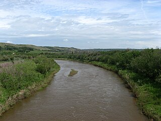
Battle River is a river in central Alberta and western Saskatchewan. It is a major tributary of the North Saskatchewan River.

The Smoky River is a river in western Alberta, Canada. It is a major tributary of the Peace River. The descriptive name refers to the presence of "smouldering beds of coal in the riverbank" noted by the Cree Indians.

The Berens River is a river in the provinces of Manitoba and Ontario, Canada. It flows west from an unnamed lake in Kenora District, Ontario and discharges its waters into Lake Winnipeg near the village and First Nation of Berens River, Manitoba. The river has a number of lakes along its course, and many rapids.

Lac-Sainte-Thérèse is a Dispersed Rural Community and unincorporated area in geographic Casgrain Township, Cochrane District in Northeastern Ontario, Canada. The community is counted as part of Unorganized Cochrane North Part in Canadian census data.
Kitselas First Nation is the band government of the Kitselas subgroup of the Tsimshian. The band government is based at Gitaus in the Skeena Valley in the Skeena River valley to the northeast of the city of Terrace, British Columbia, Canada. Though there is no Tsimshian tribal council, they are a participant in the Tsimshian First Nations treaty council.

The Volcano, also known as Lava Fork volcano, is a small cinder cone in the Boundary Ranges of the Coast Mountains in northwestern British Columbia, Canada. It is located approximately 60 km (40 mi) northwest of the small community of Stewart near the head of Lava Fork. With a summit elevation of 1,656 m (5,433 ft) and a topographic prominence of 311 m (1,020 ft), it rises above the surrounding rugged landscape on a remote mountain ridge that represents the northern flank of a glaciated U-shaped valley.

The US state of Colorado has vast wind energy resources and the installed electricity capacity and generation from wind power in Colorado has been growing significantly in recent years. The growth has been sustained due to a combination of falling costs, continuing federal incentives, and the state's aggressive renewable portfolio standard that requires 30% of the state's electricity to come from renewable sources by 2020.

Grand Lake is a lake in the Ottawa River drainage basin in the geographic townships of Barron and Stratton in the Unorganized South Part of Nipissing District in Northeastern Ontario, Canada.
The Echoing River is a river in the Hudson Bay drainage basin in Manitoba and Ontario, Canada. Its flows from its source at Echoing Lake in Unorganized part of Kenora District, Northwestern Ontario to its mouth as a right tributary of the Gods River in Northern Manitoba. The Gods River flows via the Hayes River to Hudson Bay.
Lee Township is a geographic township in the Unorganized West Part of Timiskaming District in northeastern Ontario, Canada. The township is uninhabited, and has no communities.

McKenzie Lake is a lake in geographic Speight Township in the Unorganized West Part of Timiskaming District in northeastern Ontario, Canada. It is part of the Saint Lawrence River drainage basin, and is about 20 kilometres (12 mi) southwest of the community of Kenabeek.

Silver Lake is a lake in Tay Valley, Lanark County, and Central Frontenac, Frontenac County, in Eastern Ontario, Canada. It is the source of Silver Lake Creek and is in the Ottawa River drainage basin.

Ruhl Creek is a stream in the township municipality of Brockton, Bruce County in Southwestern Ontario, Canada. It is in the Lake Huron drainage basin and is a right tributary of the Saugeen River.
Vesta Creek is a stream in the municipalities of Arran–Elderslie and Brockton, Bruce County in Southwestern Ontario, Canada. It is in the Lake Huron drainage basin and is a right tributary of the Saugeen River.
