
The Permian Basin is a large sedimentary basin in the southwestern part of the United States. It is the highest producing oil field in the United States, producing an average of 4.2 million barrels of crude oil per day in 2019. This sedimentary basin is located in western Texas and southeastern New Mexico.

The Colorado Plateau is a physiographic and desert region of the Intermontane Plateaus, roughly centered on the Four Corners region of the southwestern United States. This plateau covers an area of 336,700 km2 (130,000 mi2) within western Colorado, northwestern New Mexico, southern and eastern Utah, northern Arizona, and a tiny fraction in the extreme southeast of Nevada. About 90% of the area is drained by the Colorado River and its main tributaries: the Green, San Juan, and Little Colorado. Most of the remainder of the plateau is drained by the Rio Grande and its tributaries.

Victorio was a warrior and chief of the Warm Springs band of the Tchihendeh division of the central Apaches in what is now the American states of Texas, New Mexico, Arizona, and the Mexican states of Sonora and Chihuahua.

The Guadalupe Mountains are a mountain range located in West Texas and southeastern New Mexico. The range includes the highest summit in Texas, Guadalupe Peak, 8,751 ft (2,667 m), and the "signature peak" of West Texas, El Capitan, both of which are located within Guadalupe Mountains National Park. The Guadalupe Mountains are bordered by the Pecos River valley and Llano Estacado to the east and north, Delaware Mountains to the south, and Sacramento Mountains to the west. One of the clearest exposures of a prehistoric reef is preserved in the mountain range's bedrock geology. Bedrock contains fossils of reef-dwelling organisms from the Permian period, and the geology is widely studied, mostly by stratigraphers, paleontologists, and Paleoecologists.

The Delaware Basin is a geologic depositional and structural basin in West Texas and southern New Mexico, famous for holding large oil fields and for a fossilized reef exposed at the surface. Guadalupe Mountains National Park and Carlsbad Caverns National Park protect part of the basin. It is part of the larger Permian Basin, itself contained within the Mid-Continent oil province.

The Sacramento Mountains are a mountain range in the south-central part of the U.S. state of New Mexico, lying just east of Alamogordo in Otero County. From north to south, the Sacramento Mountains extend for 85 miles (137 km), and from east to west they encompass 42 miles (68 km).

The Sierra Blanca is an ultra-prominent range of volcanic mountains in Lincoln and Otero counties in the south-central part of the U.S. state of New Mexico. The range is about 40 miles (64 km) from north to south and 20 miles (32 km) wide.

The Tularosa Basin is a graben basin in the Basin and Range Province and within the Chihuahuan Desert, east of the Rio Grande in southern New Mexico and West Texas, in the Southwestern United States.
Oliver Lee Memorial State Park is a state park of New Mexico, United States, whose two tracts preserve a canyon in the Sacramento Mountains and Oliver Lee's historic 19th-century ranch house. The 640-acre (260 ha) park is located in Otero County at an elevation of 4,363 feet (1,330 m). It is situated at the base of Dog Canyon and provides opportunities for camping, hiking, picnicking, wildlife viewing, a nature trail, and guided tours of the ranch house.

The San Juan Basin is a geologic structural basin located near the Four Corners region of the Southwestern United States. The basin covers 7,500 square miles and resides in northwestern New Mexico, southwestern Colorado, and parts of Utah and Arizona. Specifically, the basin occupies space in the San Juan, Rio Arriba, Sandoval, and McKinley counties in New Mexico, and La Plata and Archuleta counties in Colorado. The basin extends roughly 100 miles (160 km) N-S and 90 miles (140 km) E-W.
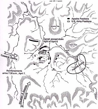
The Battle of Hembrillo Basin was fought April 5–8, 1880 between the United States Army against a combined band of Chiricahua and Mescalero Apaches led by Chief Victorio. Hembrillo Basin was the largest battle of Victorio's War, although casualties were light on both sides. Victorio held off an attack by superior numbers of army soldiers and Indian scouts, evacuated his women and children from the battlefield, and withdrew successfully. Hembrillo Basin is located on the White Sands Missile Range and access by the public is strictly regulated.
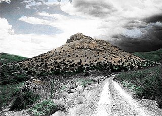
The Victorio Peak treasure describes a cache of gold reportedly found inside Victorio Peak in 1937 in southern New Mexico.
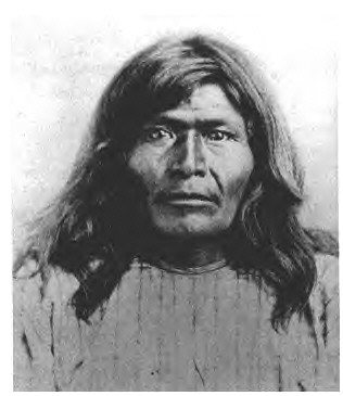
Victorio's War, or the Victorio Campaign, was an armed conflict between the Apache followers of Chief Victorio, the United States, and Mexico beginning in September 1879. Faced with arrest and forcible relocation from his homeland in New Mexico to San Carlos Indian Reservation in southeastern Arizona, Victorio led a guerrilla war across southern New Mexico, west Texas and northern Mexico. Victorio fought many battles and skirmishes with the United States Army and raided several settlements until the Mexican Army killed him and most of his warriors in October 1880 in the Battle of Tres Castillos. After Victorio's death, his lieutenant Nana led a raid in 1881.

The Caballo Mountains, are a mountain range located in Sierra and Doña Ana Counties, New Mexico, United States. The range is located east of the Rio Grande and Caballo Lake, and west of the Jornada del Muerto; the south of the range extends into northwest Doña Ana County. The nearest towns are Truth or Consequences and Hatch.
The Cherry Canyon Formation is a geologic formation found in the Delaware Basin of southeastern New Mexico and western Texas. It contains fossils characteristic of the Guadalupian Age of the Permian Period.
The Bone Spring Formation is a geologic formation found in the Delaware Basin in Texas and New Mexico. It preserves fossils dating back to the Leonardian Age of the Permian Period.
The Cutoff Formation is a geologic formation in Texas and New Mexico, US. It preserves fossils dating back to the Permian period.
The Victorio Peak Formation is a geologic formation found in the Delaware Basin in Texas and New Mexico. It preserves fossils dating back to the Leonardian Age of the Permian Period.
Victorio, was a warrior and chief of the Apaches in and around Texas and New Mexico.
