Vila Pouca de Aguiar (Portuguese pronunciation: [ˈvilɐˈpo(w)kɐðɨɐɣiˈaɾ] ⓘ ) is a municipality in the district of Vila Real in northern Portugal. Its population in 2011 was 13,187, [1] in an area of 437.07 km2. [2] It has about 3,456 residents.
There are various theories on the municipality's origins. Some historians believe it was the successor to the ancient city of Cauca, governed by Emperor Theodosius I; [3] however, it is uncertain why or when its name would have been changed from Cauca to Pouca. [3] Another theory is that "Vila Pouca" referred to a small agrarian community, and that "Aguiar" referred to an ancient administrative region, to disambiguate it from other communities named Vila Pouca. [3] Although the name means "Vila Pouca of Aguiar", "aguiar" is derived from aquila ("where the eagles are"). [3]
In the 13th century, the municipality was part of the land of Aguiar. [3] In the 12 and 13th centuries, Aguiar consisted of seven ecclesiastical parishes, including São Salvador de Jugal, which corresponded to the actual parish of Vila Pouca de Aguiar. [3] The Inquirições (inquiries/inventory) of King Afonso II established that the parochia of São Salvador de Jugal was composed of these localities and towns: Condado (three couples); Calvos (one couple); Guilhado (four couples) and Nuzedo (20 couples), in addition to the towns of Fraengo and Outeiro. [3] The document also identifies Jugal as an administrative unit, with elaborated administrative domain over the territory of Aguiar, and where the parochial church was located, but no reference to Jugal as a town. [3]
There is no historical explanation for the name-change from São Salvador de Jugal to Vila Pouca, nor when it occurred, although it was sometime in the 14th century. [3]
In the early 20th century, the area's leading figure was Martiniano José Ferreira Botelho, a doctor, druggist, and politician known for his humanitarian character and his advocacy of the local medicinal waters for treatments. [4] He and his family donated land to the community for the current market square, municipal slaughterhouse and well.
Integrated into the Alto Tâmega subregion, the municipality of Vila Pouca de Aguiar is situated in the north of the district of Vila Real, between the mountains of Serra do Alvão and Serra da Padrela, extending over a territory of approximately 437 km2. It is located within a strategic connection, not just between other Portuguese municipalities in the interior but also, as a transit point to the coastal areas (across the A7 and A24 motorways). Within a long fertile valley, and surrounded by high pasture-lands, it is defensively safe within the Transmontana escarpments. The region is covered in national monuments and historical structures: the Castle of Aguiar da Pena, the millenarian Roman mining complex of Tresminas, the thermals of Pedras Salgadas, several leisure centres (such as the Falperra Dam/Reservoir), the Dolmens of Alvão, churches, graves/funeral sites, medieval bridges, sun-dials and castro dot the landscape of this unassuming region. It is located in a narrow valley 25 kilometers north of the district capital, Vila Real, and is connected to the same by national N2 highway.
In 2006 the A7 toll road to Guimarães was completed and the last stretch of the A24, connecting Vila Pouca with Vila Real was opened in June 2007. This non-toll four-lane highway links Coimbra with the Spanish border in Vila Verde. One of the longest and highest highway bridges in Europe was built just south of Vila Pouca, carrying traffic across the fertile valley. [3]
Administratively, the municipality is divided into 14 civil parishes ( freguesias ): [5]
Vila Pouca de Aguiar has for many years experienced the desertification of the Portuguese interior. Population densities have historically identified a strong concentration of people in the municipal seat, or its peripheral parishes. [3] From 1981 to 1991, the parishes of Bragado, Pensalves, Afonsim, Vreia de Jales, Vreia de Bornes, Valoura and Soutelo de Aguiar have registered flawing population growth rates. [3] The parish of Sabroso de Aguiar did not exist in 1981, but by 1991 it registered the highest population concentration in the region. Comparatively, between 1991 and 2001, there were no changes in population densities in many of the parishes. [3] The municipal seat and Sabroso de Aguiar continue to show a growth in population density. [3]
Climate data for Santa Marta da Montanha, altitude: 866 m (2,841 ft) | |||||||||||||
---|---|---|---|---|---|---|---|---|---|---|---|---|---|
Month | Jan | Feb | Mar | Apr | May | Jun | Jul | Aug | Sep | Oct | Nov | Dec | Year |
Average precipitation mm (inches) | 250 (9.8) | 222 (8.7) | 188 (7.4) | 141 (5.6) | 140 (5.5) | 80 (3.1) | 30 (1.2) | 34 (1.3) | 88 (3.5) | 172 (6.8) | 217 (8.5) | 237 (9.3) | 1,799 (70.7) |
Source: Portuguese Environment Agency [6] |
Vila Pouca de Aguiar is twinned with:
Part of region characterized by fertile soils, and the typical climate of the Terra Fria Transmontana, the municipality of Vila Pouca de Aguiar is essentially subsistence agricultural, cultivating cereal crops, potato, vegetables and supporting some vineyards. [3] The small valleys support cattle which graze in the open pasturelands. The lands of the Alvão valley benefited from the construction of the Alvão Dam/Reservoir, which allowed irrigation of these lands since the mid-20th century. [3]
In addition, the economy supports small service industries, government-based dominated tertiary employment, the granite extraction industry (concentrated in the mines of Jales) and the mineral waters in Pedras Salgadas, a small spa town located about ten kilometers north on the main highway to Chaves. [3]
Pedras Salgadas is a small spa town in the district of Vila Real, in Northern Portugal, located approximately 37 km north of the district capital of Vila Real. It is famous for its mineral waters. There are several small hotels in the area, which cater to tourists who want to relax in the green countryside and benefit from the spa facilities located there. In 2010, the Portuguese beer and water company Unicer opened a brand new spa complex in the town. Pedras Salgadas is situated in the municipality of Vila Pouca de Aguiar. Both are located on N2, the national road linking Chaves with Vila real. The new four-lane A24 highway passes a few kilometers west of the town and is connected by a feeder road. The railway was closed in the 1980s and the abandoned railway bed has now been paved for use as a cycling and walking path. This path extends to Vila Pouca de Aguiar, at a distance of about 10 kilometers.
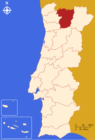
The District of Vila Real is a district of northern Portugal. With an area of 4,239 km2 (1,637 sq mi), the district is located east of the port city of Porto and north of the Douro River. Vila Real has always belonged to the historical province of Trás-os-Montes. Approximate population in the 2001 census was 230,000. The population has shown negative rates in recent years due to emigration and aging. Many of the villages have lost population and have become deserted while the district capital has gained in population. It is bordered by Spain (Galicia) in the north and east, Braga District and Porto District in the west, Viseu District in the south and Bragança District in the east.
Sabrosa is a municipality in the district of Vila Real in northern Portugal. The population in 2011 was 6,361, in an area of 156.92 km2.
Alto Trás-os-Montes, or Nordeste Transmontano, is a former NUTS-level 3 subregion of the Norte Region of Portugal. It was abolished at the January 2015 NUTS 3 revision. Its 15 municipalities occupied an area of 8,168 km2 (3,154 sq mi) in the north-east of continental Portugal with an estimated 2008 population of 214,460 inhabitants; thus it constituted approximately 40% of the area, but only 6.1% of the population, of the Norte Region.
Arcos de Valdevez is a municipality along the northern frontier of Portugal and Galicia (Spain). The population in 2011 was 22,847, in an area of 447.60 km2. It is the largest municipality in area of the district of Viana do Castelo.
Mogadouro is a municipality in Portugal. The population in 2011 was 9,542, in an area of 760.65 km2.
Aguiar da Beira is a municipality in Guarda District in Portugal. The population in 2011 was 5,473, in an area of 206.77 km2 (79.83 sq mi).
Valpaços is a municipality in northern Portugal. The population in 2011 was 16,882, in an area of 548.74 km2.
The House of the County or Casa do Condado is since 2007 the museum of Vila Pouca de Aguiar in Portugal. It includes a collection of cultural goods constituted by archaeological and ethnographic materials of great value from the region.
Vila Real is the capital and largest city of the Vila Real District, in the North region, Portugal. It is also the seat of the Douro intermunicipal community and of the Trás-os-Montes e Alto Douro historical province. The Vila Real municipality covers an area of 378.80 square kilometres (146.26 sq mi) and is home to an estimated population of 49,574 (2021), of which about 30,000 live in the urban area (2021).
The Castle of Folgosinho, is a medieval castle in the civil parish of Folgosinho, municipality of the Gouveia in the district of Guarda in the Centre region of Portugal.
The Castle of Freixo de Numão is a Portuguese medieval castle in civil parish of Freixo de Numão, in the municipality of Vila Nova de Foz Côa, in the district of Guarda.
The Castle of Pena de Aguiar is a medieval castle, alternately the Castle of Aguiar da Pena, situated in the civil parish of Telões, in the municipality of Vila Pouca de Aguiar, in the Portuguese district of Vila Real.
The Castle of Bemposta is a medieval castle in the civil parish of Bemposta, municipality of Mogadouro, in the Portuguese district of Bragança.
The 2019–20 Taça de Portugal was the 80th edition of the Taça de Portugal, the premier knockout competition in Portuguese football. A total of 144 clubs entered this edition, including teams from the top three tiers of the Portuguese football league system and representatives of the fourth-tier District leagues and cups. This was the first season to allow a fourth substitution during extra time.
{{citation}}
: CS1 maint: location missing publisher (link)