Viljoensdrif | |
|---|---|
 Viljoensdrif  Viljoensdrif | |
| Coordinates: 26°44′00″S27°55′00″E / 26.73333°S 27.916667°E Coordinates: 26°44′00″S27°55′00″E / 26.73333°S 27.916667°E | |
| Country | South Africa |
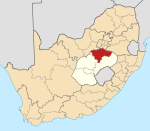
| Province | Free State |
| District | Fezile Dabi |
| Municipality | Metsimaholo |
| Area | |
| • Total | 63.30 km2 (24.44 sq mi) |
| Population (2011) [1] | |
| • Total | 751 |
| • Density | 12/km2 (31/sq mi) |
| Racial makeup (2011) | |
| • Black African | 73.8% |
| • Coloured | 1.5% |
| • Indian/Asian | 0.7% |
| • White | 6.9% |
| • Other | 17.2% |
| First languages (2011) | |
| • Sotho | 28.5% |
| • Zulu | 20.1% |
| • Xhosa | 17.4% |
| • Afrikaans | 10.2% |
| • Other | 23.8% |
| Time zone | UTC+2 (SAST) |
| Area code | 016 |
Viljoensdrif is a coal-mining village 8 km south of Vereeniging and part of the Fezile Dabi District Municipality in the Free State province of South Africa.

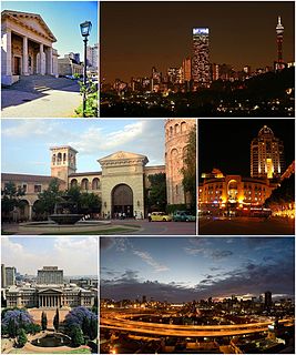
Vereeniging is a city in Gauteng province, South Africa, situated where the Klip River empties into the northern loop of the Vaal River. It is also one of the constituent parts of the Vaal Triangle region and was formerly situated in the Transvaal province. The name Vereeniging is derived from the Dutch word meaning "association" or "union".
Fezile Dabi District Municipality, formerly known as Northern Free State District Municipality, is one of the 5 districts of Free State province of South Africa. The seat of Northern Free State is Sasolburg. The majority of its 460 289 people speak Sesotho. The district code is DC20.

South Africa, officially the Republic of South Africa (RSA), is the southernmost country in Africa. It is bounded to the south by 2,798 kilometres (1,739 mi) of coastline of Southern Africa stretching along the South Atlantic and Indian Oceans; to the north by the neighbouring countries of Namibia, Botswana, and Zimbabwe; and to the east and northeast by Mozambique and Eswatini (Swaziland); and it surrounds the enclaved country of Lesotho. South Africa is the largest country in Southern Africa and the 25th-largest country in the world by land area and, with over 57 million people, is the world's 24th-most populous nation. It is the southernmost country on the mainland of the Old World or the Eastern Hemisphere. About 80 percent of South Africans are of Sub-Saharan African ancestry, divided among a variety of ethnic groups speaking different African languages, nine of which have official status. The remaining population consists of Africa's largest communities of European (White), Asian (Indian), and multiracial (Coloured) ancestry.
It takes its name from ford (Afrikaans drif) which was closed to ox-wagons by President Paul Kruger in 1895 to prevent goods reaching the Witwatersrand, thus forcing people to use the Netherlands-South African Railway Company P(NZASM)'sretoria-Delagoa Bay railroad. Named after the owner of the place, J H Viljoen, who established a ferry in 1857. [2]

A ford is a shallow place with good footing where a river or stream may be crossed by wading, or inside a vehicle getting its wheels wet. A ford may occur naturally or be constructed. Fords may be impassable during high water. A low water crossing is a low bridge that allows crossing over a river or stream when water is low but may be covered by deep water when the river is high.

Afrikaans is a West Germanic language spoken in South Africa, Namibia and, to a lesser extent, Botswana and Zimbabwe. It evolved from the Dutch vernacular of South Holland spoken by the mainly Dutch settlers of what is now South Africa, where it gradually began to develop distinguishing characteristics in the course of the 18th century. Hence, it is a daughter language of Dutch, and was previously referred to as "Cape Dutch" or "kitchen Dutch". However, it is also variously described as a creole or as a partially creolised language. The term is ultimately derived from Dutch Afrikaans-Hollands meaning "African Dutch".

Stephanus Johannes Paulus "Paul" Kruger was one of the dominant political and military figures in 19th-century South Africa, and President of the South African Republic from 1883 to 1900. Nicknamed Oom Paul, he came to international prominence as the face of the Boer cause—that of the Transvaal and its neighbour the Orange Free State—against Britain during the Second Boer War of 1899–1902. He has been called a personification of Afrikanerdom, and remains a controversial and divisive figure; admirers venerate him as a tragic folk hero, and critics view him as the obstinate guardian of an unjust cause.