The Orange River is a river in Southern Africa. It is the longest river within the borders of South Africa and the Orange River Basin extends extensively from Lesotho into South Africa and Namibia to the north. It rises in the Drakensberg mountains in Lesotho, flowing westwards through South Africa to the Atlantic Ocean. The river forms part of the international borders between South Africa and Lesotho and between South Africa and Namibia, as well as several provincial borders within South Africa. Except for Upington, it does not pass through any major cities. The Orange River plays an important role in the South African economy by providing water for irrigation and hydroelectric power. The river was named the Orange River in honour of the Dutch ruling family, the House of Orange, by the Dutch explorer Robert Jacob Gordon. Other names include simply the word for river, in Khoekhoegowab orthography written as !Garib, which is rendered in Afrikaans as Gariep River with the intrusion of a velar fricative in place of the alveolar click, Groote River or Senqu River, derived from ǂNū "Black".

Kununurra is a town in far northern Western Australia located at the eastern extremity of the Kimberley approximately 45 kilometres (28 mi) from the border with the Northern Territory. Kununurra was initiated to service the Ord River Irrigation Scheme.

The Karoo is a semi desert natural region of South Africa. No exact definition of what constitutes the Karoo is available, so its extent is also not precisely defined. The Karoo is partly defined by its topography, geology and climate, and above all, its low rainfall, arid air, cloudless skies, and extremes of heat and cold. The Karoo also hosted a well-preserved ecosystem hundreds of million years ago which is now represented by many fossils.

Alberton is a city situated on the southern part of the East Rand, of the Gauteng Province in South Africa. It was incorporated into the Ekurhuleni metropolitan municipality in the year 2000 and celebrated its centenary year in 2005. According to the 2011 census conducted by Statistics South Africa, it has a population of 121,536; but this figure excludes the black township of Thokoza, which has a population of 105,827. Alberton is described as a typical bedroom community, one which is primarily residential in character, with most of its workers commuting to work in nearby suburbs or cities. The city has multiple access roads to all major freeways in Gauteng and is situated on the banks of the Natal Spruit close to the major urban centres of Johannesburg, which lies 15 km (9 mi) to the northwest - and Pretoria - which is 76 km (47 mi) to the north. Alberton has an elevation of approximately 1,570 m (5,150 ft) above sea level.

Lindley is a small town situated on the banks of the Vals River in the eastern region of the Free State province of South Africa. It was named after an American missionary, Daniel Lindley, who was the first ordained minister to the Voortrekkers in Natal.
Petrus Steyn is a small farming town between Tweeling and Kroonstad, 35 km north-east of Lindley in the Free State province of South Africa. It is at the centre of an agricultural area known for wheat, maize, sunflower, potato, cattle,sheep production and forms part of the breadbasket in the Free State. It is the highest town above sea level in the Free State.

Warden is a town situated in the Free State province of South Africa on the N3 highway between Johannesburg and Durban.
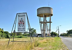
Theunissen is a small town that has the only wine estate, the Theunissen Wine Farm, in the Free State province of South Africa. It is located about 95 kilometers northeast of Bloemfontein and about 45 kilometers south of Welkom. It was founded by Boer War Commandant Helgaardt Theunissen. Theunissen has a small community which supports the local businesses.

Groblersdal is a farming town situated 32 km north of the 178 million m³ Loskop Dam in the Sekhukhune District of Limpopo.

Lichtenburg is a town situated in North West Province of South Africa. It is the administrative centre of Ditsobotla Local Municipality.

Emmarentia is a suburb of Johannesburg, South Africa.

Namakkal District is one of the 38 districts in the state of Tamil Nadu, India. The district was bifurcated from Salem District with Namakkal town as headquarters on 25 July 1996 and started to function independently from 1 January 1997. The district has seven taluks (subdivisions): Tiruchengode, Namakkal, Rasipuram, Paramathi-Velur, Sendamangalam, Kumarapalayam, Kolli Hills and Mohanur. It has two revenue divisions: Tiruchengode and Namakkal. As of 2011 census, Namakkal district had a population of 1,726,601 with a sex-ratio of 986 females for every 1,000 males and Tiruchengode is the largest city in terms of population. Namakkal district is geographically affiliated to Kongu Nadu region. to The district is famous for its large poultry industry, egg production and lorry body-building industry, for which it is often referred to as "Egg City" and "Transport Hub of South India".

Springbok is the largest town in the Namaqualand area in the Northern Cape province of South Africa. It was called Springbokfontein until 1911, when it was shortened to Springbok. Springbok is located on the N7 national route which connects the Cape with Namibia, and at the western end of the N14, which connects it with Upington and Pretoria. It is the main town of the Nama Khoi Local Municipality, which also includes a number of surrounding towns such as Okiep and Nababeep.

The Johannesburg Botanical Garden is located in the suburb of Emmarentia in Johannesburg, South Africa. The gardens grew out of a large rose garden that was established in 1964 and subsequently expanded from 1969 to cover an area of around 125 hectares (1.25 km2). It is administered by Johannesburg City Parks. The Emmarentia Dam is situated immediately to the east of the garden and shares its extensive acreage. One of the main attractions is the Rose Garden with over 10 000 roses.

The Gundlakamma River is a seasonal waterway that flows through the east-central part of the state of Andhra Pradesh, India. It arises in the Nallamalla Hills, an offshoot of the Eastern Ghats. Its main headwaters lie some 6 kilometers from the village of Ardhaveedu, Prakasam District at an altitude of 425 m. above MSL. Numerous mountain streams join it as it descends down the thickly forested hills through a series of curves and tight bends. It follows a north-easterly direction and enters the plains near Cumbum, after flowing through a town named after it. Gundlakamma is the largest of all the rivers that originate from the Nallamalla Hills.

Emmarentia Dam is a dam in Emmarentia, Johannesburg, South Africa. There are several dams that make up Emmarentia Dam, despite its allusion to the singular, with two small dams found upstream in the Johannesburg Botanical Gardens.

Kuttiady is a Town in the northern part of Kozhikode district in North Malabar region Kerala state, India. It is 24 km from Vatakara and 13 km from Perambra.

Marikana, formerly known as Rooikoppies, 'Marikana' is botched version of the name of a river in the land of Bapo called 'Maretlwane'. It a platinum mining town, the home of the then Lonmin, now Sibanye, in the Rustenburg local municipality, Bojanala Platinum District Municipality district in the North West province of South Africa.
Ngondoma Irrigation Scheme is located in Zhombe, Kwekwe District in Zimbabwe's Agro-Ecological Region Three. The average annual rainfall for the location is 550 mm. The scheme area is 44.4 4 hectares. Of the 179 farmers in the scheme, 134 are women. It comprises members from various villages, including villagers from Chief Njelele side, Gokwe District on the other side of Ngondoma River.

Westdene is a suburb of Johannesburg, South Africa. Westdene lies between the historic suburb of Sophiatown and Melville with the Melville Koppies West nature reserve to the north of the suburb. Westdene derives its name from its location, literally meaning west-valley. 'West' since it is located west from the city centre and with 'dene' derived from the Old English denu, meaning valley.