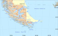
The Magallanes Region, officially the Magallanes y la Antártica Chilena Region, is one of Chile's 16 first order administrative divisions. It is the southernmost, largest, and second least populated region of Chile. It comprises four provinces: Última Esperanza, Magallanes, Tierra del Fuego, and Antártica Chilena.

Antártica Chilena Province is the southernmost of the four provinces in Chile's southernmost region, Magallanes and Antártica Chilena Region (XII). The capital is Puerto Williams. The province comprises the extreme southern part of Isla Grande de Tierra del Fuego, the islands south and west of Isla Grande, and Chile's claims in Antarctica. The province is administratively divided into two communes (comunas): Cabo de Hornos, located at the southern tip of South America, and Antártica, a wedge-shaped claim of Antarctica, which is not internationally recognized. Its total area of 1,265,853.7 km2 (488,749 sq mi) makes it almost twice as large as all other provinces of Chile combined.
Cerro is Spanish for "hill" or "mountain".

Puerto Natales is a city in Chilean Patagonia. It is the capital of both the commune of Natales and the province of Última Esperanza, one of the four provinces that make up the Magallanes and Antartica Chilena Region in the southernmost part of Chile. Puerto Natales is the only city in the province. It is located 247 km (153 mi) northwest of Punta Arenas. It is the final passenger port of call for the Navimag ferry sailing from Puerto Montt into the Señoret Channel as well as the primary transit point for travellers to Torres del Paine National Park, Chile.

The Tehuelche people, also called the Aónikenk, are an Indigenous people from eastern Patagonia in South America. In the 18th and 19th centuries the Tehuelche were influenced by Mapuche people, and many adopted a horseriding lifestyle. Once a nomadic people, the lands of the Tehuelche were colonized in the 19th century by Argentina and Chile, gradually disrupting their traditional economies. The establishment of large sheep farming estates in Patagonia was particularly detrimental to the Tehuelche. Contact with outsiders also brought in infectious diseases ushering deadly epidemics among Tehuelche tribes. Most existing members of the group currently reside in cities and towns of Argentine Patagonia.
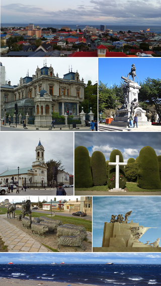
Punta Arenas is the capital city of Chile's southernmost region, Magallanes and Antarctica Chilena. Although officially renamed as Magallanes in 1927, the name was changed back to Punta Arenas in 1938. The city is the largest south of the 46th parallel south and the most populous southernmost city in Chile and the Americas. Due to its location, it is also the coldest coastal city with more than 100,000 inhabitants in Latin America. Punta Arenas is one of the world's most southerly ports and serves as an Antarctic gateway city. Punta Arenas is the world's southernmost city with more than 100,000 inhabitants and claims the title of southernmost city in the world, although this title is also claimed by Ushuaia in Argentina, which lies farther south but is slightly smaller than Punta Arenas.

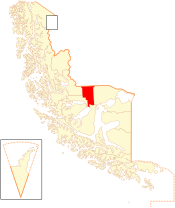
Magallanes Province is one of four provinces in the southern Chilean region of Magallanes and Antártica Chilena. The provincial capital is the city of Punta Arenas.

Ubalá is a municipality and town of Colombia in the department of Cundinamarca. It is located in the Eastern Ranges of the Colombian Andes. It is the only municipality of Cundinamarca that is split in two parts.
Cabo de Hornos is a Chilean commune located in the south of Tierra del Fuego archipelago, in Antártica Province, Magallanes Region. The municipality of Cabo de Hornos, located in the town of Puerto Williams, also administers the Antártica commune. It is named for Cabo de Hornos, or "Cape Horn", the southern tip of South America.

Torres del Paine is a Chilean commune located in the inland of Última Esperanza Province and Magallanes Region. The commune is administered by the municipality in Cerro Castillo, the major settlement in the commune. Torres del Paine National Park lies within the commune. Paine means "blue" in the native Tehuelche (Aonikenk) language and is pronounced PIE-nay.

Laguna Blanca is a Chilean commune located in Magallanes Province and Region. The commune is administered by the municipality in Villa Tehuelches, that is the major settlement in the whole commune.
Scottish Chileans are Chileans of Scottish descent who came from Scotland and, in some cases, Scots-Irish people from Northern Ireland. A large proportion of Scottish Chileans are sheep farmers in the Magallanes region of the far south of the country, and the city of Punta Arenas has a large Scottish foundation dating back to the 18th century.

Navimag is a ferry operator in Chile. The company operates two routes carrying passengers and vehicles:

The Chilean highway Route 9 (9-CH) runs from the Brunswick Peninsula south of Punta Arenas north to Paso Baguales Oriental at the border with Argentina in Torres del Paine commune. Route 9-CH is the main highway of Magallanes y la Antártica Chilena Region, and to travel between Route 9-CH and Chilean highways north of Magallanes y la Antártica Chilena Region vehicles have to pass through Argentina.
Tehuelche or Tehuelches may refer to:

Carolina Nevenka Goić Borojević is a Chilean politician who served as president of the Chilean Christian Democratic Party (PDC) from 2016 to 2017.

The schooner Ancud was the ship sent by Chile in 1843 to claim sovereignty over the Strait of Magellan and establish Fuerte Bulnes, the first Chilean settlement in the strait. It was built for the purpose in the city of San Carlos de Ancud and commanded by John Williams Wilson, a British-born Chilean captain.

Antártica is a Chilean commune in Antártica Chilena Province, Magallanes y la Antártica Chilena Region, which covers all the Chilean Antarctic Territory. It ranges from 53°W to 90°W and from the South Pole to 60°S, overlapping the Argentine and British Antarctic claims, and is the largest and least populated commune in Chile, being over 25 times the size of the next largest commune, Natales. It is administered by the Cabo de Hornos municipality in the South American mainland.
The Chilean takeover of the Strait of Magellan began in 1843 when an expedition founded Fuerte Bulnes. In 1848 the settlement of Punta Arenas was established further north in the strait and grew eventually to become the main settlement in the strait, a position it holds to this day. The Chilean settlement of the strait was crucial to establish its sovereignty claims in the area. Argentina complained diplomatically this act in 1847, as part of the East Patagonia, Tierra del Fuego and Strait of Magellan Dispute, and once the dispute was settled, formally recognised Chilean sovereignty of the strait in 1881. The Magallanes territory was made a regular Chilean province in 1928.
Centro Experimental Kampenaike is an experimental farm in Magallanes Region owned and operated by Instituto de Investigación Agropecuaria (INIA). It is located about 60 km northeast of Punta Arenas and hosts the southernmost certified potato farm in World. It is one of the two farms in operated by INIA Kampenaike, the local branch of INIA, the other is farm is a demonstrative unit in Puerto Natales.