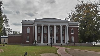
Surry County is a county in the Commonwealth of Virginia. As of the 2020 census, the population was 6,561.

The Jamestown Ferry is a free automobile and bus ferry service across a navigable portion of the James River in Virginia. It carries State Route 31, connecting Jamestown in James City County with Scotland Wharf in Surry County.

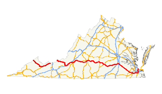
State Route 10 is a primary state highway in the U.S. state of Virginia. The state highway runs 93.58 miles (150.60 km) from U.S. Route 360 in Richmond east to SR 337 in Suffolk. SR 10 is a major suburban highway through Chesterfield County between the Southside of Richmond and Hopewell. Between Hopewell and Smithfield, which is served by SR 10 Business, the state highway passes through rural Prince George, Surry, and Isle of Wight counties, following the route of an old stagecoach road through an area that features many of the preserved James River plantations. SR 10 runs concurrently with US 258 and SR 32 between Smithfield and Suffolk.

State Route 5 runs between the independent cities of Richmond and Williamsburg in the U.S. state of Virginia. Between Charles City County and James City County, it crosses the Chickahominy River via the Judith Stewart Dresser Bridge, a fixed-span bridge which replaced historic Barrett's Ferry and the former drawbridge.

Transportation in the Commonwealth of Virginia is by land, sea and air. Virginia's extensive network of highways and railroads were developed and built over a period almost 400 years, beginning almost immediately after the founding of Jamestown in 1607, and often incorporating old established trails of the Native Americans.

Scotland also known as Scotland Wharf is a census-designated place (CDP) in Surry County, Virginia, United States. The population as of the 2010 Census was 203. Located on State Route 31, Scotland is the southern terminus and headquarters of the Jamestown Scotland Ferry, a crossing service of the James River operated by the Virginia Department of Transportation (VDOT).

State Route 114 is a primary state highway in the U.S. state of Virginia. Known as Peppers Ferry Road, the state highway runs 10.32 miles (16.61 km) from U.S. Route 11 in Fairlawn east to US 460 in Christiansburg. SR 114 is the northernmost of three east–west highways between Radford and Christiansburg and the most direct highway between Radford and Blacksburg. The state highway also connects those cities with the Radford Army Ammunition Plant.
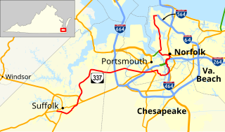
State Route 337 is a primary state highway in the South Hampton Roads area of the U.S. state of Virginia. It runs east from Suffolk to Portsmouth, where it crosses Jordan Bridge. It continues on the east side of the Southern Branch Elizabeth River in the South Norfolk neighborhood of Chesapeake. There it turns north, through Norfolk, crossing the Berkley Bridge into downtown, and ending at the Naval Station Norfolk at Sewell's Point. Most of its length was formed when other highways were rerouted: U.S. Route 460 from Suffolk to South Norfolk, SR 170 from South Norfolk to downtown Norfolk, and US 17 from downtown Norfolk to Sewell's Point. SR 337 is the only numbered highway to cross all three Branches of the Elizabeth River. It crosses the Western Branch as Portsmouth Boulevard at the Hodges Ferry Bridge, the Southern Branch on the Jordan Bridge, and the Eastern Branch on the Berkley Bridge. The Berkley Bridge is a drawbridge. SR 337 also crosses the Lafayette River in the city of Norfolk.

Williamsburg Area Transit Authority (WATA) is a multi-jurisdiction transportation agency providing transit bus and ADA Paratransit services in the City of Williamsburg, James City County, York County in the Historic Triangle area and Surry County, VA of the Virginia Peninsula subregion of Hampton Roads in southeastern Virginia.

State Route 72 is a primary state highway in the southwest part of the U.S. state of Virginia. It runs from SR 71 in Gate City north to SR 65 at Fort Blackmore, northeast with SR 65 to Dungannon, and north via Coeburn to SR 83 near Clintwood.

State Route 67 is a primary state highway in the southwest part of the U.S. state of Virginia. It runs from SR 80 near Honaker east to U.S. Route 460 at Raven, east concurrently with US 460 and US 460 Business into downtown Richlands, and north to SR 616 at Jewell Ridge on the Tazewell–Buchanan county line.
U.S. Route 460 (US 460) in Virginia runs west-east through the southern part of the Commonwealth. The road has two separate pieces in Virginia, joined by a relatively short section in West Virginia. Most of US 460 is a four-lane divided highway and is a major artery in the southern third of the state. From Petersburg to Suffolk, US 460 is a four-lane non-divided highway. It is a popular alternative to Interstate 64 (I-64) when going from Richmond and other points in central Virginia to the Currituck Sound and Outer Banks of North Carolina, avoiding the congestion and tunnels of the more northerly I-64 corridor. The road passes through several small towns that built up at stops along the railroad line. Two of these, Windsor and Waverly, have earned reputations for being speed traps.

State Route 16 is a primary state highway in the southwest part of the U.S. state of Virginia. It runs from the North Carolina border at North Carolina Highway 16 north to the West Virginia border at West Virginia Route 16, passing through the towns of Troutdale, Marion, and Tazewell. Highway 16 is part of a three-state route 16 that connects the Charlotte region with northwestern West Virginia.

State Route 13 is a primary state highway in the U.S. state of Virginia. Known as Old Buckingham Road, the state highway runs 24.08 miles (38.75 km) from U.S. Route 60 and SR 45 in Cumberland east to US 60 in Plain View. SR 13 parallels US 60 to the south through eastern Cumberland County and western Powhatan County and passes through the latter county's seat of Powhatan. The state highway is the only state-numbered highway in Virginia that shares a number with a U.S. Highway but does not form a state-numbered extension of that U.S. Highway. SR 13's number comes from being a segment of the original cross-state SR 13 in 1918; that highway included portions of modern US 60. In 1933, US 60 was shifted to its present corridor between Buena Vista and Richmond, replacing SR 13. Two years later, SR 13 was assigned to Old Buckingham Road when US 60 was moved to its present alignment from Cumberland to east of Powhatan.

Historically, the harbor was the key to the Hampton Roads area's growth, both on land and in water-related activities and events. Ironically, the harbor and its tributary waterways were both important transportation conduits and obstacles to other land-based commerce and travel. For hundreds of years, state and community leaders have worked to develop solutions to accommodate both.
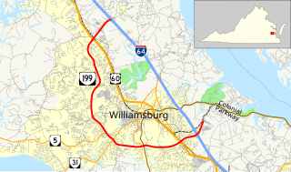
State Route 199 is a primary state highway in the U.S. state of Virginia. Known for most of its length as Humelsine Parkway, the state highway runs 14.13 miles (22.74 km) from Interstate 64 (I-64) and SR 646 in Lightfoot to SR 641 near Williamsburg. VA 199 forms a western loop of Williamsburg in York and James City Counties. The state highway, which is entirely a four-lane limited-access highway with a mix of intersections and interchanges, provides access from I-64 to several highways that serve attractions around Williamsburg, including U.S. Route 60 and Colonial Parkway, an automobile parkway that leads to Colonial Williamsburg, Jamestown, and Yorktown. VA 199 between its junctions with I-64 is named for Carlisle H. Humelsine, a former curator and president of Colonial Williamsburg, in 2004.


