The Moderate Resolution Imaging Spectroradiometer (MODIS) is a satellite-based sensor used for earth and climate measurements. There are two MODIS sensors in Earth orbit: one on board the Terra satellite, launched by NASA in 1999; and one on board the Aqua satellite, launched in 2002. MODIS has now been replaced by the VIIRS, which first launched in 2011 aboard the Suomi NPP satellite.
The Advanced Very-High-Resolution Radiometer (AVHRR) instrument is a space-borne sensor that measures the reflectance of the Earth in five spectral bands that are relatively wide by today's standards. AVHRR instruments are or have been carried by the National Oceanic and Atmospheric Administration (NOAA) family of polar orbiting platforms (POES) and European MetOp satellites. The instrument scans several channels; two are centered on the red (0.6 micrometres) and near-infrared (0.9 micrometres) regions, a third one is located around 3.5 micrometres, and another two the thermal radiation emitted by the planet, around 11 and 12 micrometres.

NOAA-19, known as NOAA-N' before launch, is the last of the American National Oceanic and Atmospheric Administration (NOAA) series of weather satellites. NOAA-19 was launched on 6 February 2009. NOAA-19 is in an afternoon Sun-synchronous orbit and is intended to replace NOAA-18 as the prime afternoon spacecraft.

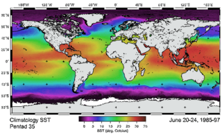
Ocean color is the branch of ocean optics that specifically studies the color of the water and information that can be gained from looking at variations in color. The color of the ocean, while mainly blue, actually varies from blue to green or even yellow, brown or red in some cases. This field of study developed alongside water remote sensing, so it is focused mainly on how color is measured by instruments.

NOAA-17, also known as NOAA-M before launch, was an operational, polar orbiting, weather satellite series operated by the National Environmental Satellite Service (NESS) of the National Oceanic and Atmospheric Administration (NOAA). NOAA-17 also continued the series of Advanced TIROS-N (ATN) spacecraft begun with the launch of NOAA-8 (NOAA-E) in 1983 but with additional new and improved instrumentation over the NOAA A-L series and a new launch vehicle.

NOAA-16, also known as NOAA-L before launch, was an operational, polar orbiting, weather satellite series operated by the National Environmental Satellite Service (NESS) of the National Oceanic and Atmospheric Administration (NOAA). NOAA-16 continued the series of Advanced TIROS-N (ATN) spacecraft that began with the launch of NOAA-8 (NOAA-E) in 1983; but it had additional new and improved instrumentation over the NOAA A-K series and a new launch vehicle. It was launched on 21 September 2000 and, following an unknown anomaly, it was decommissioned on 9 June 2014. In November of 2015 it broke up in orbit, creating more than 200 pieces of debris.

NOAA-18, also known as NOAA-N before launch, is an operational, polar orbiting, weather satellite series operated by the National Environmental Satellite Service (NESS) of the National Oceanic and Atmospheric Administration (NOAA). NOAA-18 also continued the series of Advanced TIROS-N (ATN) spacecraft begun with the launch of NOAA-8 (NOAA-E) in 1983 but with additional new and improved instrumentation over the NOAA A-M series and a new launch vehicle. NOAA-18 is in an afternoon equator-crossing orbit and replaced NOAA-17 as the prime afternoon spacecraft.

NOAA-15, also known as NOAA-K before launch, is an operational, polar-orbiting of the NASA-provided Television Infrared Observation Satellite (TIROS) series of weather forecasting satellite operated by National Oceanic and Atmospheric Administration (NOAA). NOAA-15 was the latest in the Advanced TIROS-N (ATN) series. It provided support to environmental monitoring by complementing the NOAA/NESS Geostationary Operational Environmental Satellite program (GOES).
NOAA-13, also known as NOAA-I before launch, was an American weather satellite operated by the National Oceanic and Atmospheric Administration (NOAA). NOAA-I continued the operational, polar orbiting, meteorological satellite series operated by the National Environmental Satellite System (NESS) of the National Oceanic and Atmospheric Administration (NOAA). NOAA-I continued the series (fifth) of Advanced TIROS-N (ATN) spacecraft begun with the launch of NOAA-8 (NOAA-E) in 1983. NOAA-I was in an afternoon equator-crossing orbit and was intended to replace the NOAA-11 (NOAA-H) as the prime afternoon (14:00) spacecraft.

NOAA-7, known as NOAA-C before launch, was an American operational weather satellite for use in the National Operational Environmental Satellite System (NOESS) and for the support of the Global Atmospheric Research Program (GARP) during 1978-1984. The satellite design provided an economical and stable Sun-synchronous platform for advanced operational instruments to measure the atmosphere of Earth, its surface and cloud cover, and the near-space environment. An earlier launch, NOAA-B, was scheduled to become NOAA-7, however NOAA-B failed to reach its required orbit.
NOAA-6, known as NOAA-A before launch, was an American operational weather satellite for use in the National Operational Environmental Satellite System (NOESS) and for the support of the Global Atmospheric Research Program (GARP) during 1978-1984. The satellite design provided an economical and stable Sun-synchronous platform for advanced operational instruments to measure the atmosphere of Earth, its surface and cloud cover, and the near-space environment.
NOAA B was an American operational weather satellite for use in the National Operational Environmental Satellite System (NOESS) and for the support of the Global Atmospheric Research Program (GARP) during 1978-1984. The satellite design provided an economical and stable Sun-synchronous platform for advanced operational instruments to measure the atmosphere of Earth, its surface and cloud cover, and the near-space environment.

Miguel Román, serves as Chief Climate Scientist and Technical Fellow at Leidos. A leading expert in the fields of satellite remote sensing, climate change, disaster risk reduction, and sustainability, Román has championed translational research and data-intensive approaches to assess and address climate-related risks. His work is internationally recognized for shedding light on the disproportionate hardships experienced by socially-vulnerable and underserved communities following major disasters.

The Joint Polar Satellite System (JPSS) is the latest generation of U.S. polar-orbiting, non-geosynchronous, environmental satellites. JPSS will provide the global environmental data used in numerical weather prediction models for forecasts, and scientific data used for climate monitoring. JPSS will aid in fulfilling the mission of the U.S. National Oceanic and Atmospheric Administration (NOAA), an agency of the Department of Commerce. Data and imagery obtained from the JPSS will increase timeliness and accuracy of public warnings and forecasts of climate and weather events, thus reducing the potential loss of human life and property and advancing the national economy. The JPSS is developed by the National Aeronautics and Space Administration (NASA) for the National Oceanic and Atmospheric Administration (NOAA), who is responsible for operation of JPSS. Three to five satellites are planned for the JPSS constellation of satellites. JPSS satellites will be flown, and the scientific data from JPSS will be processed, by the JPSS – Common Ground System (JPSS-CGS).

The Suomi National Polar-orbiting Partnership, previously known as the National Polar-orbiting Operational Environmental Satellite System Preparatory Project (NPP) and NPP-Bridge, is a weather satellite operated by the United States National Oceanic and Atmospheric Administration (NOAA). It was launched in 2011 and is currently in operation.

NOAA-21, designated JPSS-2 prior to launch, is the second of the United States National Oceanic and Atmospheric Administration (NOAA)'s latest generation of U.S. polar-orbiting, non-geosynchronous, environmental satellites called the Joint Polar Satellite System. NOAA-21 was launched on 10 November 2022 and join NOAA-20 and Suomi NPP in the same orbit. Circling the Earth from pole-to-pole, it will cross the equator about 14 times daily, providing full global coverage twice a day. It was launched with LOFTID.
NOAA-20, designated JPSS-1 prior to launch, is the first of the United States National Oceanic and Atmospheric Administration's latest generation of U.S. polar-orbiting, non-geosynchronous, environmental satellites called the Joint Polar Satellite System. NOAA-20 was launched on 18 November 2017 and joined the Suomi National Polar-orbiting Partnership satellite in the same orbit. NOAA-20 operates about 50 minutes behind Suomi NPP, allowing important overlap in observational coverage. Circling the Earth from pole-to-pole, it crosses the equator about 14 times daily, providing full global coverage twice a day. This gives meteorologists information on "atmospheric temperature and moisture, clouds, sea-surface temperature, ocean color, sea ice cover, volcanic ash, and fire detection" so as to enhance weather forecasting including hurricane tracking, post-hurricane recovery by detailing storm damage and mapping of power outages.

NOAA-8, known as NOAA-E before launch, was an American weather satellite operated by the National Oceanic and Atmospheric Administration (NOAA) for use in the National Environmental Satellite Data and Information Service (NESDIS). It was first of the Advanced TIROS-N series of satellites. The satellite design provided an economical and stable Sun-synchronous platform for advanced operational instruments to measure the atmosphere of Earth, its surface and cloud cover, and the near-space environment.
NOAA-11, known as NOAA-H before launch, was an American weather satellite operated by the National Oceanic and Atmospheric Administration (NOAA) for use in the National Operational Environmental Satellite System (NOESS) and for support of the Global Atmospheric Research Program (GARP) during 1978–1984. It was the fourth of the Advanced TIROS-N series of satellites. The satellite design provided an economical and stable Sun-synchronous platform for advanced operational instruments to measure the atmosphere of Earth, its surface and cloud cover, and the near-space environment.
NOAA-14, also known as NOAA-J before launch, was an American weather satellite operated by the National Oceanic and Atmospheric Administration (NOAA). NOAA-14 continued the third-generation operational, Polar Orbiting Environmental Satellite (POES) series operated by the National Environmental Satellite Service (NESS) of the National Oceanic and Atmospheric Administration (NOAA). NOAA-14 continued the series of Advanced TIROS-N (ATN) spacecraft begun with the launch of NOAA-8 (NOAA-E) in 1983.
