Sonbhadra or Sonanchal is the second largest district by area of Uttar Pradesh after Lakhimpur Kheri. It is the only district in India which borders four states, namely Madhya Pradesh to the west, Chhattishgarh to the south, Jharkhand in the south-east and Bihar to the north-east. The district has an area of 6,788 km2 (2,621 sq mi) and a population of 1,862,559, with a population density of 270 inhabitants per square kilometre (700/sq mi). It lies in the extreme south-east of the state, and is bounded by Mirzapur district to the northwest, Chandauli district to the north, Kaimur and Rohtas districts of Bihar state to the north-east, Garhwa district of Jharkhand state to the east, Balrampur District of Chhattisgarh state to the south, and Singrauli district of Madhya Pradesh state to the west. The district headquarters is in the town of Robertsganj. Sonbhadra district is an industrial zone and it has much bauxite, limestone, coal, gold, etc. It is called the "Energy Capital of India" because there are multiple power plants.
Sidhi is a town and a municipality in Sidhi district in the Indian state of Madhya Pradesh. It is the headquarters of the Sidhi district.
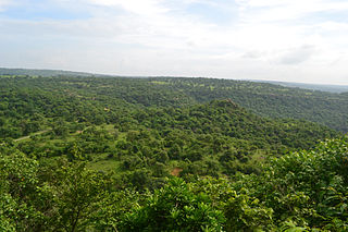
Dudhi or Duddhi is a town and & Nagar panchayat in Sonbhadra district in the state of Uttar Pradesh, India. It belongs to Mirzapur Division. It is located 64 km south of the district capital, Robertsganj. Dudhi is a tehsil of sonebhadra district. Renukoot, Anpara, Obra, Robertsganj are the nearby Cities to Dudhi. Dudhinagar-Renukoot is demanded district by dudhinagar people. There are many places to visit and enjoy natural beauty and environment of this town. This has hidden tourism site as locals have named one site as "Mini Goa" people visit this place to celebrate New year. Locals are very friendly.

Musafirkhana is a town and tehsil in Amethi district in Indian state of Uttar Pradesh. The word "Musafirkhana" means "Sarai," or "Dharamshala". Musafirkhana is located 32 km northwest of Amethi, 20 km from Jagdishpur. Gauriganj and Amethi are accessible from Musafirkhana via roadways; the nearest railway station is the Musafirkhana railway station on the Lucknow–Varanasi rail route via Sultanpur, and the nearest airport is the Amausi airport. It is surrounded by more than 100 villages. The town is between 26.37° north latitude and 81.8° east longitude at a height of 102 metres (434 feet) above mean sea level.
Rithora is a town and a nagar panchayat in Bareilly Tehsil of Bareilly district in the Indian state of Uttar Pradesh.

Kishtwar district is a district of the Indian union territory of Jammu and Kashmir. As of 2011, it is the largest and the least populous district of Jammu and Kashmir.

Singrauli district is one of the districts in the Indian state of Madhya Pradesh.
The Haveli Tehsil is a tehsil of the Poonch district in the Indian union territory of Jammu and Kashmir. It is headquartered at the Poonch Town.
Muirpur Airport also spelled as Myorpur Airport is an upcoming airport, situated at Muirpur approx 12 km from the Renukut in the Sonbhadra district in the Indian state of Uttar Pradesh. Airport is developing by upgrading the existing government airstrip. It will serves nearby towns, Northern Coalfields Limited (NCL) ,NTPC projects Renukut and Robertsganj, the Other towns of Sonbhadra and Singrauli district. The airport will serve the region which has many electrical power stations, known as "Energy Capital of India". It’s 26.5 km away from DUDHI TEHSIL.
Nipaniya is a village in Beohari Tehsil in Shahdol District of Madhya Pradesh State, India. It belongs to Shahdol Division. It is located 95 km north of the district headquarters of Shahdol, 31 km from Beohari Tehsil and 454 km from the State capital, Bhopal.
Deosar (Devsar) is a town and tehsil in Singrauli district, Madhya Pradesh, India. It is also an industrial hub. Deosar Tehsil is located on N.H. 39. It is also a Madhya Pradesh Legislative Assembly, part of the Sidhi Lok Sabha constituency.

Mendhar is a tehsil in the Poonch district of the Indian union territory of Jammu and Kashmir. It is located in the foothills of Pir Panjal range within the Himalayas. The Mendhar Tehsil headquarters is in Mendhar town. It is located 60 km (37 mi) south of the Poonch district headquarters and 210 km (130 mi) from the state winter capital Jammu.

Madhupur is a census town in Sonbhadra district in the Indian state of Uttar Pradesh. It is located 17 km from Robertsganj which is the administrative headquarters of Sonbhadra District. The district Sonbhadra was created by carving off the southern part of the earlier Mirzapur district on 4 March 1989. Son, Karmnasha, Chandra Prabha, Rihand, Kanhar, Renu, Ghagar and Belan Rivers drain this area. in which Son River in main.
Pakhanjur, also known as Pakhanjore, is a town, nagar panchayat, and the headquarters of the eponymous tehsil in the Kanker District, Chhattisgarh, India. It is located 10 km (6.2 mi) south-west of Kapsi, the forest range headquarters; 47 km (29 mi) west of Koyalibeda, the block headquarters; and 120 km (75 mi) south-west of Kanker, the district headquarters. Its distance is 72 km (45 mi) from Bhanupratappur, 190 km (120 mi) from Durg and 250 km (160 mi) from the state capital Raipur.

Saifai is a large village and university town in the Etawah district of Indian state of Uttar Pradesh. It is also a sub-division (Tehsil) and Block of the Etawah district. It is the birthplace of Mulayam Singh Yadav, the founding president of Samajwadi Party, former Minister of Defence, India and former Chief Minister of Uttar Pradesh.
Ramgarh is a medium size village in Phillaur tehsil of Jalandhar District of Punjab State, India. It is located 1 km away from postal head office Phillaur, 16 km from Ludhiana, 45 km from district headquarter Jalandhar and 118 km from state capital Chandigarh. The village is administrated by a sarpanch who is an elected representative of village as per Panchayati raj (India).
Bainapur is a small size village in Phillaur tehsil of Jalandhar district of Punjab State, India. It is located 25 km away from Phillaur, 5.8 km from Nurmahal, 27.7 km from district headquarter Jalandhar and 147 km from state capital Chandigarh. The village is administrated by a sarpanch who is an elected representative of village as per Panchayati raj (India).
Bahari is a tehsil and a village panchayat in Sidhi district in the Indian state of Madhya Pradesh. Bhopal is the state capital for Bahari village. It is located around 587 km from Bahari. The other nearest state capital from Bahari is Lucknow and its distance is 385.1 km. The other surrounding state capitals are Patna 442.7 km and Ranchi 416.6 km
Takha is a village in the Etawah district Uttar Pradesh. It is also a Sub-Division (Tehsil) and Block of the Etawah district.
Surankote Tehsil is a tehsil of the Poonch district in the Indian union territory of Jammu and Kashmir. It is headquartered at the Surankote.
