
Haridwar is a city and municipal corporation in the Haridwar district of Uttarakhand, India. With a population of 228,832 in 2011, it is the second-largest city in the state and the largest in the district.
Wardha is a city and a municipal council in Wardha district in the Indian state of Maharashtra. The administrative headquarter of Wardha district is situated here. Wardha gets its name from the Wardha River which flows on the northern, western and southern boundaries of the district. Founded in 1866, the town is now an important centre for cotton trade. Wardha was an important part of the Gandhian era.
Banswara is a city in the Banswara district in southern Rajasthan, India. The name, Banswara, came from king ‘Bansiya Bhil’

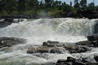
Rewa district is a district of the Madhya Pradesh state in central India. The city of Rewa is the district headquarter. Rewa is sometimes called the "Land of White Tigers", as the first White Tiger was discovered here in 1951 by the Maharaja of the province, Martand Singh, in the nearby jungle of Govindgarh. Rewa was the capital city of a former state, Vindhya Pradesh.

Shahdol District is a district of Madhya Pradesh state in east central India. It old name was Matsya raj or Virat kingdom in the name of great king Maharaja Virata. With a total area of 6,205 km2 (2,396 sq mi) and a population of 10,66,063. Shahdol is an important district of Madhya Pradesh. The town of Shahdol is the district headquarters. The district formerly comprised Shahdol division.
Umaria district is a district of Madhya Pradesh. The town of Umaria is the district headquarters. The district is part of Shahdol Division.

Satna is a city in the Indian state of Madhya Pradesh. It serves as the headquarters of Satna district. It is 7th largest city and 8th most populous city of the state. The city is 500 km east of the state capital Bhopal. The city is distributed over a land area of 111.9 square kilometres.
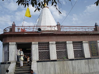
Maihar is a city in the Maihar district of the Indian state of Madhya Pradesh. It's Administrative Headquarter of Maihar District. Maihar is known for the Maa Sharda Mandir situated in the city.
Ashoknagar District is a district of Madhya Pradesh state in central India. The city of Ashoknagar is the administrative headquarters of the district. Ashoknagar district was formed in 2003.

Mandi Bamora is a census town in Sagar district in the state of Madhya Pradesh, India. This place has a railway station Mandi Bamora. Mandi Bamora located as half- half way in two different district Sagar and Vidisha. Tehsil is Bina. Mandi Bamora is very famous as a name "Great country" because two different districts boundaries separated two places Bamora and Sihora.
Chandia is a town and a nagar parishad, near Umaria town in Umaria district in the state of Madhya Pradesh, India.
Chitrakoot Dham is a city in the Chitrakoot district, in the Indian state of Uttar Pradesh. It is the headquarters of the Chitrakoot district. Situated in the Bundelkhand region, it holds great cultural, historical, religious and archaeological importance and it is said that Rama, a major deity in Hinduism, spent 11 years of exile in Chitrakoot. It is connected to the town of Chitrakoot, situated in the Satna district of Madhya Pradesh.

Mauganj is the administrative headquartet of Mauganj district in Madhya Pradesh. Bagheli is the regional language of Mauganj. Mauganj is the seat of legislative assembly in Madhya Pradesh. Its nearest towns are Manikwar, Hanumana, Deotalab, Naigadhi.

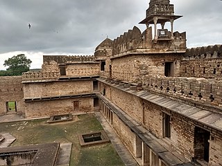
Naigarhi is a rural town in the Rewa district of Madhya Pradesh, India. It was founded by a Sengar Rajput king, Raja Chattradhari Singh. The town is notable for its medieval era architecture constructed by the Sengar kings.

Newai or Niwai is a town, and a municipality and tehsil in Tonk district in the Indian state of Rajasthan. The Tonk district is bounded in the north by Jaipur district, in the east by Sawai Madhopur district, in the southeast by Kota district, in the south by Bundi district, in the southwest by Bhilwara district, and in the west by Ajmer district. Jaipur, capital of Rajasthan is the closest major city to Newai. In 1783 Nepalia-Mathur Kayastha of Jaipur estate occupied it after defeating Nawab of Tonk in a bloody battle fought at the fort of Rakhtanchal fort. Since then it was a vassal state to the Jaipur estate until Jaipur became part of Independent India. Darbar of Daroga ji ruled Niwai under Maharaja of Jaipur.

Ramtek is a city and municipal council in Nagpur district of Maharashtra, India.
Teonthar is a town and a nagar panchayat in Rewa district in the Indian state of Madhya Pradesh.

Satna District is a district of Madhya Pradesh state in central India. The city of Satna is the district headquarters. The district has an area of 7,502 km2, and a population of 22,28,935(2011 census), 20.63% of which is urban. The district has a population density of 249 persons per km2.

Govindgarh, the summer capital of Mahraja Rewa, is about 18 km from Rewa in Madhya Pradesh, India. The is Rewa, with an area of about 13,000 mi², was the largest princely state in the Bagelkhand Agency and the second largest in Central India Agency. The British political agent for Bagelkhand resided at Satna, on the East Indian railway. The Bagelkhand capital establish in Rewa under the Rewa Maharaja.Bagheli is the local language of the region.It's neighbouring towns are Manikawar, Gurh and Rewa.
Hindaun is a Block in Karauli district of the Indian state of Rajasthan in Northern India. It is a subdivisional headquarter. Its population is approximately 442,000. The block covers an area of 700 Square kilometres, which makes it the biggest block in Karauli. The subdistrict code of Hindaun Block is 00522. There are about 165 villages in Hindaun Block.

