Nai Garhi

Last updated

Naigarhi
Naigarhi
Nai Garhi Hathi-Darwaza.jpg
Madhya Pradesh location map.svg
Red pog.svg
Naigarhi
Location in Madhya Pradesh, India
Coordinates: 24°47′15″N81°46′54″E / 24.78750°N 81.78167°E / 24.78750; 81.78167
CountryFlag of India.svg  India
State Madhya Pradesh
District Rewa
Founded byChattradhari Singh
Population
 (2001)
  Total9,767
Languages
  Official Hindi
Time zone UTC+5:30 (IST)
PIN
486340

Naigarhi is a rural town in the Rewa district of Madhya Pradesh, India. It was founded by a Sengar Rajput king, Raja Chattradhari Singh. The town is notable for its medieval era architecture constructed by the Sengar kings.

Contents

History

Thakur Gopal Sharan Singh of Nai Garhi, Madhya Pradesh Thakur Gopal Sharan Singh of Nai Garhi.jpg
Thakur Gopal Sharan Singh of Nai Garhi, Madhya Pradesh

The town of Nai Garhi which means a 'new fortress' was established by Raja Chattradhari Singh of Sengar dynasty. According to the history of the region, he was a scion of the Sengar clan of Rajputs that ruled over a kingdom known as Mauganj which was also known as 'Mau Raj'. The dynasty i s believed to have arrived from Jalaun (now in Uttar Pradesh) in the eleventh century and ruled as independent kings until fourteenth century. However, a new clan of Rajputs called Baghelas captured Mauganj from Sengars. They established their control in the region and named it as Bagelkhand. [1]

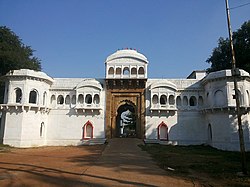
One of the Sengar scions was Raja Chattradhari Singh whose father being the junior prince migrated to Nai Garhi region, a few years before Mauganj was attacked by Baghelas. According to the bardic tales, the fort was first set to be built upon a land adjacent to the temple of Astha-bhuja (a varying form of goddess Durga) but the prince saw a dream where the goddess addressed him to move to a different location to maintain the sanctity of the temple and also advised him a suitable location. Therefore, that following morning he instructed his troops to spot a wild hare that was being chased by a wolf and the place where the wolf hunts the hare will be the sanctified location for the new fortress. The troops saw the exact sightings as discussed by the prince and ultimately found the location to build the fortress. The family chronicles state that the fortress was built by Raja Chattradhari Singh and the marvelous main gate known as the 'Hathi Darwaza' was built by his son Raja Hathi Raj Singh.

The rulers of this little but highly defensive kingdom maintained sovereign rule for a long period and used the title of Raja, however, they refrained from expanding their dominion any further due to the rising prowess of the Baghelas who established a cordial relationship with the Mughals and secured Bagelkhand by appointing numerous feudal lords. Essentially, the Sengars were able to maintain their sovereignty until the arrival of the British in the region.

Battle of Sathni and Itar

In 1812, a group of Pindaris raided Mirzapur territory which forced the then king of Rewa, Raja Jai Singh to accede to a treaty with the British Raj. This first Anglo-Baghela treaty (1812) brought dissatisfaction in the region mostly among the Sengar Rajputs who started aggression against the British. [2]

In 1813, one Colonel Martindell reported in the region with a unit of Sepoys to quell the insurgency. A number of sepoys were killed and wounded at the behest of the Sengar Thakur whose headquarters was based in the village of Itar near Manikwar town. This battle is still remembered in the folk song known as 'Itar ka Raisa'. [2] At some instance, the estate of Naigarhi was confiscated by the British who decided to reissue it to the then Thakur Jagat Bahadur Singh of Naigarhi, under one condition that the Thakur agreed to pay his dues and attended the Dussehara ceremonies held in the Rewa Durbar. Reportedly, the British also kidnapped Jagat Bahadur's eight-year-old son named Gopal Sharan Singh to get their work done. The Thakur agreed to pay off his dues and attended the Durbar of Rewa Maharaja. As a result, in 1882 the estate was re granted to the Sengar clan. [3]

Aftermath

The last ruler of Naigarhi was Thakur Gopal Sharan Singh. He was born in 1890 and went on to become a revered poet of Hindi poetry. The total worth of his estates were Rs. 90,000 per annum and an amount of Rs. 6,500 was paid to the Durbar. [4] He was awarded the title of 'Kavi Ratna' or the 'Gem among Poets'. [5] While residing in his Lal Kothi Mansion in Allahabad he build cordial relationships with great poets of his time like Maithili Sharan Gupt and Harivansh Rai Bachchan. The Higher Secondary School in Nai Garhi is named after him and every year a poet event is organised by the government in honor of Singh. The family of kunwar Suman Singh grandson of Thakur Gopal Sharan Singh live in naigarhi fort, Suman Singh had three children Sarika Singh who was married to the prince of Jeypore Odisha, Harshvardhan Singh and Yashvardhan Singh. Harshvardhan Singh ( Bablu Singh ) is active in politics of the area, he has a son named Kunwar Abhimanyu Singh and Yashvardhan Singh has two daughters, Kunwar Abhimanyu Singh recommenced the shastra pujan of Naigarhi Riyasat.

Politics

Naigarhi is under Deotalab vidhansabha. The first MLA of Deotalab was Thakur Someshvara Singh of Nagar high. Naigarhi also started holding the Municipality elections and Kunwar Harshvardhan Singh ( Bablu Bhaiya ) has won the election two times.

Education

Naigarhi has a two government schools, boys and girls separate. The other private schools are regional board affiliated, Hindi mediums are Saraswati Shishu Mandir, Saraswati Gyan Mandir, Jeevan Jyoti, and an only English medium school is Lok Manya Tilak High School in Mahavirpur. The only college is named after Thakur Someshvara Singh comprising the studies of Arts and Commerce.

Tourism

Panchamandir Temple in Nai Garhi fort Panchamandir Temple in Nai Garhi Fort.jpg
Panchamandir Temple in Nai Garhi fort

The tourism frequency of Naigarhi is very low due to its distance from highways. A couple of waterfalls, the most famous one in the small village of Bahuti which is some 5 km away from Naigarhi, the famous Maa Asthabhuja temple, the Naigarhi fort, the Panchmandir temple and the iconic view of a typical Indian village can be seen in Naigarhi.

Inside view of the Nai Garhi Fort The Fort of Nai Garhi.jpg
Inside view of the Nai Garhi Fort

The Panchamandir is dedicated to Rama who is the main deity of the Sengar dynasty, Hanuman and Shiva. It resembles the fine stone carving art of the medieval India. There is also a temple dedicated to the goddess Kali which is located within the fort and is a popular tourist destination.

Festivities and culture

Apart from Durga Pooja in Dussherra, Diwali and Holi there is no festival which is celebrated here. But the Naigarhi fort has a reputation for decorating and celebrating Janamasthami with grandeur and holiness. Naigarhi fort also organises a holy feast called 'bhandara' in respect to the renovation of the Pancha-mandir temple in the precincts of the fort.

Demographics

As of 2001 India census, [6] Nai Garhi had a population of 8,767. Males constitute 51% of the population and females 49%. Nai Garhi has an average literacy rate of 50%, lower than the national average of 59.5%: male literacy is 63%, and female literacy is 36%. In Nai Garhi, 19% of the population is under 6 years of age.

Transport

By air

Nearest airport in Prayagraj, Uttar Pradesh.

By bus

Bus stand available in the city bus stand Garhi.

By Train

Related Research Articles

<span class="mw-page-title-main">Bagelkhand</span> Region in Madhya Pradesh and Uttar Pradesh, India

Bagelkhand or Baghelkhand is a proposed state and a mountain range in central India that covers the northeastern regions of Madhya Pradesh and a small area of southeastern Uttar Pradesh.

<span class="mw-page-title-main">Central India Agency</span> Agency of princely states in India

The Central India Agency was created in 1854, by amalgamating the Western Malwa Agency with other smaller political offices which formerly reported to the Governor-General of India. The agency was overseen by a political agent who maintained relations of the Government of India with the princely states and influence over them on behalf of the Governor-General. The headquarters of the agent were at Indore.

<span class="mw-page-title-main">Rewa, Madhya Pradesh</span> City in Madhya Pradesh, India

Rewa is a city in the north-eastern part of Madhya Pradesh state in India. It is the administrative center of Rewa District and Rewa Division. The city lies about 420 kilometres (261 mi) northeast of the state capital Bhopal and 230 kilometres (143 mi) north of the city of Jabalpur. The maximum length of Rewa district is 125 km from east to west and the length of Rewa from north to south is 96 km. This area is surrounded by Kaimur hills to the south Vindhyachal ranges pass through the middle of the district.

<span class="mw-page-title-main">Rewa district</span> City and district of Madhya Pradesh in India

Rewa district is a district of the Madhya Pradesh state in central India. The city of Rewa is the district headquarter. Rewa is sometimes called the "Land of White Tigers", as the first White Tiger was discovered here in 1951 by the Maharaja of the province, Martand Singh, in the nearby jungle of Govindgarh. Rewa was the capital city of a former state, Vindhya Pradesh.

<span class="mw-page-title-main">Umaria district</span> District of Madhya Pradesh in India

Umaria district is a district of Madhya Pradesh. The town of Umaria is the district headquarters. The district is part of Shahdol Division.

<span class="mw-page-title-main">Satna</span> City in Madhya Pradesh, India

Satna is a city in the Indian state of Madhya Pradesh. It serves as the headquarters of Satna district. It is 7th largest city and 8th most populous city of the state. The city is 500 km east of the state capital Bhopal. The city is distributed over a land area of 111.9 square kilometres.

Sironj is a town and a municipality in Vidisha district in the Indian state of Madhya Pradesh. Its also a Tehsil Headquarter.

<span class="mw-page-title-main">Rewa (princely state)</span> Princely state in India

Rewa State, also known as Rewah, was a princely state of India, surrounding its eponymous capital, the town of Rewa.

Amarpatan is a municipal city in Maihar district in the state of Madhya Pradesh, India.

Chandia is a town and a nagar parishad, near Umaria town in Umaria district in the state of Madhya Pradesh, India.

<span class="mw-page-title-main">Mauganj</span> Town in Madhya Pradesh, India

Mauganj is the administrative headquartet of Mauganj district in Madhya Pradesh. Bagheli is the regional language of Mauganj. Mauganj is the seat of legislative assembly in Madhya Pradesh. Its nearest towns are Manikwar, Hanumana, Deotalab, Naigadhi.

Sabalgarh is a municipality in Morena district in the Indian state of Madhya Pradesh.

<span class="mw-page-title-main">Satna district</span> District of Madhya Pradesh in India

Satna District is a district of Madhya Pradesh state in central India. The city of Satna is the district headquarters. The district has an area of 7,502 km2, and a population of 22,28,935(2011 census), 20.63% of which is urban. The district has a population density of 249 persons per km2.

<span class="mw-page-title-main">Govindgarh, Madhya Pradesh</span> City in Madhya Pradesh, India

Govindgarh, the summer capital of Mahraja Rewa, is about 18 km from Rewa in Madhya Pradesh, India. The is Rewa, with an area of about 13,000 mi², was the largest princely state in the Bagelkhand Agency and the second largest in Central India Agency. The British political agent for Bagelkhand resided at Satna, on the East Indian railway. The Bagelkhand capital establish in Rewa under the Rewa Maharaja.Bagheli is the local language of the region.It's neighbouring towns are Manikawar, Gurh and Rewa.

Pentalisa was a territory which was located in the region of Shekhawati, India. The group of 45 villages under Udaipurwati was known as Pentalisa. The Bhojraj Ji Ka Shekhawat Rajputs ruled over two territories, Pentalisa and Panch Pana.

Sengar, also known as Sanghar, Singraur or Songar, are a king of Rajputs in India.

Raja Sangram Shah Madavi was a king of the Garha Kingdom of Gondwana, in the state of Madhya Pradesh, India. Raja Sangram Shah, who belonged to the Gond Dynasty in central India, was the 48th and most well known ruler of the dynasty, and during his reign he had conquered 52 forts to strengthen his kingdom. The Chouragarh Fort in Narsinghpur was built in his honour for conquering 52 forts.

<span class="mw-page-title-main">Nagod State</span> State in British India

Nagod State was a princely state of colonial India, located in modern Satna district of Madhya Pradesh. The state was known as 'Unchahara' after Unchehara, its original capital until the 18th century.

<span class="mw-page-title-main">Rajput architecture</span> Overview of the architecture by the Rajput rulers of Rajasthan

Rajput architecture is an architectural style associated with the forts and palaces of the many Rajput rulers. Many of the Rajput forts are UNESCO World Heritage Sites and popular tourist attractions.

<span class="mw-page-title-main">Mauganj district</span> District of Madhya Pradesh in India

Mauganj district is one the district of Madhya Pradesh. The administrative headquarter is at Mauganj. The district was carved out from existing Rewa district on 15 August 2023. The district was announced by then Chief Minister Shivraj Singh Chouhan.

References

  1. Baker, David E. U. (1 January 2007). Baghelkhand, Or, the Tigers' Lair: Region and Nation in Indian History. New York [N.Y.] ISBN   978-0-19-568321-9.
  2. 1 2 Siddiqui, A. U. (2004). Indian Freedom Movement in Princely States of Vindhya Pradesh. Northern Book Centre. ISBN   978-81-7211-150-2.
  3. Baker, David E. U. (1 January 2007). Baghelkhand, Or, the Tigers' Lair: Region and Nation in Indian History. New York [N.Y.] ISBN   978-0-19-568321-9.
  4. India, Central (1928). Rulers, Leading Families and Officials in the States of Central India. Government of India, Central Publication Branch.
  5. Proceedings and Transactions of the ... All-India Oriental Conference. 1935.
  6. "Census of India 2001: Data from the 2001 Census, including cities, villages and towns (Provisional)". Census Commission of India. Archived from the original on 16 June 2004. Retrieved 1 November 2008.