A geyser is a spring with an intermittent discharge of water ejected turbulently and accompanied by steam. The formation of geysers is fairly rare, and is caused by particular hydrogeological conditions that exist only in a few places on Earth.

Geysir, sometimes known as The Great Geysir, is a geyser in south-western Iceland, that geological studies suggest started forming about 1150 CE. The English word geyser derives from Geysir. The name Geysir itself is derived from the Icelandic verb geysa. Geysir lies in the Haukadalur valley on the slopes of Laugarfjall lava dome, which is also the home to Strokkur geyser about 50 metres (160 ft) to the south. The Strokkur geyser may be confused with it, and the geothermal field it is in is known usually as either, Geysir or Haukadalur.

The Pink and White Terraces, were natural wonders of New Zealand. They were reportedly the largest silica sinter deposits on Earth. They disappeared in the 1886 eruption of Mount Tarawera and were generally thought to have been destroyed, until evidence emerged in the early twenty-first century of their survival.
Rotorua is a city in the Bay of Plenty Region of New Zealand's North Island. It is sited on the southern shores of Lake Rotorua, from which it takes its name. It is the seat of the Rotorua Lakes District, a territorial authority encompassing Rotorua and several other nearby towns. It has an estimated resident population of 58,800, making it the country's 13th largest urban area, and the Bay of Plenty's second-largest urban area behind Tauranga.
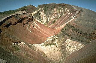
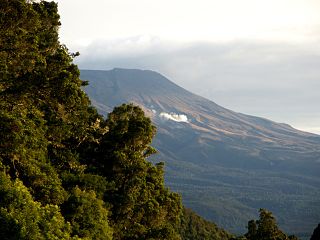
Mount Tarawera is a volcano on the North Island of New Zealand within the older but volcanically productive Ōkataina Caldera. Located 24 kilometres southeast of Rotorua, it consists of a series of rhyolitic lava domes that were fissured down the middle by an explosive basaltic eruption in 1886. While the 1886 eruption was basaltic, study has shown there was only a small basalt component to the previous recent rhyolitic predominant eruptions. This eruption was one of New Zealand's largest historical eruptions, and killed an estimated 120 people. The fissures run for about 17 kilometres (11 mi) northeast–southwest.

Te Wairoa was a village close to the shore of Lake Tarawera near Rotorua, New Zealand. The village was buried by volcanic ash in the 1886 eruption of Mount Tarawera. It was later excavated and is now open as a tourist destination, the Buried Village. The nearby Wairere Falls are also a tourist destination.

Lake Rotomahana is an 890-hectare (2,200-acre) lake in northern New Zealand, located 20 kilometres to the south-east of Rotorua. It is immediately south-west of the dormant volcano Mount Tarawera, and its geography was substantially altered by a major 1886 eruption of Mount Tarawera. Along with the mountain, it lies within the Ōkataina Caldera. It is the most recently formed larger natural lake in New Zealand, and the deepest in the Rotorua district.

Lake Rotorua is the second largest lake in the North Island of New Zealand by surface area, and covers 79.8 km2. With a mean depth of only 10 metres it is considerably smaller than nearby Lake Tarawera in terms of volume of water. It is located within the Rotorua Caldera in the Bay of Plenty Region.
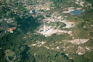
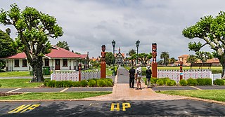
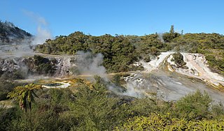
Whakarewarewa is a Rotorua semi-rural geothermal area in the Taupō Volcanic Zone of New Zealand. This was the site of the Māori fortress of Te Puia, first occupied around 1325, and known as an impenetrable stronghold never taken in battle. Māori have lived here ever since, taking full advantage of the geothermal activity in the valley for heating and cooking.
New Zealand has a large number of hot springs. Many of them are used for therapeutic purposes.
Orakei Korako is a highly active geothermal area most notable for its series of fault-stepped sinter terraces, located in a valley north of Taupō on the banks of the Waikato River in the Taupō Volcanic Zone, New Zealand. It is also known as "The Hidden Valley".
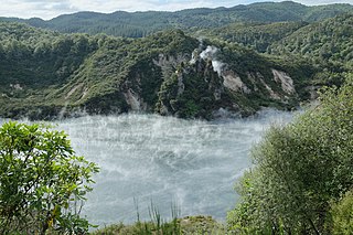
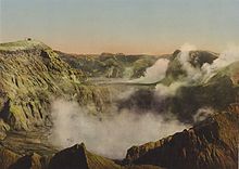
The Waimangu Volcanic Rift Valley is the hydrothermal system created on 10 June 1886 by the volcanic eruption of Mount Tarawera, on the North Island of New Zealand. It encompasses Lake Rotomahana, the site of the Pink and White Terraces, as well as the location of the Waimangu Geyser, which was active from 1900 to 1904. The area has been increasingly accessible as a tourist attraction and contains Frying Pan Lake, which is the largest hot spring in the world, and the steaming and usually pale blue Inferno Crater Lake, the largest geyser-like feature in the world although the geyser itself cannot be seen since it plays at the bottom of the lake.

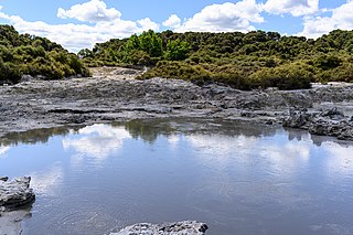
Frying Pan Lake is the world's largest hot spring. It is located in the Echo Crater of the Waimangu Volcanic Rift Valley, New Zealand and its acidic water maintains a temperature of about 50 to 60 °C (122–140 °F). The Lake covers 38,000 square metres in part of the volcanic crater and the shallow lake is only 5.5 metres (18 ft) deep, but at vents, it can go down to 18.3 metres (60 ft).

The geology of New Zealand is noted for its volcanic activity, earthquakes and geothermal areas because of its position on the boundary of the Australian Plate and Pacific Plates. New Zealand is part of Zealandia, a microcontinent nearly half the size of Australia that broke away from the Gondwanan supercontinent about 83 million years ago. New Zealand's early separation from other landmasses and subsequent evolution have created a unique fossil record and modern ecology.
Tikitere, also known as "Hell's Gate", is a suburb in Rotorua's most active geothermal area on State Highway 30, between Lake Rotorua and Lake Rotoiti in the Bay of Plenty, New Zealand. It includes many geothermal features such as steaming lakes, mudpools, fumaroles, a mud volcano and the Kakahi Falls, the largest hot waterfall in the southern hemisphere.
Located in a geologically active region, New Zealand has numerous geothermal features, including volcanoes, hot springs, geysers and volcanic lakes. Many of these features cluster together geographically, notably throughout the central North Island's Taupō Volcanic Zone. These areas attract scientific interest and tourism; power generators, industry and civil engineering also utilise them.
The region around the city of Rotorua, in New Zealand's North Island, contains several lakes which have a total area of about 250 square kilometres. The term Rotorua lakes is ambiguous as it has been used historically for a New Zealand administrative area. From biggest to smallest, these are Lake Rotorua, Lake Tarawera, Lake Rotoiti, Lake Rotomā, Lake Okataina, Lake Rotoehu, Lake Rotomahana, Lake Rerewhakaaitu, Lake Rotokākahi, Lake Okareka and Lake Tikitapu. There are also smaller lakes including: Lake Okaro, Lake Rotokawa, Lake Rotokawau and Lake Rotongata. Most of the lakes have formed due to volcanic activity and some have current geothermal activity. The region is part of the Taupō Volcanic Zone, the world's most active area of explosive silicic volcanic activity in geologically recent time.

Alfred Patchett Warbrick was a New Zealand boatbuilder, rugby player and tourist guide.

The 1886 eruption of Mount Tarawera was a violent volcanic eruption that occurred in the early hours of 10 June 1886 at Mount Tarawera, near Rotorua on New Zealand's North Island. The eruption reached an estimated volcanic explosivity index (VEI) of 5 and killed an estimated 120 people, making it the largest and deadliest in New Zealand during the past 500 years, a period that includes the entirety of European history in New Zealand.

Maunga Kākaramea is a 743 metres (2,438 ft) high dacite volcano located between Rotorua and Taupō in the North Island Volcanic Plateau. It has multiple steaming features and a picturesque crater lake reached by a short walk from the nearest road and has a nearby geothermal area.