Walchsee

Last updated
Walchsee
Walchsee.jpg
Walchsee
Wappen at walchsee.svg
Walchsee.png
Location within Kufstein district
Austria adm location map.svg
Red pog.svg
Walchsee
Location within Austria
Coordinates: 47°39′04″N12°19′07″E / 47.65111°N 12.31861°E / 47.65111; 12.31861
Country Austria
State Tyrol
District Kufstein
Government
   Mayor Dieter Wittlinger (Gemeinsame Walchseer Liste)
Area
[1]
  Total
39.24 km2 (15.15 sq mi)
Elevation
658 m (2,159 ft)
Population
 (2018-01-01) [2]
  Total
1,878
  Density48/km2 (120/sq mi)
Time zone UTC+1 (CET)
  Summer (DST) UTC+2 (CEST)
Postal code
6344
Area code 05374
Vehicle registration KU
Website www.walchsee.tirol.gv.at

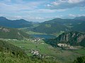
Walchsee is a municipality in the Austrian state of Tyrol in the Kufstein district. It is located in the lower Inn valley and belongs to the "Kaiserwinkl" and the "Untere Schranne".

Contents

Geography

Walchsee is located 18 km northeast of the city Kufstein, between the lake by the same name and the foot of the majestic Kaiser mountain range. Here is north Tyrol's largest preserved raised bog, the "Schwemm". The lake Walchsee covers an area of about 2.5 km² and its average summer temperature is 21°.

Borders

Walchsee borders two municipalities in the district of Kufstein (Ebbs, Rettenschöss) and three municipalities in the district of Kitzbühel (Kössen, Schwendt, Kirchdorf in Tirol). It also shares a border with the German municipality Aschau im Chiemgau, which belongs to the district of Rosenheim. The lowest point of Walchsee is located in Durchholzen (Schmiedtal 650 m) and the highest point is the Vordere Kesselschneid at 2,002 m.

Structure

Walchsee has 5 little districts: Durchholzen, Schwaigs, Oed, Winkl and Walchsee itself.

History

The first mention of Walchsee is in a document from Pope Eugene III from 1151, in which the possessions of the Rott Abbey (near Rosenheim) are recorded and the village of Walshe (Walchsee) is also mentioned. [3]

Images

Neighbouring villages

Aschau im Chiemgau (D), Ebbs, Kirchdorf in Tyrol, Kössen, Rettenschöss, Schwendt

Economy

Tourism

Resort facilities: 40 km of winter walking paths, 25 km of ski runs, 140 km of cross-country skiing tracks, sledding, skating etc.

References

  1. "Dauersiedlungsraum der Gemeinden Politischen Bezirke und Bundesländer - Gebietsstand 1.1.2018". Statistics Austria. Retrieved 10 March 2019.
  2. "Einwohnerzahl 1.1.2018 nach Gemeinden mit Status, Gebietsstand 1.1.2018". Statistics Austria. Retrieved 9 March 2019.
  3. Martin Bitschnau, Hannes Obermair (2012), Tiroler Urkundenbuch, II. Abteilung: Die Urkunden zur Geschichte des Inn-, Eisack- und Pustertals. Vol. 2: 1140–1200 (in German), Innsbruck: Universitätsverlag Wagner, p. 72, No. 464, ISBN   978-3-7030-0485-8

Commons-logo.svg Media related to Walchsee at Wikimedia Commons