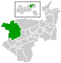
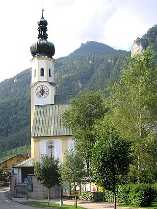
Brandenberg

Last updated
Brandenberg
Wappen at brandenberg.png
Coat of arms
Brandenberg.png
Location within Kufstein district
Austria adm location map.svg
Red pog.svg
Brandenberg
Location within Austria
Coordinates: 47°30′29″N11°53′27″E / 47.50806°N 11.89083°E / 47.50806; 11.89083 Coordinates: 47°30′29″N11°53′27″E / 47.50806°N 11.89083°E / 47.50806; 11.89083
Country Austria
State Tyrol
District Kufstein
Government
   Mayor Hans Jürgen Neuhauser
Area
[1]
  Total130.17 km2 (50.26 sq mi)
Elevation
919 m (3,015 ft)
Population
 (2018-01-01) [2]
  Total1,523
  Density12/km2 (30/sq mi)
Time zone UTC+1 (CET)
  Summer (DST) UTC+2 (CEST)
Postal code
6234
Area code 05331
Vehicle registration KU
Website www.brandenberg.
tirol.gv.at

Brandenberg is a municipality in the Austrian state of Tyrol in the district Kufstein. It consists of the Brandenberg village and the Aschau locality (German: Ortsteil).

Municipality An administrative division having corporate status and usually some powers of self-government or jurisdiction

A municipality is usually a single administrative division having corporate status and powers of self-government or jurisdiction as granted by national and regional laws to which it is subordinate. It is to be distinguished (usually) from the county, which may encompass rural territory or numerous small communities such as towns, villages and hamlets.

Austria Federal republic in Central Europe

Austria, officially the Republic of Austria, is a country in Central Europe comprising nine federated states. Its capital, largest city and one of nine states is Vienna. Austria has an area of 83,879 km2 (32,386 sq mi), a population of nearly nine million people and a nominal GDP of $477 billion. It is bordered by the Czech Republic and Germany to the north, Hungary and Slovakia to the east, Slovenia and Italy to the south, and Switzerland and Liechtenstein to the west. The terrain is landlocked and highly mountainous, lying within the Alps; only 32% of the country is below 500 m (1,640 ft), and its highest point is 3,798 m (12,461 ft). The majority of the population speaks local Bavarian dialects as their native language, and German in its standard form is the country's official language. Other regional languages are Hungarian, Burgenland Croatian, and Slovene.

Tyrol (state) State in Austria

Tyrol is a federal state (Bundesland) in western Austria. It comprises the Austrian part of the historical Princely County of Tyrol. It is a constituent part of the present-day Euroregion Tyrol–South Tyrol–Trentino. The capital of Tyrol is Innsbruck.

Brandenberg was first mentioned in 1140, and became an independent municipality in the beginning of the 19th century. The municipality is located in the valley of the Brandenberger Ache river, a tributary of the Inn River. To the north, it shares a border with Germany. Neighbouring Austrian and German municipalities are Achenkirch, Breitenbach am Inn, Kramsach, Kreuth, Rottach-Egern, Steinberg am Rofan, and Thiersee.

Brandenberger Ache river in Austria

The Brandenberger Ache is a river of Bavaria, Germany, and the Kufstein District, Austria. It is a 38 km long left tributary of the Inn. It starts as the outflow of the Spitzingsee in southern Bavaria, and flows from North to South to the town of Rattenberg where it merges with the Inn.

Germany Federal parliamentary republic in central-western Europe

Germany, officially the Federal Republic of Germany, is a country in Central and Western Europe, lying between the Baltic and North Seas to the north and the Alps, Lake Constance and the High Rhine to the south. It borders Denmark to the north, Poland and the Czech Republic to the east, Austria and Switzerland to the south, France to the southwest, and Luxembourg, Belgium and the Netherlands to the west.

Achenkirch Place in Tyrol, Austria

Achenkirch is a municipality in the Schwaz district in the Austrian state of Tyrol. It is located at the northern end of Lake Achensee.

A local specialty is the Prügeltorte cake.

Related Research Articles

Fiss Place in Tyrol, Austria

Fiss is a municipality in the Landeck district in the Austrian state of Tyrol located 10.50 km south of Landeck on the upper course of the Inn River. The main source of income is tourism.

Sankt Georgen am Reith Place in Lower Austria, Austria

Sankt Georgen am Reith is a town in the district of Amstetten in Lower Austria in Austria.
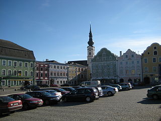
Baumkirchen Place in Tyrol, Austria

Baumkirchen is a community in the district of Innsbruck Land. It lies in the Inn Valley north of the Inn River on a batter of the Gnadenwald terrace. The village can be reached via the Inn Valley Motorway.

Flaurling Place in Tyrol, Austria

Flaurling is a municipality in the district Innsbruck country in Tyrol (Austria). It lies in the Inn valley between Innsbruck and Telfs south of the Inn River.
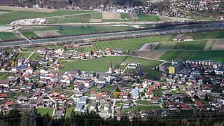
Silz, Tyrol Place in Tyrol, Austria

Silz is a municipality in the Imst district and is located 15 kilometres (9.3 mi) east of Imst and 11 kilometres (6.8 mi) west of Telfs. The ski resort Kühtai administratively belongs to the village area. Besides winter tourism also summer tourism, especially rafting on the Inn River, is an important source of income for Silz.

Burgkirchen, Austria Place in Upper Austria, Austria

Burgkirchen is a municipality in the district Braunau am Inn in the Austrian state of Upper Austria.

Franking, Austria Place in Upper Austria, Austria

Franking is a municipality in the district Braunau am Inn in the Austrian state of Upper Austria.

Gilgenberg am Weilhart Place in Upper Austria, Austria

Gilgenberg am Weilhart is a municipality in the district of Braunau am Inn in the Austrian state of Upper Austria.

Haigermoos Place in Upper Austria, Austria

Haigermoos is a municipality in the district of Braunau am Inn in the Austrian state of Upper Austria. Today nothing reminds of the infamous Weyer concentration camp for Roma placed here before 1945.

Handenberg Place in Upper Austria, Austria

Handenberg is an Austrian municipality in the district of Braunau am Inn in the Austrian state of Upper Austria.

Hochburg-Ach Place in Upper Austria, Austria

Hochburg-Ach is a municipality in the district of Braunau am Inn in the Austrian state of Upper Austria.

Höhnhart Place in Upper Austria, Austria

Höhnhart is a municipality in the district of Braunau am Inn in the Austrian state of Upper Austria.

Mining, Austria Place in Upper Austria, Austria

Mining is a municipality in the district of Braunau am Inn in the Austrian state of Upper Austria.

Moosbach, Austria Place in Upper Austria, Austria

Moosbach is a municipality in the Braunau am Inn in the Austrian state of Upper Austria.

Ostermiething Place in Upper Austria, Austria

Ostermiething is a municipality in the district of Braunau am Inn in the Austrian state of Upper Austria.

Perwang am Grabensee Place in Upper Austria, Austria

Perwang am Grabensee is a municipality in the district of Braunau am Inn in the Austrian state of Upper Austria.

Pischelsdorf am Engelbach Place in Upper Austria, Austria

Pischelsdorf am Engelbach is a municipality in the district of Braunau am Inn in the Austrian state of Upper Austria.

Sankt Georgen am Fillmannsbach Place in Upper Austria, Austria

St. Georgen am Fillmannsbach, also Sankt Georgen am Fillmannsbach is a municipality in the district of Braunau am Inn in the Austrian state of Upper Austria.

Überackern Place in Upper Austria, Austria

Überackern is a municipality in the district of Braunau am Inn in the Austrian state of Upper Austria.

Obernberg am Inn Place in Upper Austria, Austria

Obernberg am Inn is a municipality in the district of Ried im Innkreis in the Austrian state of Upper Austria.

References

  1. "Dauersiedlungsraum der Gemeinden Politischen Bezirke und Bundesländer - Gebietsstand 1.1.2018". Statistics Austria. Retrieved 10 March 2019.
  2. "Einwohnerzahl 1.1.2018 nach Gemeinden mit Status, Gebietsstand 1.1.2018". Statistics Austria. Retrieved 9 March 2019.