
Segovia is a city in the autonomous community of Castile and León, Spain. It is the capital and most populated municipality of the Province of Segovia.

Intramuros is the 0.67-square-kilometer (0.26 sq mi) historic walled area within the city of Manila, the capital of the Philippines. It is administered by the Intramuros Administration with the help of the city government of Manila.

The Puerta del Sol is a public square in Madrid, one of the best known and busiest places in the city. This is the centre of the radial network of Spanish roads. The square also contains the famous clock whose bells mark the traditional eating of the Twelve Grapes and the beginning of a new year. The New Year's celebration has been broadcast live since 31 December 1962 on major radio and television networks including Atresmedia and RTVE.

Centro is a district of Madrid, Spain. It is approximately 5.23 km2 in size. It has a population of 149,718 people and a population density of 28,587/km2. It roughly corresponds to the bulk of the housing formerly enclosed by the so-called Walls of Philip IV. The district is made up of the neighbourhoods of Cortes, Embajadores, Justicia, Universidad, Palacio and Sol.

Ciudad Colonial is the historic central neighborhood of the Dominican Republic's capital Santo Domingo. It is the oldest continuously inhabited European-established settlement in the Americas. The area has been declared a World Heritage Site by UNESCO. It is also known as Zona Colonial or more colloquially as "La Zona".

The Walls of Seville are a series of defensive walls surrounding the Old Town of Seville. The city has been surrounded by walls since the Roman period, and they were maintained and modified throughout the subsequent Visigoth, Islamic and finally Castilian periods. The walls remained intact until the 19th century, when they were partially demolished after the revolution of 1868. Some parts of the walls still exist, especially around the Alcázar of Seville and some curtain walls in the barrio de la Macarena.

The defunct Convento de Santo Tomás was a set of buildings belonging to the Dominicans, under the patronage of St. Thomas Aquinas, in Madrid.

The Convento del Carmen Calzado was a convent in the Order of Mount Carmel. It was located in the area currently occupied by the Plaza del Carmen in Madrid. This convent was founded in 1573. The Spanish confiscation during late-19th century left only the Parish church del Carmen and the ensanche (widening) of the area of Plaza del Carmen. One of the ten streets leading to the Puerta del Sol, and passing next to the facade of the parish church, is called Calle del Carmen. The site of the convent was dedicated to the Frontón Central, which would become the Cine Madrid.

The now defunct Convento de San Felipe el Real was a former Madrilenian convent of Calced Augustinian monks, located at the beginning of Calle Mayor in Madrid, next to the Puerta del Sol. Built between 16th and 17th centuries, was rise on a large pedestal, was part of it a famous talking shop of the city. One of its famous guests was Friar Luis de León. It was opposite the Palacio de Oñate.
The Walls of Felipe IV surrounded the city of Madrid between 1625 and 1868. Philip IV ordered their construction to replace the earlier Walls of Philip II and the Walls del Arrabal, which had already been surpassed by the growth of population of Madrid. These were not defensive walls, but essentially served fiscal and surveillance purposes: to control the access of goods to the city, ensure the collection of taxes, and to monitor who went in and out of Madrid. The materials used for construction were brick, mortar and compacted earth.

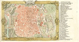
The Walls of Madrid are the five successive sets of walls that surrounded the city of Madrid from the Middle Ages until the end of the 19th century. Some of the walls had a defensive or military function, while others made it easy to tax goods entering the city. Towards the end of the 19th century the demographic explosion that came with the Industrial Revolution prompted urban expansion throughout Spain. Older walls were torn down to enable the expansion of the city under the grid plan of Carlos María de Castro.
The Christian Walls of Madrid, also known as Medieval Walls, were built in the Spanish city of Madrid between the 11th and 12th centuries, once the city passed to the Crown of Castile. They were built as an extension of the original walled enclosure of Muslim origin,to accommodate the new districts which emerged after the Reconquista.

The Walls of Philip II were walls in the city of Madrid that Philip II, in 1566, constructed for fiscal and sanitary control. The walls covered an area of about 125 hectares.]

Embajadores is an administrative neighborhood (barrio) of Madrid, belonging to the Centro District.

Old Town of Cáceres is a historic walled city in Cáceres, Spain.

The plaza de Santo Domingo is a public square in the city of Madrid, Spain.

The Arrabal of Saint Martin was a medieval arrabal (neighborhood) that sat outside the Christian Walls of Madrid. It was located around the location of the current Plaza of San Martín, and occupied the space between Calle del Arenal, the Plaza de las Descalzas, Plaza del Callao, and Calle de las Navas de Tolosa. It grew as a population center around the Monastery of Saint Martin, neighboring San Martín was the Arrabal of San Ginés, and both were absorbed by the growth of the city in the 17th century.

The history of the Puerta del Sol represents an essential part of the memory of the Villa de Madrid, not only because the Puerta del Sol is a point of frequent passage, but also because it constitutes the "center of gravity" of Madrid's urban planning. The square has been acquiring its character as a place of historical importance from its uncertain beginnings as a wide and impersonal street in the sixteenth century, to the descriptions of the first romantic travelers, the receptions of kings, popular rebellions, demonstrations, etc. It has been the scene of major events in the life of the city, from the struggle against the French invaders in 1808 to the proclamation of the Second Republic in 1931, and it has also retained its place as the protagonist of the custom of serving twelve grapes on New Year's Eve, to the sound of the chimes struck by the Correos clock. Nowadays it is a communications hub, a meeting point, a place of appointments, a place for celebrations and the beginning of demonstrations in the Capital.

Calle de Preciados, is a public pedestrian street in central Madrid, Spain, which spans from Puerta del Sol to Plaza de Santo Domingo via Plaza de Callao, where it takes a bend. It is about 500-metre long.

