Muslim Walls of Madrid

Last updated
Overview of the remains preserved on Cuesta de la Vega, near the crypt of the La Almudena Cathedral. Muralla arabe de Madrid 01.jpg
Overview of the remains preserved on Cuesta de la Vega, near the crypt of the La Almudena Cathedral.

The Muslim Walls of Madrid (also known as the Arab Walls of Madrid), of which some vestiges remain, are located in the Spanish capital city of Madrid. They are probably the oldest construction extant in the city. They were built in the 9th century, during the Muslim domination of the Iberian Peninsula, on a promontory next to Manzanares river. They were part of a fortress around which developed the urban nucleus of Madrid. They were declared an Artistic-Historic Monument in 1954. [1]

Contents

They were built in the park of Mohamed I, named in reference to Muhammad I of Córdoba, considered the founder of the city.

Along the Calle Mayor street, at number 83, next to the Viaduct that serves the Calle de Segovia, are still standing the ruins of the Tower of Narigües, which probably would have been an albarrana tower, with a separate location from the main wall itself, but connected thereto by a minor wall. Its function was to serve as a viewpoint.

In the 20th century, some remains were destroyed. Those that once existed near number 12 Calle de Bailén were lost during the construction of an apartment block, although some walls were integrated into its foundations. The remodelling of the Plaza de Oriente, completed in 1996 during the mayoral term of José María Álvarez del Manzano, led to the discovery and subsequent disappearance of numerous remains. This was not the case with the watchtower known as Tower of the Bones, whose base is on display in the underground car park of the same plaza. [1]

Between 1999 and 2000, another section was uncovered, about 70 metres (230 ft) long, under the Plaza de la Armería, formed by the main façades of the Royal Palace and Almudena Cathedral. It was excavated during the building of the Royal Collections Gallery (to open in 2023) and may correspond to the Puerta de la Sagra, one of the gates to the walled enclosure. [1]

Historical context

Walled enclosures in Al-Andalus

Detail drawing by Anton van den Wyngaerde in 1562, in which is seen the Muslim Walls of Madrid, from the disappeared Alcazar to the left, to the gate Puerta de la Vega, to the right. Muralla musulmana de Madrid dibujo.jpg
Detail drawing by Anton van den Wyngaerde in 1562, in which is seen the Muslim Walls of Madrid, from the disappeared Alcázar to the left, to the gate Puerta de la Vega, to the right.

As Torres Balbás says, "Islamization was a uniform urban mold, the result of a way of life." [2] For example, the finding of winding streets corresponds to a context in which defense is a fundamental necessity. [3]

With respect to the Walls, they fulfill several functions. Muslim cities have medinas at their cores, which include, among other buildings, the main mosque and the hammam. They are surrounded by walls, giving the area within defensive, symbolic and administrative functions. In Madrid, similarly, the walls were built to protect the city's core, not only from external danger, but also from internal revolts in the suburbs (also possibly walled). The differentiation of spaces produced by the walls, thanks to the gates - three in this case - also aided tax collection.

Thus, the city was divided between the medina or center of religious and commercial life, and the rabad, the "populous neighborhoods outside the walls". From a planning point of view, the walls promoted urbanism through both their gates and their path: the gates because through them ran the more heavily-trafficked streets and the layout because the neighborhoods would range around it. [4]

Many examples show the different possibilities when building walls, from the materials used to various designs to suit the terrain. [5]

Medieval Madrid

Drawing of the Royal Alcazar of Madrid of J. Cornelius Vermeyenen, made around 1534-1535. On the left side it can be observed that part of the Muslim Walls, in the 16th century, were in a visible state of deterioration. Alcazar 1534 1535.jpg
Drawing of the Royal Alcázar of Madrid of J. Cornelius Vermeyenen, made around 1534-1535. On the left side it can be observed that part of the Muslim Walls, in the 16th century, were in a visible state of deterioration.

The construction of these Walls is directly linked to the origin of Madrid. They were ordered to be built by the Córdoban emir Muhammad I (852 - 886) on an unspecified date between the years 860 and 880, according to a text of al-Himyari. [6] It was in an area not chosen by chance. It was a wide cultivated valley, with easy access to water reserves. [7] It defended the almudaina or Muslim citadel of Mayrit (first name of the city), located on the site currently occupied by the Royal Palace.

According to Muslim chroniclers of the time, high quality construction and materials were used to build the Walls. The historian Jerónimo de Quintana echoed these accounts in the following text of the 17th century: "very strong of masonry and mortar, raised and thick, twelve feet [almost three and half meters] in width, with large cubes, towers gatehouses and moats". [8]

The mission of the fortified complex was to monitor the path of the Manzanares, which connected the steppes of the Sierra de Guadarrama with Toledo, threatened by the incursions of the Christian kingdoms of the north peninsula. It was governed as a ribat or community, simultaneously both religious and military. [9]

The Walls of Mayrit were integrated within a complex defensive system, which extended through different parts of the Community of Madrid. [9] These included Talamanca de Jarama, Qal'-at'-Abd-Al-Salam (Alcalá de Henares) and Qal'-at-Jalifa (Villaviciosa de Odón). However, do not think of Mayrit as a core of a large entity, but as one of many entities -so is it that sometimes is difficult to find references to the city in the chronicles-. [10]

In the 10th century, the caliph of Córdoba Abd-ar-Rahman III ordered the reinforcement of the Walls, after suffering several situations of danger from the advance of the Christian King Ramiro II of León in 932. In the year 977, Almanzor chose the fortress of Mayrit as the origin point of his military campaign.

With the Christian conquest of Mayrit in the 9th century, the original walled area was expanded, raising one of wider perimeter, known as the Christian Walls of Madrid. Thus, the Madrilenian core did not lose its defensive function at any time. [11]

The image of the Virgin of Almudena, Spanish : Santa María la Real de la Almudena, lit. 'Saint Mary the Royal of la Almudena', formerly called Spanish : Santa María la Mayor, lit. 'Saint Mary the Great', was found in 1085 [12] (three centuries after the Christians hid it from Muslims) in the conquest of the city by King Alfonso VI of León and Castile, in one of the hubs of the Walls, near the gate Puerta de la Vega, and placed in the old mosque, for the worship and devotion of the Court and the people of Madrid.

Features

General information

Another view of the remains in the park of Mohamed I Muralla musulmana Madrid 2.jpg
Another view of the remains in the park of Mohamed I

The Muslim Walls of Madrid protected a fortified complex, in which there were three preeminent buildings: the alcázar, the mosque and the house of the emir or governor. [13]

The Walls started directly from the alcázar, from its southern part, with the other three sides of the building uncovered, because the rough terrain did not require a greater fortification there. To the west, the cliffs located on the plain of Manzanares river constituted a natural defense of the alcázar; a similar function was served by the ravines and gorges of the brook del Arenal, to the north and to the east.

Their total length was about 980 meters (3,220 ft), enclosing an area of about 4 hectares (9.9 acres). [14] They had an outside moat only in their eastern section, where the ground had an elevation even higher than that of the Walls.

Around the Walls there were several independent watchtowers, but we only have a historical record of the Tower of the Bones, named for its proximity to a cemetery. This was built in the 11th century, before the conquest of Madrid by the king Alfonso VI of León and Castile, and integrated into the Christian Walls as Albarrana tower.

Outside the Walls, there were different public lands dedicated to leisure and equestrian games (almusara), plus a Muslim neighborhood or medina , and a Christian suburb or mozarabs .

Gates

Detail of the gate Puerta de la Vega, in the plan of Pedro Teixeira, of 1656 Teixeira - Puerta de la Vega.jpg
Detail of the gate Puerta de la Vega, in the plan of Pedro Teixeira, of 1656

The Walls have three gates, of direct access and without any bend:

From an archaeological perspective, the Puerta de la Vega offers the most data; thus existing references use data extrapolated from the excavations. The foundations of one of the buckets that originally flanked this gate have been documented. The dimensions of the access, according to data from the excavations, would have been 4.5 and 3.5 meters (15 and 11 ft). [15] Typologically it is a narrow gate, between two towers and a poorly developed. After the archaeological activities only the foundation has been preserved, but this is outside of its original position.

Towers

The wall was organized in different towers, quadrangular, of between 3.3 and 2.4 meters wide (10.8 and 7.9 ft) according to the tower- [15] and with paw at the base, with an arrangement slightly protruding from the main wall. They were spaced approximately every 20 meters (66 ft). These stretches combined stonework of flint and limestone. [16]

Despite the measures, currently these are just highlights with respect to the wall in which they are framed. The section that must necessarily serve as a guide because of being the best preserved, that of Park Mohamed I, has about twenty m (66 ft) between each tower. There are a total of six, although one tower was lost, but is indicated by its base. The towers serve to confirm, once again, that this constitutes an enclosure of an Islamic court. The shape of the towers supports such a conclusion, as usually the Christians used a semicircular shape, clearly unlike those seen in the Park Mohamed I.

Visible fragments

Park of Mohamed I

Remains of the Muslim Walls of Madrid, in the Cuesta de la Vega, integrated within the Park of Mohamed I. Madrid muralla musulmana.jpg
Remains of the Muslim Walls of Madrid, in the Cuesta de la Vega, integrated within the Park of Mohamed I.

This is the most important fragment, both in its state of preservation and in its accessibility to visitors. The excavations carried out there in 1972-1975 and 1985 onwards have been aided by the demolition of a 19th-century building that sat on the stretch itself, revealing a lot of data. This happened two years after 1985, and also represented a restoration and enhancement of the section of the wall.

It has in view approximately 120 meters length (390 ft). This part of the Walls has been preserved by being used as a load-bearing wall in buildings of modern times, and surfaced after their demolition. However, the fact that it has been used as a foundation should not be overlooked, because all the Walls might have also had such a fate. Apparently, many sections of the Walls were rebuilt and remodeled as well, and others may have suffered worse in the course of history.

It is a stretch of a width around 2.6 meters (8 ft 6 in), which is quite consistent if put in relation to the size of the towers that are around it. There are two exterior walls that have inside masonry to mode of core. [17] The masonry is linked with lime mortar. It is of note that all materials that make the stretch could be found relatively close to the city areas, which reaffirms once again the geostrategic role of the rise in which emerged the Islamic city.

Deepening in the two facing walls, its bottoms are formed by large blocks of flint, cut only on its outer face and slightly trimmed, but not modeling, inside. From there rise ashlars of limestone, providing a new finding that the track is of al-Andalusian origin, because the materials follow the style of Cordoban rigging, which is a constant in the centuries in which life unfolds in Madrid. The Córdoban rigging is an ashlar to rope – the longest part of it abroad – and two or three blight, the short side visible. This is difficult to appreciate along the stretch, because the passage of time. In fact, it is possible that the Walls was remodeled in the 10th century after a siege of Ramiro II of León, but never possible that was rebuilt.

Finding on foot of wall the Córdoban rigging may be difficult, because when it put in value in the late 1980s was applied a render in white, if it was on track to hide some patches implanted in the wall during its time as load-bearing wall also hid some details. On the other hand, the small arch that can be seen capping could be a sort of drain without interest, which follows the documentation of modern times, which marks the passage of a small stream by that area. To try to provide a more historical perspective was recreated a small slope to try to rebuild the period atmosphere, as transformed by the growth of Madrid.

Calle Bailén 12

The calle Bailén n.º 12 is a building founded on remnants of the Walls. This was built in 1970s, [18] and though by then it already was an Artistic Historical Monument, two sections of the Walls and a tower were destroyed -one to make site to the building, and other to give way to its tenants-.

The building, however, retains some vestiges of the stretch in a very bad state, because at present are part of their private garage. These are remains very similar to those of Park of Muhamed I, because it is an extension of the same.

The incomprehensible destruction was accompanied by some documentation work, and today is known to have a width of 2.5 meters -a little narrower than the portion that has already been seen- and offered a possibility that can not usually be: the dissection of the wall. The data regarding the core of lime mortar masonry are given by this construction. [19]

Construction of Royal Collections Museum (2008), where remains of the Muslim Wall were found Museo de Colecciones Reales (Madrid) 01.jpg
Construction of Royal Collections Museum (2008), where remains of the Muslim Wall were found

Future Museum of Royal Collections

There is another large section of the Arab walls found in the late-1990s, directly opposite the Almudena Cathedral. These remains have surfaced as part of the works of the future Royal Collections Museum. As an area in which it is impossible to make any kind of archaeological tasting, the specialist Alain Kermovan traced the route through radioelectric detectors, without lifting the pavement. [1]

Are two stretches from the Islamic period, which between them account for about 70 meters. The materials used are the same, and construction techniques, but not the thickness: this exceeds, on average, the 3.2 meters, being slightly wider than previously seen. Here it has been able to verify the height, ranging around 7 meters, although this is found only in a section, because the other is destroyed completely.

Archaeological excavations

Until 1985, the archaeological excavations in the city of Madrid only had by protagonists visible elements such as fortified enclosures or churches. That, for the study of the Muslim Walls, is that since the first excavations of the late 18th century and the beginning of 19th century have been carrying out archaeological works.

In the 20th century, there are some advances over the wall. The Instituto Arqueológico de Madrid, in the sixties and seventies, performs some tasks aimed at protecting the first and second enclosure, since both had been declared "monuments" in the fifties. Thus, were carried out archaeological campaigns in some areas as the Cuesta de la Vega -between 1972 and 1975- or the Calle Mayor. [20]

The lack of visible remains playing against the excavations in finding activities related to the Muslim walled. Since 1985 it has been excavated on the Cuesta de la Vega, placing on value the most important section of this enclosure setting the park called Muhamed I, in honor of the founder of the city.

See also

Notes

  1. 1 2 3 4 Fraguas 1999.
  2. Bidagos et al. 1968, p. 79.
  3. Bidagos et al. 1968, p. 92.
  4. Montero Vallejo 2003, p. 49.
  5. Pavón 1992.
  6. Montero Vallejo 2007, p. 88.
  7. Fernández Ugalde et al. 1998, p. 26.
  8. "First Enclosure: Muslim Walls". Medieval Madrid. Archived from the original on 2009-04-19. Retrieved 2016-12-30.
  9. 1 2 Montero Vallejo 2007, p. 89.
  10. Fernández Ugalde et al. 1998, p. 30.
  11. Fernández Ugalde et al. 1998, p. 31.
  12. Casas, Narciso (2013). Historia y Arte en las Catedrales de España. Bubok. p. 423. ISBN   9788468632018.
  13. Gea Ortigas 1999.
  14. Cámara Muñoz & Gutierrez Marcos 1993, p. 173.
  15. 1 2 Fernández Ugalde et al. 1998, p. 55.
  16. Castellanos Oñate 2005.
  17. Fernández Ugalde et al. 1998, p. 52.
  18. Fernández Ugalde et al. 1998, p. 56.
  19. Fernández Ugalde et al. 1998, p. 57.
  20. Mena Muñoz & Nogueras Monteagudo 1990b, p. 256.

Related Research Articles

<span class="mw-page-title-main">Alhambra</span> Palace and fortress complex in Granada, Andalusia, Spain

The Alhambra is a palace and fortress complex located in Granada, Andalusia, Spain. It is one of the most famous monuments of Islamic architecture and one of the best-preserved palaces of the historic Islamic world, in addition to containing notable examples of Spanish Renaissance architecture.

<span class="mw-page-title-main">Madrid Atocha railway station</span> Railway station in Madrid, Spain

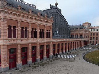
Madrid Atocha, also named Madrid Puerta de Atocha–Almudena Grandes, is the first major railway station in Madrid. It is the largest station serving commuter trains (Cercanías), regional trains from the south and southeast, intercity trains from Navarre, Cádiz and Huelva (Andalusia) and La Rioja, and the AVE high speed trains from Girona, Tarragona and Barcelona (Catalonia), Huesca and Zaragoza (Aragon), Sevilla, Córdoba, Málaga and Granada (Andalusia), Valencia, Castellón and Alicante. These train services are run by Spain's national rail company, Renfe. As of 2019, this station has daily services to Marseille, France.

<span class="mw-page-title-main">Mosque–Cathedral of Córdoba</span> Church in Andalusia, Spain

The Mosque–Cathedral of Córdoba, officially known by its ecclesiastical name of Cathedral of Our Lady of the Assumption, is the cathedral of the Roman Catholic Diocese of Córdoba dedicated to the Assumption of Mary and located in the Spanish region of Andalusia. Due to its status as a former mosque, it is also known as the Mezquita and as the Great Mosque of Córdoba.

<span class="mw-page-title-main">Alcázar of Seville</span> Royal palace in Seville, Spain

The Alcázar of Seville, officially called Royal Alcázar of Seville, is a historic royal palace in Seville, Spain. It was formerly the site of the Islamic-era citadel of the city, begun in the 10th century and then developed into a larger palace complex by the Abbadid dynasty and the Almohads. After the Castilian conquest of the city in 1248, the site was progressively rebuilt and replaced by new palaces and gardens. Among the most important of these is a richly-decorated Mudéjar-style palace built by Pedro I during the 1360s.

<span class="mw-page-title-main">History of Madrid</span>

The documented history of Madrid dates to the 9th century, even though the area has been inhabited since the Stone Age. The primitive nucleus of Madrid, a walled military outpost in the left bank of the Manzanares, dates back to the second half of the 9th century, during the rule of the Emirate of Córdoba. Conquered by Christians in 1083 or 1085, Madrid consolidated in the Late Middle Ages as a middle to upper-middle rank town of the Crown of Castile. The development of Madrid as administrative centre began when the court of the Hispanic Monarchy was settled in the town in 1561.

<span class="mw-page-title-main">Alcazaba of Málaga</span> Palatial fortification in Málaga, Spain

The Alcazaba is a palatial fortification in Málaga, Spain, built during the period of Muslim-ruled Al-Andalus. The current complex was begun in the 11th century and was modified or rebuilt multiple times up to the 14th century. It is one of the best-preserved alcazabas in Spain. The Alcazaba is also connected by a walled corridor to the higher Castle of Gibralfaro, and adjacent to the entrance of the Alcazaba are remnants of a Roman theatre dating to the 1st century AD.

<span class="mw-page-title-main">Torrelodones</span> Municipality in Community of Madrid, Spain

Torrelodones is a municipality in the northwest of the Autonomous Community of Madrid, Spain. It is situated 29 kilometers northwest from the city of Madrid. Because of its location between the Sierra de Guadarrama and the metropolitan area of the capital, it is linked to two districts in Madrid: the agricultural area of Guadarrama and the metropolitan area of Madrid.

<span class="mw-page-title-main">Barrio de La Latina (Madrid)</span>

La Latina is a historic neighborhood in the Centro district of downtown Madrid, Spain. La Latina occupies the place of the oldest area in Madrid, the Islamic citadel inside the city walls, with narrow streets and large squares. It is administratively locked almost entirely within the district of Palacio in Centro. It was named after the old hospital, founded in 1499 by Beatriz Galindo "La Latina". It occupies a large part of what is known as El Madrid de los Austrias, and although its boundaries are subjective, it could be argued that it was essentially the vicinity of the carrera de San Francisco street - that continues from the Plaza de la Cebada up to the San Francisco el Grande Basilica. These limits are: to the north, Segovia street - a deep ravine formerly occupied by the San Pedro Stream which empties into the Manzanares River, to the south there is la Ronda and Puerta de Toledo, on the east there is Toledo street - bordering Rastro and the district of Lavapiés - and to the west, Bailen street.
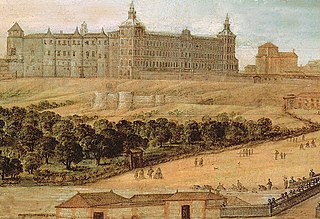
<span class="mw-page-title-main">Vicálvaro</span> District of Madrid in Spain

Vicálvaro is a district in the southeast of Madrid, Spain. It is named after the former municipality absorbed into the municipality of Madrid in 1951.

<span class="mw-page-title-main">Las Acacias (Madrid)</span> City neighborhood in Madrid, Community of Madrid, Spain

Acacias or Las Acacias is an administrative neighborhood (barrio) of Madrid belonging to the district of Arganzuela. It has an area of 1.074172 km2 (0.414740 sq mi). As of 1 February 2020, it has a population of 37,049.

<span class="mw-page-title-main">Walls of Seville</span> Defensive fortification in Seville, Spain

The Walls of Seville are a series of defensive walls surrounding the Old Town of Seville. The city has been surrounded by walls since the Roman period, and they were maintained and modified throughout the subsequent Visigoth, Islamic and finally Castilian periods. The walls remained intact until the 19th century, when they were partially demolished after the revolution of 1868. Some parts of the walls still exist, especially around the Alcázar of Seville and some curtain walls in the barrio de la Macarena.

<span class="mw-page-title-main">Walls of Philip IV</span>

The Walls of Felipe IV surrounded the city of Madrid between 1625 and 1868. Philip IV ordered their construction to replace the earlier Walls of Philip II and the Walls del Arrabal, which had already been surpassed by the growth of population of Madrid. These were not defensive walls, but essentially served fiscal and surveillance purposes: to control the access of goods to the city, ensure the collection of taxes, and to monitor who went in and out of Madrid. The materials used for construction were brick, mortar and compacted earth.

<span class="mw-page-title-main">Walls of Madrid</span> Series of walls built around the city of Madrid, Spain

The Walls of Madrid are the five successive sets of walls that surrounded the city of Madrid from the Middle Ages until the end of the 19th century. Some of the walls had a defensive or military function, while others made it easy to tax goods entering the city. Towards the end of the 19th century the demographic explosion that came with the Industrial Revolution prompted urban expansion throughout Spain. Older walls were torn down to enable the expansion of the city under the grid plan of Carlos María de Castro.

The Christian Walls of Madrid, also known as the Medieval Walls, were built in Madrid, Spain between the 11th and 12th centuries, once the city passed to the Crown of Castile. They were built as an extension of the original 9th-century Muslim Walls of Madrid to accommodate the new districts which emerged after the Reconquista.

The Walls del Arrabal were the third in a set of five walls built around Madrid, now the capital of Spain. There are no remaining ruins of the Walls del Arrabal, leaving some debate as to their extent and the period of their construction. It is possible that the walls were built as early as the 12th century, however they were most likely constructed in 1438. The walls may have been intended to protect people against the plagues that ravaged the city at the time. The walls united the urbanized suburbs of the city and prevented entry of the infected.

<span class="mw-page-title-main">Macarena Gate</span> City gate of the original walls of Seville

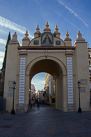
The Puerta de la Macarena, also known as Arco de la Macarena, is one of the only three city gates that remain today of the original walls of Seville, alongside the Postigo del Aceite and the Puerta de Córdoba. It is located in the calle Resolana, within the barrio de San Gil, which belongs to the district of Casco Antiguo of the city of Seville, in Andalusia, Spain. The gate faces the Basílica de La Macarena, which houses the image of the Our Lady of la Esperanza Macarena, one of the most characteristic images of the Holy Week in Seville.

<span class="mw-page-title-main">Calle Mayor (Madrid)</span> Street in Madrid, Spain

The Calle Mayor is a centric street in Madrid, Spain. Located in the Centro District, the Calle Mayor starts in the Puerta del Sol and ends at the cuesta de la Vega.

<span class="mw-page-title-main">Tower of the Bones</span>

The Tower of Bones is an Islamic watchtower, the remains of which are exhibited in the underground parking structure in the Plaza de Oriente, in the Spanish city of Madrid. It was built in the 11th century by the Muslim population that founded the Mayrit fortress two centuries earlier, as an integral part of its defensive system.

<span class="mw-page-title-main">History of the Puerta del Sol</span>

The history of the Puerta del Sol represents an essential part of the memory of the Villa de Madrid, not only because the Puerta del Sol is a point of frequent passage, but also because it constitutes the "center of gravity" of Madrid's urban planning. The square has been acquiring its character as a place of historical importance from its uncertain beginnings as a wide and impersonal street in the sixteenth century, to the descriptions of the first romantic travelers, the receptions of kings, popular rebellions, demonstrations, etc. It has been the scene of major events in the life of the city, from the struggle against the French invaders in 1808 to the proclamation of the Second Republic in 1931, and it has also retained its place as the protagonist of the custom of serving twelve grapes on New Year's Eve, to the sound of the chimes struck by the Correos clock. Nowadays it is a communications hub, a meeting point, a place of appointments, a place for celebrations and the beginning of demonstrations in the Capital.

<span class="mw-page-title-main">Walls of Cuéllar</span> Defensive walls that surround the old town of Cuéllar, Segovia, Spain

The Walls of Cuéllar are Romanesque defensive walls that surrounds the old town of the Segovian village of Cuéllar. They represent one of the most important and best preserved walled complexes in the autonomous community of Castile and León (Spain).

References

40°24′53″N3°42′57″W / 40.4148°N 3.7157°W / 40.4148; -3.7157