
The Retiro Park, also known as Buen Retiro Park or simply El Retiro, is one of the largest city parks in Madrid, Spain. The park belonged to the Spanish monarchy until 1868, when it became a public park following the Glorious Revolution.

The Puerta de Alcalá is a Neo-classical gate in the Plaza de la Independencia in Madrid, Spain.

The Paseo del Prado is one of the main boulevards in Madrid, Spain. It runs north–south between the Plaza de Cibeles and the Plaza del Emperador Carlos V, with the Plaza de Cánovas del Castillo lying approximately in the middle. The Paseo del Prado forms the southern end of the city's central axis. It enjoys the status of Bien de Interés Cultural (BIC), and as part of a combined UNESCO World Heritage Site with Buen Retiro Park.

Centro is a district of Madrid, Spain. It is approximately 5.23 km2 (2.02 sq mi) in size. It has a population of 149,718 people and a population density of 28,587 people/km2. It roughly corresponds to the bulk of the housing formerly enclosed by the so-called Walls of Philip IV. The district is made up of the neighbourhoods of Cortes, Embajadores, Justicia, Universidad, Palacio and Sol.

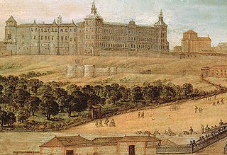
Buen Retiro Palace in Madrid was a large palace complex designed by the architect Alonso Carbonell and built on the orders of Philip IV of Spain as a secondary residence and place of recreation. It was built in what was then the eastern limits of the city of Madrid. Today, what little remains of its buildings and gardens forms the Retiro Park.
The Royal Alcázar of Madrid was a fortress located at the site of today's Royal Palace of Madrid, Madrid, Spain. The structure was originally built in the second half of the ninth century by the Muslims, then extended and enlarged over the centuries, particularly after 1560. It was at this time that the fortress was converted into a royal palace, and Madrid became the capital of the Spanish Empire. Despite being a palace, the great building kept its original Arabic title of Alcázar.

The Salón de Reinos or salón grande is a 17th-century building in Madrid, originally a wing of the Buen Retiro Palace. The Salón de Reinos and the Casón del Buen Retiro are the only survivors of the original grand scheme of the palace. Built between 1630 and 1635, the Hall of Realms housed the largest paintings in the royal collection, now all in the Museo del Prado. It is named after its paintings of the coats of arms of the 24 kingdoms which formed the Kingdom of Spain at the time of Philip IV of Spain.

The architecture of Madrid has preserved the look and feel of many of its historic neighbourhoods and streets, even though Madrid possesses a modern infrastructure. Its landmarks include the Royal Palace of Madrid, the Royal Theatre with its restored 1850 Opera House, the Buen Retiro Park, the 19th-century National Library building containing some of Spain's historical archives, a large number of national museums, and the Golden Triangle of Art located along the Paseo del Prado and comprising three art museums: Prado Museum, the Reina Sofía Museum, and the Thyssen-Bornemisza Museum, which completes the shortcomings of the other two museums. Cibeles Palace and Fountain have become the monument symbol of the city.

The M-50 orbital motorway is the outermost ring road of Madrid and its metropolitan area. It has a length of 85 km (53 mi) and, unlike the other ring roads, doesn't form a closed ring, lacking a connection in the northwest between A-6 and A-1. It runs at an average distance of 13.5 km (8.4 mi) from the Puerta del Sol. It is the longest beltway in the Madrid region, and may be compared with London's M25 motorway and Berlin's A10 beltway.

The now defunct Convento de San Felipe el Real was a former Madrilenian convent of Calced Augustinian monks, located at the beginning of Calle Mayor in Madrid, next to the Puerta del Sol. Built between 16th and 17th centuries, was rise on a large pedestal, was part of it a famous talking shop of the city. One of its famous guests was Friar Luis de León. It was opposite the Palacio de Oñate.

The Iglesia de Nuestra Señora del Buen Suceso, commonly known as Iglesia del Buen Suceso was a church of Madrid that delimited the eastern part of the Puerta del Sol (Madrid). The church comes from a remodeling of the Hospital Real de la Corte. Was doing functions of church and hospital since 1590. Its lonja was meeting place for several centuries. The church's clock would be important during this period until it was installed one of better performance on the Real Casa de Correos. Its demolition coincided with the Confiscation of Mendizábal that left space for the later expansion that was done for the Puerta del Sol.
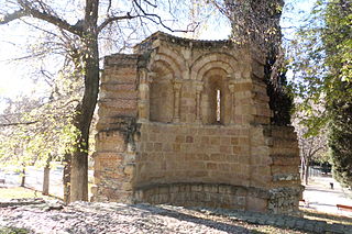
The Ermita de San Pelayo y San Isidoro is a ruined Romanesque church, originally in the city of Ávila, Spain. It was built outside the city walls, in front to the Gate of Malaventura in the south side of the Walls. In Ávila, there remains an area known as the Atrium of San Isidro. After the Spanish confiscation, it was moved to Madrid, where it had different locations. Its remains finally found accommodation in the Buen Retiro Park in central Madrid.

The Walls of Madrid are the five successive sets of walls that surrounded the city of Madrid from the Middle Ages until the end of the 19th century. Some of the walls had a defensive or military function, while others made it easy to tax goods entering the city. Towards the end of the 19th century the demographic explosion that came with the Industrial Revolution prompted urban expansion throughout Spain. Older walls were torn down to enable the expansion of the city under the grid plan of Carlos María de Castro.

The Muslim Walls of Madrid, of which some vestiges remain, are located in the Spanish capital city of Madrid. They are probably the oldest construction extant in the city. They were built in the 9th century, during the Muslim domination of the Iberian Peninsula, on a promontory next to Manzanares river. They were part of a fortress around which developed the urban nucleus of Madrid. They were declared an Artistic-Historic Monument in 1954.
The Walls del Arrabal were the third in a set of five walls built around Madrid, now the capital of Spain. There are no remaining ruins of the Walls del Arrabal, leaving some debate as to their extent and the period of their construction. It is possible that the walls were built as early as the 12th century, however they were most likely constructed in 1438. The walls may have been intended to protect people against the plagues that ravaged the city at the time. The walls united the urbanized suburbs of the city and prevented entry of the infected.

The Walls of Philip II were walls in the city of Madrid that Philip II, in 1566, constructed for fiscal and sanitary control. The walls enclosed an area of about 125 ha.

The Palacio del Marqués de Alcañices, also known as Palacio de Alcañices, was a building, now disappeared, which was located in the Calle de Alcalá of Madrid on the land that was other building that occupied Luis Méndez de Haro 6th Marquis del Carpio, a favorite of Philip IV. It belonged to the parish of San Sebastián, and occupied the number 74 of the modern numbering of the street; its other façade bordering the Paseo del Prado. Was named after its owners, the last one José Osorio y Silva, mentor of Alfonso XIII, known as Pepe Osorio and the Grand Duke of Sesto, who also held the title of Marquess of Alcañices, among others.

The Puerta de Atocha was a gate in the city walls of Madrid. It owed its name to be located in the vicinity of the old hermitage, later Convento de Nuestra Señora de Atocha. It was demolished in 1850. Its location must exit to Paseo de las Delicias

The plaza de Santo Domingo is a public square in the city of Madrid, Spain.
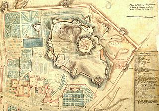
The citadel of Madrid was a star fort with three fortified enceintes constructed by the French Army during the Peninsular War, in the grounds of the Palacio del Buen Retiro, on the Retiro heights, outside the eastern gate of the city of Madrid.


