Puerta de Atocha (city gate)

Last updated

Coordinates: 40°24′24″N3°41′21″W / 40.40667°N 3.68917°W / 40.40667; -3.68917

Geographic coordinate system Coordinate system

A geographic coordinate system is a coordinate system that enables every location on Earth to be specified by a set of numbers, letters or symbols. The coordinates are often chosen such that one of the numbers represents a vertical position and two or three of the numbers represent a horizontal position; alternatively, a geographic position may be expressed in a combined three-dimensional Cartesian vector. A common choice of coordinates is latitude, longitude and elevation. To specify a location on a plane requires a map projection.

19th-century engraving of the Puerta de Atocha and the existing Fountain de la Alcachofa, both built by Ventura Rodriguez. Puerta de Atocha (Madrid).jpg
19th-century engraving of the Puerta de Atocha and the existing Fountain de la Alcachofa, both built by Ventura Rodríguez.

The Puerta de Atocha was a gate in the city walls of Madrid (Walls of Philip IV). It owed its name to be located in the vicinity of the old hermitage, later Convento de Nuestra Señora de Atocha. It was demolished in 1850. Its location must exit to Paseo de las Delicias [1]

Madrid Capital of Spain

Madrid is the capital of Spain and the largest municipality in both the Community of Madrid and Spain as a whole. The city has almost 3.3 million inhabitants and a metropolitan area population of approximately 6.5 million. It is the third-largest city in the European Union (EU), smaller than only London and Berlin, and its monocentric metropolitan area is the third-largest in the EU, smaller only than those of London and Paris. The municipality covers 604.3 km2 (233.3 sq mi).

Walls of Philip IV

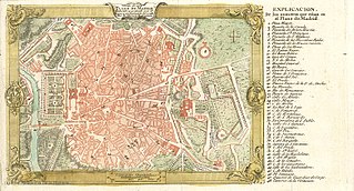
The Walls of Felipe IV surrounded the city of Madrid between 1625 and 1868. Philip IV ordered their construction to replace the earlier Walls of Philip II and the Walls del Arrabal, which had already been surpassed by the growth of population of Madrid. These were not defensive walls, but essentially served fiscal and surveillance purposes: to control the access of goods to the city, ensure the collection of taxes, and to monitor who went in and out of Madrid. The materials used for construction were brick, mortar and compacted earth.

It was added as part of the Walls of Philip IV in 1748, substituting the previous Puerta de Vallecas. [2] The last gate that was finally demolished in the mid-19th century was built by Ventura Rodríguez in 1769 on a program to improve several of the gates of Madrid, which also were built or improved the gates of Puerta de Alcalá and Puerta de Bilbao, the latter two by Sabatini. However, as described the Diccionario geográfico-estadístico de España y Portugal of López de Vargas and Miñano in 1826, the gate did not deserve "nor by its matter nor by its form, be one of the main of Madrid and was calling for the construction of a more dignified of the place [sic] in which it is located." [1]

Ventura Rodríguez Spanish architect

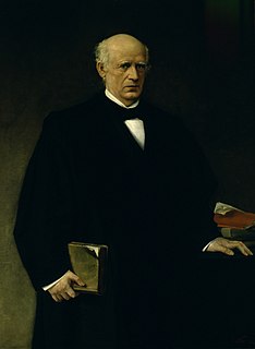
Ventura Rodríguez Tizón was a Spanish architect and artist. Born at Ciempozuelos, Rodríguez was the son of a bricklayer. In 1727, he collaborated with his father in the work at the Royal Palace of Aranjuez.

Puerta de Alcalá cultural property in Madrid Distritos: Retiro y Salamanca, Spain

The Puerta de Alcalá is a Neo-classical monument in the Plaza de la Independencia in Madrid, Spain. It is regarded as the first modern post-Roman triumphal arch built in Europe, older than the similar monuments Arc de Triomphe in Paris and Brandenburg Gate in Berlin.

Francesco Sabatini Italian architect

Francesco Sabatini, also known as Francisco Sabatini, was an Italian architect of the 18th century who worked in Spain.

The gate was demolished in 1850 to begin works on the Atocha railway station [3] in 1992, was given to the station the name of Puerta de Atocha to the new terminal of Alta Velocidad Española in honor of the missing gate.

Madrid Atocha railway station Railway station in Madrid, Spain.

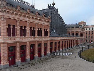
Madrid Atocha is the largest railway station in Madrid. It is the primary station serving commuter trains (Cercanías), intercity and regional trains from the south, and the AVE high speed trains from Barcelona (Catalonia), Zaragoza (Aragon), Sevilla (Andalusia), Málaga (Andalusia), Valencia and Alicante. These train services are run by the Spanish national rail company, Renfe. As of 2018, this station has daily services to Marseille in France.

AVE Spanish high speed rail network

Alta Velocidad Española (AVE) is a service of high-speed rail in Spain operated by Renfe, the Spanish national railway company, at speeds of up to 310 km/h (193 mph). Alta Velocidad Española translates to "Spanish High Speed", but the initials are also a play on the word ave, meaning "bird". As of August 2017, the Spanish AVE system is the longest HSR network in Europe with 3,240 km (2,010 mi) and the second longest in the world, after China's.

Related Research Articles

Puerta del Sol square in Madrid, Spain

The Puerta del Sol is a public square in Madrid, one of the best known and busiest places in the city. This is the centre of the radial network of Spanish roads. The square also contains the famous clock whose bells mark the traditional eating of the Twelve Grapes and the beginning of a new year. The New Year's celebration has been broadcast live on national television since 31 December 1962.

Pascual Madoz Spanish politician, statistician

Pascual Madoz Ibáñez, Spanish politician, statistician, was born at Pamplona.

Mora, Spain Place in Castile-La Mancha, Spain

Mora is a town and municipality in Toledo province, in the autonomous community of Castile-La Mancha, Spain. The area is most famous for the abandoned ruins of the San Marcos de Yegros monastery of the Order of Santiago, located northeast of the town of Mora about 10 km on the Calle de los Dolores in the village of Paraje de Yegros.

Alarcia town in Castile and León, Spain

Alarcia is a town of northern Spain, Autonomous Community of Castile and León, province of Burgos, Shire of Montes de Oca, sub-shire of Tirón-Rioja Burgalesa, in the municipality of Rábanos. It lies between the reservoir Úzquiza (west) and the peak of San Millan in the Sierra de la Demanda (southeast).

Merades

Merades is an ancient abandoned village located in the Montsià comarca, Catalonia, Spain.

Punta Carnero, Spain

Punta Carnero is a headland on the coast of Spain, near the city of Algeciras, where the eastern end of Gallows Hill descends 200 metres to meet the Mediterranean Sea. Its most prominent feature is Punta Carnero lighthouse, which marks the entrance to the Bay of Gibraltar and the Strait of Gibraltar.

Aberásturi is a village in Álava, Basque Country, Spain. It is located in the municipality of Vitoria, in the province of Álava, included in the Eastern rural area of the municipality.

Ascarza is a village in Álava, Basque Country, Spain.

Foronda village in Basque country, Spain

Foronda is a town and council belonging to the municipality of Vitoria, in the province of Álava. It is located at an altitude of 517 meters, bathed by the Zalla River.

Cala Arenas

Cala Arenas is a beach situated near the city of Algeciras in Spain, within the El Estrecho Natural Park. It is located at the southern end of the Bay of Gibraltar and faces the Strait of Gibraltar. It measures about 400 metres (1,300 ft) long by about 30 metres (98 ft) deep. The beach is somewhat difficult to access, but can be reached via coastal paths from Punta Carnero and Punta del Fraile. It consists of a series of three small coves of similar appearance, with beaches of rocks and small stones. Both the terrestrial and marine environment of the area lies within the natural park. Its surroundings are largely undisturbed by human activity; the nearest settlement is the coastal community of Getares, a small outlying development of the city of Algeciras located about 1 km to the north. The beach is framed by cliffs and the Isla de las Palomas lies a short distance offshore.

The Walls del Arrabal were the third in a set of five walls built around Madrid, now the capital of Spain. There are no remaining ruins of the Walls del Arrabal, leaving some debate as to their extent and the period of their construction. It is possible that the walls were built as early as the 12th century, however they were most likely constructed in 1438. The walls may have been intended to protect people against the plagues that ravaged the city at the time. The walls united the urbanized suburbs of the city and prevented entry of the infected.

Embajadores Ward of Madrid in Spain

Embajadores is an administrative neighborhood (barrio) of the Centro District in Madrid, Spain.

Puerta de la Macarena (Seville)

The Puerta de la Macarena, also known as Arco de la Macarena, is along with the Postigo del Aceite and the Puerta de Córdoba the only three city gates that remain today of those who had the walls of Seville. It is located in the calle Resolana, within of barrio de San Gil, which belongs to the district of Casco Antiguo of the city of Seville, in Andalusia, Spain. Facing it stands the Basílica de La Macarena, which houses the image of the Our Lady of La Esperanza Macarena, one of the most characteristic images of the Holy Week in Seville. and closely linked to the gate.

José Antonio Ramírez López (1908–1987) was a Spanish jurist and lawyer, author of a doctrinal study on the legal regime of bankruptcy.

Castle of Andrade

Castle of Andrade(in Galician, Castelo dos Andrade) is a medieval Galician fortification located in the area of Pontedeume, Province of A Coruña (Spain).

Turieno human settlement in Camaleño, San Vicente de la Barquera, Cantabria, Spain

Turieno is a town in the municipality of Camaleño.

Argüébanes human settlement in Camaleño, San Vicente de la Barquera, Cantabria, Spain

Argüébanes is a town in the municipality of Camaleño.

Mogrovejo village and neighborhood council in Cantabria, Cantabria, Spain

Mogrovejo is a small village of the municipality of Camaleño in Cantabria, Spain with 44 inhabitants in 2008.

Fermín Caballero Spanish politician, writer and journalist

Fermín Caballero y Morgáez was a Spanish geographer, journalist, writer, and liberal politician.

References

  1. 1 2 Sebastián De Miñano y Bedoya; Tomás López de Vargas Machuca (1826). "Madrid". Diccionario geográfico-estadístico de España y Portugal. 5 (first ed.). Madrid. p. 324.
  2. "Murallas, Cercas y Puertas de Madrid". www.unaventanadesdemadrid.com. Retrieved 2016-09-01.
  3. María Pilar González Yanci (1977). The rail access to Madrid. Its impact on the Urban Geography of the city. Biblioteca de Estudios Madrileños. XXI. Madrid: Instituto de Estudios Madrileños. p. 37. ISBN   840003690-5.