Erie County is a highly populated county in the U.S. state of New York. As of the 2010 census, the population was 919,040. The county seat is Buffalo. The county's name comes from Lake Erie. It was named by European colonists for the regional Iroquoian language-speaking Erie tribe of Native Americans, who lived south and east of the lake before 1654.

Silver Creek is a village in the town of Hanover in Chautauqua County, New York, United States. As of the 2010 census, the village had a population of 2,656. Silver Creek is named after a small river which runs through the village. It is on the shore of Lake Erie.
Edinboro is a borough in Erie County, Pennsylvania, United States. It is part of the Erie Metropolitan Statistical Area. As home to Edinboro University of Pennsylvania, it is a small college town, as well as a resort community. The population was 6,438 at the 2010 census, down from 6,950 at the 2000 census.

Erie is a city on the south shore of Lake Erie and the county seat of Erie County, Pennsylvania, United States. Named for the lake and the Native American Erie people who lived in the area until the mid-17th century, Erie is the fourth-largest city in Pennsylvania, as well as the largest city in Northwestern Pennsylvania, with a population of 101,786 at the 2010 census. The estimated population in 2017 had decreased to 97,369. The Erie metropolitan area, equivalent to all of Erie County, consists of 276,207 residents. The Erie-Meadville, PA Combined Statistical Area has a population of 369,331, as of the 2010 Census.

Girard Township is a township in Erie County, Pennsylvania, United States. The population was 5,102 at the 2010 census.

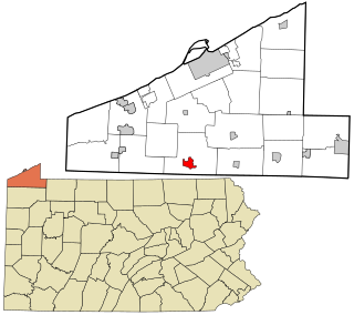
Lake City is a borough in Erie County, Pennsylvania, United States. The population was 3,031 at the 2010 census. It is part of the Erie Metropolitan Statistical Area.

McKean Township is a township in Erie County, Pennsylvania, United States. The population was 4,409 at the 2010 census, down from 4,619 at the 2000 census.

Summit Township is a township in Erie County, Pennsylvania, United States. The population was 6,603 at the 2010 census, up from 5,529 at the 2000 census.

The Ohio and Erie Canal was a canal constructed during the 1820s and early 1830s in Ohio. It connected Akron with the Cuyahoga River near its outlet on Lake Erie in Cleveland, and a few years later, with the Ohio River near Portsmouth. It also had connections to other canal systems in Pennsylvania.

The Erie National Wildlife Refuge is an 8,777-acre (3,552 ha) National Wildlife Refuge located in Crawford County, Pennsylvania. Named after the Erie tribe, it was established to provide waterfowl and other migratory birds with nesting, feeding, brooding, and resting habitat.

Conneaut Creek is a 43.5-mile (70.0 km) tributary of Lake Erie in northwestern Pennsylvania and northeastern Ohio in the United States. Via Lake Erie, the Niagara River and Lake Ontario, it is part of the watershed of the St. Lawrence River, which flows to the Atlantic Ocean.

New York State Route 426 (NY 426) is a state highway located entirely within Chautauqua County, New York, in the United States. It runs just over 13 miles (21 km) from one section of the Pennsylvania state line to another, passing through two small hamlets and providing the Southern Tier Expressway with its westernmost exit in New York. NY 426 is the westernmost north–south state highway in New York.

Elk Creek is a 30.4-mile (48.9 km) tributary of Lake Erie in Erie County, Pennsylvania in the United States. The creek is part of the Lake Erie Watershed and has a drainage basin of 99.4 square miles (257 km2). Elk Creek is stocked with brown trout and steelhead by the Pennsylvania Fish and Boat Commission.

The geography of New York state varies widely. Most of New York is dominated by farms, forests, rivers, mountains, and lakes. New York's Adirondack Park is larger than any U.S. National Park in the contiguous United States. Niagara Falls, on the Niagara River as it flows from Lake Erie to Lake Ontario, is a popular attraction. The Hudson River begins near Lake Tear of the Clouds and flows south through the eastern part of the state without draining lakes George or Champlain. Lake George empties at its north end into Lake Champlain, whose northern end extends into Canada, where it drains into the Richelieu River and then the St. Lawrence. Four of New York City's five boroughs are on the three islands at the mouth of the Hudson River: Manhattan Island, Staten Island, and Brooklyn and Queens on Long Island.

Lake Erie Basin consists of Lake Erie and surrounding watersheds, which are typically named after the river, creek, or stream that provides drainage into the lake. The watersheds are located in the states of Indiana, Michigan, New York, Ohio, and Pennsylvania in the United States, and in the Province of Ontario in Canada. The basin is part of the Great Lakes Basin and Saint Lawrence River Watershed, which feeds into the Atlantic Ocean. 80% of the lake's water flows in from the Detroit River, with only 9% coming from all of the remaining watersheds combined. A littoral zone serves as the interface between land and lake, being that portion of the basin where the lake is less than 15 feet (4.6 m) in depth.
Lake Erie Watershed is a major drainage catchment in northwestern Pennsylvania, consisting of lands with direct runoff and sub-watersheds with waterways that flow into Lake Erie and Presque Isle Bay from Crawford and Erie counties, as well as from New York. The watershed is part of the Lake Erie Basin.

The Beaver and Erie Canal, also known as the Erie Extension Canal, was part of the Pennsylvania Canal system and consisted of three sections: the Beaver Division, the Shenango Division, and the Conneaut Division. The canal ran 136 miles (219 km) north–south near the western edge of the state from the Ohio River to Lake Erie through Beaver County, Lawrence County, Mercer County, Crawford County, and Erie County, Pennsylvania.

Eighteen Mile Creek is a tributary of Lake Erie located in southern Erie County, New York, United States. The creek is the second largest tributary of Lake Erie in New York State.
LeBoeuf Creek is an 18-mile (29 km) long tributary of French Creek in Erie County, Pennsylvania in the United States. It has a drainage basin of 63.6 square miles (165 km2).