
Igloolik is an Inuit hamlet in Foxe Basin, Qikiqtaaluk Region in Nunavut, northern Canada. Because its location on Igloolik Island is close to Melville Peninsula, it is often mistakenly thought to be on the peninsula. The name "Igloolik" means "there is a house here". It derives from iglu, meaning house or building, and refers to the sod houses that were originally in the area, not to snow igloos. In Inuktitut the residents are called Iglulingmiut. The mayor of Igloolik is Joe Inooya.

The Dorset was a Paleo-Eskimo culture, lasting from 500 BC to between 1000 and 1500 AD, that followed the Pre-Dorset and preceded the Inuit in the Arctic of North America. It is named after Cape Dorset in Nunavut, Canada where the first evidence of its existence was found. The culture has been defined as having four phases due to the distinct differences in the technologies relating to hunting and tool making. Artifacts include distinctive triangular end-blades, soapstone lamps, and burins.

Southampton Island is a large island at the entrance to Hudson Bay at Foxe Basin. One of the larger members of the Canadian Arctic Archipelago, Southampton Island is part of the Kivalliq Region in Nunavut, Canada. The area of the island is stated as 41,214 km2 (15,913 sq mi) by Statistics Canada. It is the 34th largest island in the world and Canada's ninth largest island. The only settlement on Southampton Island is Coral Harbour, called in Inuktitut Salliq.

Coats Island lies at the northern end of Hudson Bay in the Kivalliq Region of Nunavut. At 5,498 km2 (2,123 sq mi) in size, it is the 107th largest island in the world, and Canada's 24th largest island.

The District of Keewatin was a territory of Canada and later an administrative district of the Northwest Territories. It was created in 1876 by the Keewatin Act, and originally it covered a large area west of Hudson Bay. In 1905, it became a part of the Northwest Territories and in 1912, its southern parts were adjoined to the provinces of Manitoba and Ontario, leaving the remainder, now called the Keewatin Region, virtually uninhabited. On April 1, 1999, the Keewatin Region was formally dissolved, as Nunavut was created from eastern parts of the Northwest Territories, including all of Keewatin.
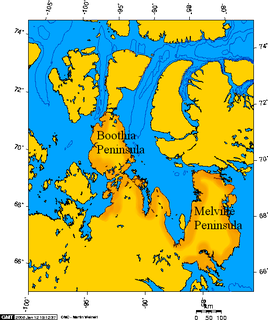
Boothia Peninsula is a large peninsula in Nunavut's northern Canadian Arctic, south of Somerset Island. The northern part, Murchison Promontory, is the northernmost point of mainland Canada.

White Island is one of the uninhabited Canadian arctic islands in Kivalliq Region, Nunavut, Canada. Located in Foxe Basin off the northern tip of Southampton Island, it measures 789 km2 (305 sq mi) in area.
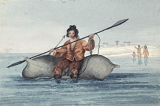
The Sadlermiut were an Inuit group living in near isolation mainly on and around Coats Island, Walrus Island, and Southampton Island in Hudson Bay. They survived into the early 20th century and were thought by some to have been the last remnants of the Dorset culture as they had preserved a culture and dialect distinct from the mainland Inuit. Despite their culture and local traditions seeming to show combined elements of both the Dorset and Thule societies, genetic studies show no Dorset admixture and prove a sole Inuit ancestry leading many to conclude the cultural difference may be entirely due to their isolation from the mainland Inuit. Research published in 2015 found that the Sadlermiut were genetically Thule who had somehow acquired Dorset cultural features, such as stone technology. It remains a mystery how they acquired Dorset technology in the absence of obvious genetic admixture such as through intermarrying.

Foxe Basin is a shallow oceanic basin north of Hudson Bay, in Nunavut, Canada, located between Baffin Island and the Melville Peninsula. For most of the year, it is blocked by sea ice and drift ice made up of multiple ice floes.

Coral Harbour, is a small Inuit community that is located on Southampton Island, Kivalliq Region, in the Canadian territory of Nunavut. Its name is derived from the fossilized coral that can be found around the waters of the community which is situated at the head of South Bay. The name of the settlement in Inuktitut is Salliq, sometimes used to refer to all of Southampton Island. The plural Salliit, means large flat island(s) in front of the mainland.
The Inuit are a group of culturally similar indigenous peoples inhabiting Inuit Nunangat, the Arctic regions of Greenland, Canada, and Alaska. The Inuit languages are part of the Eskimo–Aleut family. Inuit Sign Language is a critically endangered language isolate used in Nunavut.
The uninhabited Imiqqutailaqtuuq Islands are located in Roes Welcome Sound, closer to the mainland than Southampton Island. The island group is a part of the Qikiqtaaluk Region, in the Canadian territory of Nunavut.
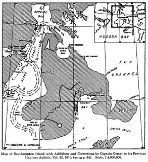
The Bell Peninsula is located on southeastern Southampton Island, in the Kivalliq Region, Nunavut, Canada. It is in close proximity to the small Inuit community of Coral Harbour. The southern shores make up the northern boundary of Hudson Bay. Foxe Basin is to the east. There are several large bays surrounding the peninsula. Bowhead whale frequent the area. The Bell Peninsula's irregular coastline is marked by five distinct points, some of which have notable archaeological sites. Mount Minto, in the north, is the highest peak. The Back Peninsula is on the eastern end of the Bell Peninsula.

The Back Peninsula is a cape located on eastern Bell Peninsula, Southampton Island, in the Kivalliq Region, Nunavut, Canada. Its southern shore is part of the northern boundary of Hudson Bay. Foxe Basin is to the north. There are two large bays, Gorden Bay and Junction Bay. Bowhead whale frequent the area. The Bell Peninsula's irregular coastline is marked by Seashore Point and Expectation Point.
Mount Minto is a mountain located on northern Bell Peninsula, Southampton Island, in Kivalliq Region, Nunavut, Canada. From eastward, it has a conical shape.
The Boas is a river on Southampton Island in Nunavut, Canada. The river rises at 64°49′58″N084°23′34″W and its mouth is located at the Bay of Gods Mercy. Proceeding inland, the river becomes braided and is about 5 kilometres (3.1 mi) wide.
Native Point is a peninsula in Kivalliq Region, Nunavut, Canada. It is located on Southampton Island's Bell Peninsula at the mouth of Native Bay. It is notable for being the location of an abandoned Sadlermiut settlement, currently an archaeological site.

Inuit Nunangat is the non-state country of the Inuit people. This Arctic homeland consists of four northern Canadian regions called Nunangit, the Canadian territory Nunavut (ᓄᓇᕗᑦ), Nunavik (ᓄᓇᕕᒃ) in northern Québec and Nunatsiavut of Labrador. Greater Nunangat could be said to encompass all Inuit lands outside of the four Canadian regions, including Kalaallit Nunaat, Inughuit Nunaat and Tunumiit Nunaat of Greenland and Iñupiaq Nunauruat of Alaska, as well as the Inuit-Métis lands of southern Labrador: NunatuKavut.


