
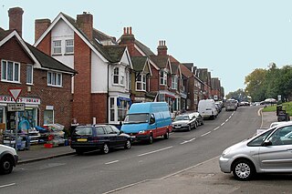
Great Sankey is a civil parish in the Borough of Warrington, Cheshire, England. It is 2 miles (3.2 km) west of Warrington town centre and had a population of 24,211 in 2001 Census.

The Metropolitan Borough of Bury is a metropolitan borough of Greater Manchester in England. It is north of Manchester, to the east of Bolton and west of Rochdale. The borough is centred around the town of Bury but also includes other towns such as Ramsbottom, Tottington, Radcliffe, Whitefield and Prestwich. Bury bounds the Lancashire districts of Rossendale and Blackburn with Darwen to the north. With a population of 194,606 in 2022, it is the smallest borough in Greater Manchester.
Horam is a village, electoral ward and civil parish in the Wealden District of East Sussex, situated three miles (4.8 km) south of Heathfield. Included in the parish are the settlements of Vines Cross and Burlow.

Tottington is a town in the Metropolitan Borough of Bury in Greater Manchester, England, on the edge of the West Pennine Moors.

Little Lever is a village in the Metropolitan Borough of Bolton, Greater Manchester, England. Within the Historic County of Lancashire, it is 2 miles (3.2 km) southeast of Bolton, 2 miles (3.2 km) west of Radcliffe and 4 miles (6.4 km) southwest of Bury. In the 19th century, the population was employed in cotton mills, paper mills, bleach works, terracotta works, a rope works and numerous collieries.

Haughton Green is a large village in Tameside, Greater Manchester, England. It formed part of the ancient township of Haughton, Lancashire, along with Haughton Dale, Higher Haughton, Lower Haughton, Haughton Hall and Haughton itself.

Adswood is a suburb of Stockport, Greater Manchester, England.
Milltown is a small settlement in County Antrim, Northern Ireland. It is within the townland of Derriaghy, about one mile to the north of Lisburn. Once a rural village, it is now part of Greater Belfast. However, it is separated from the surrounding urban area by a narrow stretch of countryside. It had a population of 1,499 people in the 2011 Census.
Lhanbryde is a village that lies 4 miles (6.4 km) east of Elgin in Moray, Scotland. Previously bisected by the A96, it was bypassed in the early 1990s and now lies to the north of this busy trunk road. It had a population of 1,880 at the 2011 Census.
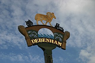
Debenham is a village and civil parish located 11 miles (18 km) north of Ipswich in the Mid Suffolk district of Suffolk, England. The River Deben rises in the parish, and flows along a prolonged ford through the village.

Bassett Green is a suburb of Southampton, which has grown from the original small village of Basset. It remains part of the electoral ward of Bassett. The area is mainly residential, with a mixture of Herbert Collins-designed houses and council built estates known as the Flowers Estate and the Leaside Way Estate. Within Bassett Green are a community centre, Bassett Green Primary School and Southampton Crematorium, as well as several of the University of Southampton's halls of residence.

Hawkshaw is a village in the Metropolitan Borough of Bury, in Greater Manchester, England. Historically a part of Lancashire, it has a population of around 1,000 people. The village has a small shop and 2 pubs called The Red Lion and The Waggon and Horses.

Upham is a small village and civil parish in the south of England located in Hampshire approximately 7 miles south-east of Winchester.

There are 236 Grade II* listed buildings in Greater Manchester, England. In the United Kingdom, the term listed building refers to a building or other structure officially designated as being of special architectural, historical or cultural significance; Grade II* structures are those considered to be "particularly significant buildings of more than local interest". In England, the authority for listing under the Planning Act 1990 rests with English Heritage, a non-departmental public body sponsored by the Department for Culture, Media and Sport.

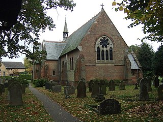
Christ Church is an active church in Walshaw, Greater Manchester, England, and is a Grade II* listed building. Designed in the Gothic Revival style by Lawrence Booth in 1888, the building was funded by Rev John Gorrell Haworth and Miss Nancy Haworth, and took four years to complete. It was erected as a memorial to Manchester cotton and fustian manufacturer Jesse Haworth, as noted prominently across the west facade of the building.
Christchurch is a village in the Fenland district of Cambridgeshire, England. The population of the civil parish at the 2011 Census was 833. The village is sited close to the Cambridgeshire/Norfolk border.

New Islington is an inner city area of Manchester, in North West England. Historically in Lancashire and part of Ancoats, it has taken a separate identity to reflect its changed status as a regeneration area.

Collace is a parish in Perthshire, Scotland, 8 miles northeast of Perth, in the Carse of Gowrie district. The parish boundary includes the neighbouring villages of Kinrossie and Saucher.
Tottington is a town in the Metropolitan Borough of Bury, Greater Manchester, England, and the area also includes the villages of Walshaw and Greenmount and the surrounding countryside. The area is unparished, and contains 33 listed buildings that are recorded in the National Heritage List for England. Of these, two are listed at Grade II*, the middle grade, and the others are at Grade II, the lowest grade. The area is partly agricultural and partly residential, and its listed buildings include farmhouses and farm buildings, private houses and associated structures, an ancient cross, churches and associated structures, a village lock-up, and schools.

