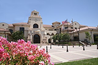
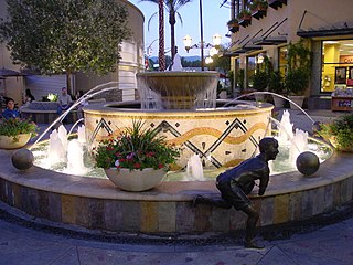
Temecula is a city in southwestern Riverside County, California, United States. The city had a population of 110,003 as of the 2020 census and was incorporated on December 1, 1989. The city is a tourist and resort destination, with the Temecula Valley Wine Country, Old Town Temecula, the Temecula Valley Balloon & Wine Festival, the Temecula Valley International Film Festival, championship golf courses, and resort accommodations contributing to the city's economic profile.

Santa Rosa Island is the second largest of the Channel Islands of California at 53,195 acres. Santa Rosa is located about 26 miles (42 km) off the coast of Santa Barbara, California in Santa Barbara County and is part of Channel Islands National Park.

The Santa Rosa Plateau is an upland plateau and southeastern extension of the Santa Ana Mountains in Riverside County, southern California. It is bounded by the rapidly urbanizing Inland Empire cities of Murrieta and Temecula to the northeast and southeast, respectively.
Santa Clarita is a city in northwestern Los Angeles County in the U.S. state of California. With a 2020 census population of 228,673, it is the third-most populous city in Los Angeles County, the 17th-most populous in California, and the 103rd-most populous city in the United States. It is located about 30 miles (48 km) northwest of downtown Los Angeles, and occupies 70.75 square miles (183.2 km2) of land in the Santa Clarita Valley, along the Santa Clara River. It is a classic example of a U.S. edge city, satellite city, or boomburb.
Vail Lake is a large reservoir in western Riverside County, southern California.

Rancho San Francisco was a land grant in present-day northwestern Los Angeles County and eastern Ventura County, California. It was a grant of 48,612 acres (19,673 ha) by Governor Juan B. Alvarado to Antonio del Valle, a Mexican army officer, in recognition for his service to Alta California. It is not related to the city of San Francisco.

Henry Mayo Newhall was an American businessman whose extensive land holdings became the Southern California communities of Newhall, Saugus and Valencia, and the city of Santa Clarita.

The Newhall Land and Farming Company is a land management company based in Valencia, Santa Clarita, California, United States. The company is responsible for the master community planning of Valencia and previously developed other areas such as Canyon Country and Newhall which together with Saugus and Valencia would merge to create the city of Santa Clarita in 1987. The company is also responsible for the management of farm land elsewhere in the state.
Warner's Ranch, near Warner Springs, California, was notable as a way station for large numbers of emigrants on the Southern Emigrant Trail from 1849 to 1861, as it was a stop on both the Gila River Trail and the Butterfield Overland Mail stagecoach line (1859-1861). It was also operated as a pioneering cattle ranch.
Temecula Creek, formerly known as the Temecula River, runs 32.6 miles (52.5 km) through southern Riverside County, California, United States, past the rural communities of Radec and Aguanga, and ending 0.5 miles (0.80 km) southeast of the original city center of Temecula. The creek is filled with boulders and is typically dry and sandy. It is a relatively undeveloped coastal-draining watershed. Until the 1920s, water flowed in Temecula Creek year-round.
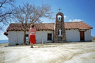
Warner Springs is set of springs and a small unincorporated community in northern San Diego County, California. Warner Springs is on the Pacific Crest Trail.
Rancho Santa Rosa was a 47,815-acre (193.50 km2) Mexican land grant in present day Riverside County, California given in 1846 by Governor Pio Pico to Juan Moreno. At the time of the US patent, Rancho Santa Rosa was a part of San Diego County. Riverside County was created by the California Legislature in 1893 by taking land from both San Bernardino and San Diego Counties. The site is now registered as a California Historical Landmark.
Rancho Little Temecula was a 2,233-acre (9.04 km2) Mexican land grant in present-day Riverside County, California given in 1845 by Governor Pío Pico to Pablo Apis. The grant was one of the few held by indigenous people. The grant is south of present-day Temecula and is bordered on the north by Temecula Creek. At the time of the US patent, Rancho Little Temecula was a part of San Diego County. Riverside County was created by the California Legislature in 1893 by taking land from both San Bernardino and San Diego Counties.
Rancho Temecula was a 26,609-acre (107.68 km2) Mexican land grant in present-day Riverside County, California given on December 14, 1844 by Governor Manuel Micheltorena to Feliz Valdez. The grant extended south along the east bank Murrieta Creek to Temecula Creek and encompassed present-day Temecula, Murrieta and Murrieta Hot Springs. At the time of the US patent, Rancho Temecula was a part of San Diego County. Riverside County was created by the California Legislature in 1893 by taking land from both San Bernardino and San Diego Counties.
Rancho Pauba was a 26,598-acre (107.64 km2) Mexican land grant in present-day Riverside County, California given in 1844 by Governor Manuel Micheltorena to Vicente Moraga and Luis Arenas. The grant was just east of present-day Temecula. At the time of the US patent, Rancho Pauba was a part of San Diego County. Riverside County was created by the California Legislature in 1893 by taking land from both San Bernardino and San Diego Counties.
Rancho Suey was a 48,834-acre (197.62 km2) Mexican land grant in present-day southern San Luis Obispo County and northern Santa Barbara County, California given in 1837 by Governor Juan B. Alvarado to María Ramona Carrillo de Pacheco. The grant was east of present-day Santa Maria and extended along the San Luis Obispo-Santa Barbara County line, and between the Santa Maria River and the Cuyama River.

Riverside County is a county located in the southern portion of the U.S. state of California. As of the 2020 census, the population was 2,418,185, making it the fourth-most populous county in California and the 10th-most populous in the United States. The name was derived from the city of Riverside, which is the county seat.

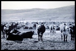
Empire Ranch is a working cattle ranch in southeastern Pima County, Arizona, that was placed on the National Register of Historic Places in 1976. In its heyday, Empire Ranch was one of the largest in Arizona, with a range spanning over 180 square miles (470 km2), and its owner, Walter L. Vail, was an important figure in the establishment of southern Arizona's cattle industry. It is currently owned by the Bureau of Land Management with a grazing lease to a private operator.
Willow Springs Station was a changing station at Alamos or Willow Springs along the Second Division route of the Butterfield Overland Mail, in what is now Murrieta, in Riverside County, California. It was also known as Alamos, Clines's or Kline's, or Willows, was one of the later Butterfield Overland Mail stations, placed in 1859, between some of the original stations for changing teams and providing water between stops in hot dry areas. Willow Springs, also originally known as Alamos Springs, was located west of the hills that line the east side of the Temecula Valley, on land of the Rancho Temecula, near Santa Gertrudis Creek on the low flood plain of Murrieta Creek, between Santa Gertrudis and Warm Springs Creek.
Butterfield Valley is a valley along the course of Temecula Creek, in Riverside County, California. Its lower end is now filled by Vail Lake. It heads at 33°27′39″N116°55′34″W and its mouth is at the site of the Vail Lake Dam at the head of the deep canyon Temecula Creek has cut through Oak Mountain to the Pauba Valley.

