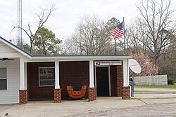
Waresboro | |
---|---|
Coordinates: 31°14′56.4″N82°28′27.84″W / 31.249000°N 82.4744000°W | |
Country | United States |
State | Georgia |
County | Ware |
Population (2020) | |
• Total | 375 |
Time zone | UTC-5 (Eastern (EST)) |
• Summer (DST) | UTC-4 (EDT) |
ZIP code | 31503 [1] |
Area code | 912 |
Waresboro is an unincorporated community and census-designated place (CDP) in Ware County, Georgia, United States, located west of Waycross. The community is part of the Waycross micropolitan statistical area.
The 2020 census listed a population of 375. [2]
In 1824, Waresboro was the first county seat of Ware County. In 1860, newspaperman and lawyer Carey Wentworth Styles practiced law in Waresboro, after moving to the community from Brunswick where he had been mayor. While in Waresboro, Styles published the Georgia Forester, a weekly newspaper. In 1861, Styles was elected as a delegate from Ware County to the Georgia Secession Convention where, along with the other delegate from Ware, Col. William Angus McDonald, Styles voted to secede. [3] Styles left Waresboro at the beginning of the Civil War, when he enlisted in the Confederate Army. After the war, he moved to Atlanta, where he founded The Atlanta Constitution . [4]
A railroad junction located some miles away from Waresboro grew into the city of Waycross, which eventually became the hub of commerce in Ware County. In 1873, Waycross replaced Waresboro as the county seat, sending the Waresboro area into a slow decline.
The community of Waresboro was granted a city charter by act of the Georgia General Assembly on December 9, 1893. [5] As the neighboring city of Waycross grew, the fortunes of Waresboro diminished. Eventually, the city reverted to an unincorporated community, which remains the current status.
According to the Waycross Journal Herald dated November 13, 1975, Louise Mock donated the oldest home in Ware County to the Okeefenokee Heritage Center. The house originally stood at the intersection of Church Street and Old Stagecoach Road, before being moved, in 1982, to the Heritage Center, where it underwent partial restoration. It was the home of General Thomas Hilliard, and is preserved as The Hillard House at the Heritage Center. [6] It is now on display, and contains furniture, implements, and tools of the period of original occupation.
Census | Pop. | Note | %± |
---|---|---|---|
2020 | 375 | — | |
U.S. Decennial Census [7] 2020 [8] |
Waresboro was first listed as a census designated place in the 2020 U.S. Census. [8]
Race / Ethnicity (NH = Non-Hispanic) | Pop 2020 [8] | % 2020 |
---|---|---|
White alone (NH) | 327 | 87.20% |
Black or African American alone (NH) | 20 | 5.33% |
Native American or Alaska Native alone (NH) | 1 | 0.27% |
Asian alone (NH) | 0 | 0.00% |
Pacific Islander alone (NH) | 0 | 0.00% |
Some Other Race alone (NH) | 1 | 0.27% |
Mixed Race or Multi-Racial (NH) | 7 | 1.87% |
Hispanic or Latino (any race) | 19 | 5.07% |
Total | 375 | 100.00% |
In 2020, it had a population of 375.
DeKalb County is located in the north central portion of the U.S. state of Georgia. As of the 2020 census, the population was 764,382, making it Georgia's fourth-most populous county. Its county seat is Decatur.
Mableton is a city in Cobb County, Georgia, United States. Voters of the unincorporated area of Mableton approved a referendum to incorporate on November 8, 2022, and six council members were elected on March 21, 2023, with Michael Owens elected as mayor of Mableton in the 2023 Mableton mayoral election. According to the 2020 census, the census-designated area Mableton had a population of 37,115; the city has more. Upon Brookhaven's cityhood in December 2012, Mableton was previously the largest unincorporated CDP in Metro Atlanta. With boundaries described in Appendix A of House Bill 839, Mableton is the largest city in Cobb County in terms of population and includes historical Mableton, along with the Six Flags area, areas of unincorporated Smyrna, and parts of unincorporated South Cobb.
Vinings is an unincorporated community and census-designated place (CDP) in Cobb County, Georgia, United States that runs along the Chattahoochee River bank across from Buckhead. As of the 2020 census, the CDP had a total population of 12,581. Located next to the affluent Paces section of Buckhead in northwest Atlanta, Vinings is known for its historic sites, shopping districts, proximity to local freeways and The Battery, and nearby nature areas. The United States Postal Service assigns "Atlanta" to the ZIP Code (30339) that includes Vinings.
Belvedere Park is an unincorporated community and census-designated place (CDP) in DeKalb County, Georgia, United States. The population was 15,113 at the 2020 census.
Candler-McAfee is an unincorporated community and census-designated place (CDP) in DeKalb County, Georgia, United States. It is located east of Atlanta approximately 10 miles (16 km) east of Downtown Atlanta and to the south of Decatur, Georgia The population was 23,025 at the 2010 census.
Druid Hills is a community which includes both a census-designated place (CDP) in unincorporated DeKalb County, Georgia, United States, as well as a neighborhood of the city of Atlanta. The CDP's population was 14,568 at the 2010 census. The CDP formerly contained the main campus of Emory University and the Centers for Disease Control and Prevention (CDC); however, they were annexed by Atlanta in 2018. The Atlanta-city section of Druid Hills is one of Atlanta's most affluent neighborhoods with a mean household income in excess of $238,500.
Gresham Park is an unincorporated community and census-designated place (CDP) in DeKalb County, Georgia, United States. The population was 7,700 at the 2020 census.
North Druid Hills, also known as Briarcliff or Toco Hills, is an unincorporated community and census-designated place in DeKalb County, Georgia, United States. The population was 18,947 at the 2010 census. The commercial center of the area is the Toco Hill Shopping Center, located near the intersection of North Druid Hills Road and LaVista Road.
Lithia Springs is an unincorporated community and census-designated place, formerly incorporated as a city, located in northeastern Douglas County, Georgia, United States. As of the 2020 census, the community had a population of 16,644. The area is named for its historic lithia mineral water springs.
Sandy Springs is a city in northern Fulton County, Georgia, United States, and a suburb of Atlanta. The city's population was 108,080 at the 2020 census, making it Georgia's 7th most populous city. It is the site of several corporate headquarters, including UPS, Newell Brands, Inspire Brands, Focus Brands, Cox Enterprises, and Mercedes-Benz USA's corporate offices.
Deenwood is an unincorporated community and census-designated place (CDP) in Ware County, Georgia, United States. The population was 2,207 at the 2020 census. It is part of the Waycross micropolitan statistical area. Deenwood Baptist Church is named after this geographical area.
Sunnyside is an unincorporated community and census-designated place (CDP) in Ware County, Georgia, United States. The population was 1,472 in 2020. It is part of the Waycross micropolitan statistical area.
Manor is an unincorporated community and census-designated place (CDP) in Ware County, Georgia, United States. It lies southwest of Waycross on U.S. Route 84. The community is part of the Waycross Micropolitan Statistical Area.
Charles City is a census-designated place (CDP) in Charles City County, Virginia, United States. It is the county seat of Charles City County. The population as of the 2020 census was 104.
Statenville is an unincorporated community and the county seat of Echols County, Georgia, United States. It was formerly a census-designated place (CDP) with a population of 1,040 at the 2010 census. The ZIP code is 31648, and the area code 229.
Dixie Union is an unincorporated community and census-designated place (CDP) in Ware County, Georgia, United States. It lies north of Waycross on U.S. Route 1 and 23. The community is part of the Waycross Micropolitan Statistical Area.
Millwood is an unincorporated community and census-designated place (CDP) in Ware County, Georgia, United States, located west of Waycross. The community is part of the Waycross Micropolitan Statistical Area.
The Waycross Micropolitan Statistical Area (μSA), as defined by the United States Census Bureau, is an area consisting of two counties in Georgia, anchored by the city of Waycross.
Mineral Bluff is a census-designated place and unincorporated community located in Fannin County in the U.S. state of Georgia. Its population was 223 as of the 2020 census. The community is situated 6 miles (10 km) northeast of the city of Blue Ridge, the county seat, 80 miles (130 km) east of Chattanooga, Tennessee, and 100 miles (160 km) north of Atlanta.
Cogdell is an unincorporated community and census-designated place (CDP) in the northeast corner of Clinch County, Georgia, United States. It is on Georgia State Route 122, 22 miles (35 km) west of Waycross and 24 miles (39 km) east of Lakeland. Homerville, the Clinch county seat, is 10 miles (16 km) to the south.