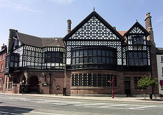
Altrincham is a market town in Trafford, Greater Manchester, England, south of the River Mersey. It is 8 miles (13 km) southwest of Manchester, 3 miles (5 km) southwest of Sale and 10 miles (16 km) east of Warrington. At the 2011 census, it had a population of 52,419.

Manchester Oxford Road railway station is a railway station in Manchester, England, at the junction of Whitworth Street West and Oxford Street. It opened in 1849 and was rebuilt in 1960. It is the third busiest of the four stations in Manchester city centre.
The Manchester, Sheffield and Lincolnshire Railway (MS&LR) was formed in 1847 when the Sheffield, Ashton-under-Lyne and Manchester Railway joined with authorised but unbuilt railway companies, forming a proposed network from Manchester to Grimsby. It pursued a policy of expanding its area of influence, especially in reaching west to Liverpool, which it ultimately did through the medium of the Cheshire Lines Committee network in joint partnership with the Great Northern Railway (GNR) and the Midland Railway.

Timperley is a suburban village in the borough of Trafford, in Greater Manchester, England. Within the boundaries of the historic county of Cheshire, it is approximately six miles southwest of central Manchester. The population at the 2021 census was 11,323.

The Cheshire Lines Committee (CLC) was formed in the 1860s and became the second-largest joint railway in Great Britain. The committee, which was often styled the Cheshire Lines Railway, operated 143 miles (230 km) of track in the then counties of Lancashire and Cheshire. The railway did not become part of the Big Four during the implementation of the 1923 grouping, surviving independently with its own management until the railways were nationalised at the beginning of 1948. The railway served Liverpool, Manchester, Stockport, Warrington, Widnes, Northwich, Winsford, Knutsford, Chester and Southport with connections to many other railways.

Altrincham Interchange is a transport hub in Altrincham, Greater Manchester, England. It consists of a bus station on Stamford New Road, a Northern Trains-operated heavy rail station on the Mid-Cheshire Line, and a light rail stop which forms the terminus of Manchester Metrolink's Altrincham line. The original heavy rail element of the station was opened by the Manchester, South Junction and Altrincham Railway as Altrincham and Bowdon railway station in April 1881, changing to Altrincham railway station in May 1974. The Metrolink element opened in June 1992. The Interchange underwent a complete redevelopment, at a cost of £19 million, starting in mid-July 2013. The new bus station opened officially on 7 December 2014.

The Mid-Cheshire line is a railway line in the north-west of England that runs from Chester to Edgeley Junction, Stockport; it connects Chester with Manchester Piccadilly, via Knutsford. After Chester Northgate closed in 1969, the section between Mickle Trafford Junction and Chester was used for freight trains only until it closed in 1992; from Mickle Trafford, passenger trains use the Chester–Warrington line to Chester General instead. The route taken by passenger trains has changed over the years and now differs considerably from the original. Between 2001 and 2014, passenger journeys on the line increased to over 1.7 million per year. A near doubling of the passenger service was expected to occur from December 2018, however this did not materialise.

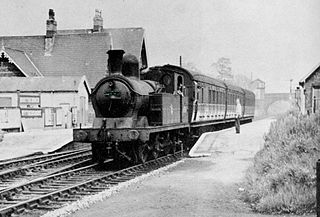
The Manchester South Junction and Altrincham Railway (MSJ&AR) was a suburban railway which operated an 8+1⁄2-mile (14 km) route between Altrincham in Cheshire and Manchester London Road railway station in Manchester.

Brooklands is a tram stop and park and ride site on the Altrincham Line of Greater Manchester's light-rail Metrolink system in the Brooklands area of Sale. It opened on 15 June 1992 as part of Phase 1 of Metrolink's expansion.

The Stockport, Timperley and Altrincham Junction Railway (ST&AJR) was authorised by an act of Parliament, passed on 22 July 1861 to build a 8 miles 17 chains (13.2 km) railway from Stockport Portwood to Altrincham.
Northenden railway station in Sharston, Manchester, England, was built by the Stockport, Timperley and Altrincham Junction Railway (ST&AJ) and opened for passenger and goods traffic on 1 February 1866.

Skelton Junction is a complex of railway junctions south of Manchester in Timperley, near Altrincham. The Cheshire Lines Committee's Liverpool to Manchester line, via the Glazebrook East Junction to Skelton Junction Line and the LNWR's Warrington and Altrincham Junction Railway, fed into the junction from Liverpool in the west. The Manchester, South Junction, and Altrincham Railway provided a connection from the Altrincham direction and a short spur from Timperley towards Stockport, while the CLC's Stockport, Timperley, and Altrincham Junction Railway continued east to Stockport.
West Timperley railway station was situated on the Glazebrook East Junction–Skelton Junction line of the Cheshire Lines Committee between Glazebrook and Stockport Tiviot Dale. It served the locality between 1873 and 1964.

Broadheath (Altrincham) railway station served Broadheath and the northern part of Altrincham in Cheshire, England, between its opening in 1853 and closure in 1962.
Cheadle LNW railway station was a railway station that served Cheadle, Cheshire, England, between 1866 and its closure in 1917.

Dunham Massey railway station was a stop on the Warrington and Altrincham Junction Railway. It served the village of Dunham Massey, in Cheshire, England. The station opened in 1854 and closed in 1962.

Heatley & Warburton railway station was located in Heatley near Warburton, Greater Manchester. It opened in 1853 and closed in 1962.
Dunham W&SR railway station served Dunham Town between 1854 and closure in 1855.

The Glazebrook East Junction–Skelton Junction line was a railway line from Glazebrook to Skelton Junction in Greater Manchester. It connected the Cheshire Lines Committee main line from Liverpool Central to Manchester Central with lines in the Stockport area, allowing freight traffic to bypass central Manchester. It also carried a local passenger service between Stockport and Warrington Central until the early 1960s.

The Altrincham Line is a tram line of the Manchester Metrolink running from Manchester to Altrincham in Greater Manchester. Originally a railway line, it was, along with the Bury Line, converted into a tramway during 1991–92, as part of the first phase of the Metrolink system.


