Altrincham Line

Last updated

Altrincham Line
Metrolink Tram Approaching Trafford Bar, David Dixon, 3371036.jpg
M5000 fleet #3026 approaching Trafford Bar on a service to Bury via Market Street.
Overview
Locale Manchester
Altrincham
Termini
Stations11
Service
Type Tram/Light rail
System Manchester Metrolink
Rolling stock Bombardier M5000 (2009-Present)
AnsaldoBreda T-68/T68A (1992-2014)
History
Opened15 June 1992
Technical
Line length7.6 miles (12.2 km)
CharacterConverted railway line
Track gauge 4 ft 8+12 in (1,435 mm) standard gauge
Electrification 750 volts DC overhead
Operating speed50 mph (80km/h)
Route map

Contents

BSicon uCONTg.svg
BSicon uSTR.svg
BSicon uINT.svg
0:21
Deansgate-Castlefield
( National Rail logo.svg Deansgate)
BSicon umbKRZo +cerulean.svg
BSicon uBHF.svg
0:19
Cornbrook
BSicon udCONTgq.svg
BSicon uABZgr.svg
to Pomona
 
BSicon dCONTgq.svg
BSicon umKRZu.svg
BSicon dCONTfq.svg
BSicon uHST.svg
0:16
Trafford Bar
BSicon uABZgl.svg
BSicon udCONTfq.svg
to Firswood
 
BSicon uHST.svg
0:14
Old Trafford
BSicon uHST.svg
0:12
Stretford
BSicon uhbKRZWae.svg
BSicon uSKRZ-Bo.svg
BSicon uHST.svg
0:09
Dane Road
BSicon uHST.svg
0:07
Sale BSicon BICYCLE.svg
BSicon uHST.svg
0:06
Brooklands
BSicon uHST.svg
0:04
Timperley
BSicon uINT.svg
0:02
Navigation Road National Rail logo.svg
BSicon uKINTe.svg
0:00
Altrincham National Rail logo.svg BSicon BUS.svg BSicon BICYCLE.svg

The Altrincham Line is a tram line of the Manchester Metrolink running from Manchester to Altrincham in Greater Manchester. Originally a railway line, it was, along with the Bury Line, converted into a tramway during 1991–92, as part of the first phase of the Metrolink system.

Route

Route map. Altrincham Line Map.png
Route map.

The line runs south-west from Manchester city centre, rising from a ramp which takes the tracks onto the streets of central Manchester, just east of Deansgate-Castlefield stop, and then runs along a former railway viaduct, parallel to the heavy rail Manchester to Warrington and Liverpool line as far as Cornbrook; just west of which the Eccles Line diverges to the north-west, and the Altrincham line runs south-west under the railway through an underpass. Cornbook stop was opened in 1999 as an interchange stop between the Altrincham and Eccles lines. The line then runs south-west along the former MSJ&AR line, and connects the towns of Stretford and Sale before running to Altrincham. The line uses old railway lines converted to light-rail operation, and has no street-running sections. [1]

On the stretch between Timperley, and the terminus at Altrincham, the alignment is shared with the Network Rail Mid-Cheshire Line: There are two tracks; the tram line uses one track, and the railway uses the other, both operating as bi-directional single track lines. Both Navigation Road station, and Altrincham Interchange are shared tram/train interchange stations. [1] [2]

History

The Altrincham line prior to Metrolink, being operated by a Class 304 unit near Sale in 1989. Suburban Sale - geograph.org.uk - 829470.jpg
The Altrincham line prior to Metrolink, being operated by a Class 304 unit near Sale in 1989.
Map of the original MSJAR. MSJAR map.jpg
Map of the original MSJAR.

The line was originally a railway: The Manchester South Junction and Altrincham Railway (MSJ&AR) which was opened in 1849, and ran between Altrincham and London Road Station (now Piccadilly) in Manchester. With some trains running into Manchester Central via a connection at Cornbrook. [3]

In response to competition from trams, which were taking away business from the railway, the line was electrified between London Road and Altrincham in 1931 using the 1,500 volt DC overhead system. [3]

In 1958, services were cut back to terminate at Manchester Oxford Road, as the line between Oxford Road and the recently renamed Piccadilly station had been re-electrified at 25 kV AC. By the late 1960s the original 1,500 V DC system had become non-standard, and both the overhead line equipment and the electric rolling stock had reached the end of their working lives, it was clear they would need replacement: In 1971 British Rail converted the line to operate at the now-standard 25 kV AC system, and replaced the 40-year old rolling stock with newer Class 304 EMUs, which operated the line for the next 20 years until the line was converted to Metrolink operation in 1991. [3]

The Altrincham line was identified by transport planners in the 1980s, as one of the local railway lines in the Greater Manchester area, which could be split off from the main line network and converted to light-rail operation. It was chosen for conversion as part of the first phase of the Metrolink, along with the Manchester Victoria to Bury Line to the north of Manchester: The two previously unconnected lines were to be linked together by a new street-running line across Manchester city-centre, which included a branch to Manchester Piccadilly railway station. [4]

Heavy rail services ended on the Altrincham line on 24 December 1991, in order for the conversion to light rail to begin. [3] The conversion process involved converting the overhead electrification to work at the tramway standard of 750 volts DC, and refurbishing the stations to improve access for the disabled etc. Several stations were renamed: the former Old Trafford became Trafford Bar, while Warwick Road became Old Trafford. [2]

Also, a number of works were carried out in order to separate the line from the heavy rail network:

A T-68 tram at Altrincham station in 1992, shortly after the line was opened to trams. Altrincham station - geograph.org.uk - 764479.jpg
A T-68 tram at Altrincham station in 1992, shortly after the line was opened to trams.

Phase one of the Metrolink opened in stages during 1992; from Bury to Victoria on 6 April 1992; the street running section from Victoria to G-Mex (now Deansgate–Castlefield) on 27 April; Deansgate–Castlefield to Altrincham on 15 June; then the branch to Piccadilly Railway station on 20 July. [6]

Services

Service patterns have varied over the years, however as of February 2017, during Monday to Saturday daytimes a tram operates every six minutes between Altrincham and Manchester, alternating between terminating at Etihad Campus (via Piccadilly) or Bury. During the evenings, and on Sundays and bank holidays the frequency drops to 12 minutes and only run to Etihad Campus. [7]

Rolling stock

All services are operated by M5000 trams. Between 1992 and 2009, the line was operated by the original fleet of 26 T-68 trams. From 2009 the new fleet of M5000 trams was introduced, and these replaced the original T-68 trams. which were withdrawn from service during 2012–14. [8]

Related Research Articles

<span class="mw-page-title-main">Manchester Piccadilly station</span> Railway station in Manchester, England

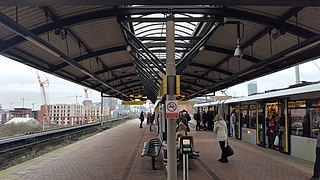
Manchester Piccadilly is the main railway station of the city of Manchester, in the metropolitan county of Greater Manchester, England. Opened originally as Store Street in 1842, it was renamed Manchester London Road in 1847 and became Manchester Piccadilly in 1960. Located to the south-east of the city centre, it hosts long-distance intercity and cross-country services to national destinations including London, Birmingham, Nottingham, Glasgow, Edinburgh, Cardiff, Bristol, Exeter, Plymouth, Reading, Southampton and Bournemouth; regional services to destinations in Northern England including Liverpool, Leeds, Sheffield, Newcastle and York; and local commuter services around Greater Manchester. It is one of 19 major stations managed by Network Rail. The station has 14 platforms: 12 terminal and two through platforms. Piccadilly is also a major interchange with the Metrolink light rail system with two tram platforms in its undercroft.

<span class="mw-page-title-main">Manchester Metrolink</span> Tram system in Greater Manchester, England

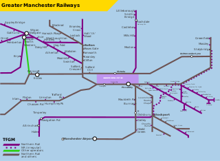
Manchester Metrolink is a tram/light rail system in Greater Manchester, England. The network has 99 stops along 64 miles (103 km) of standard-gauge route, making it the most extensive light rail system in the United Kingdom. Over the 2022/23 financial year 36 million passenger journeys were made on the system.

<span class="mw-page-title-main">Manchester Victoria station</span> Railway station in Manchester, England

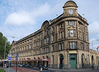
Manchester Victoria station in Manchester, England, is a combined mainline railway station and Metrolink tram stop. Situated to the north of the city centre on Hunts Bank, close to Manchester Cathedral, it adjoins Manchester Arena which was constructed on part of the former station site in the 1990s. Opened in 1844 and part of the Manchester station group, Manchester Victoria is Manchester's second busiest railway station after Piccadilly, and is the busiest station managed by Northern.

<span class="mw-page-title-main">Castlefield</span> Human settlement in England

Castlefield is an inner-city conservation area in Manchester, North West England. The conservation area which bears its name is bounded by the River Irwell, Quay Street, Deansgate and Chester Road. It was the site of the Roman era fort of Mamucium or Mancunium which gave its name to Manchester. It was the terminus of the Bridgewater Canal, the world's first industrial canal, built in 1764; the oldest canal warehouse opened in 1779. The world's first passenger railway terminated here in 1830, at Liverpool Road railway station and the first railway warehouse opened here in 1831.

<span class="mw-page-title-main">Manchester Central railway station</span> Former railway station in England

Manchester Central railway station was a railway station in Manchester city centre, England. One of Manchester's main railway terminals between 1880 and 1969, the building was converted into an exhibition and conference centre which was opened in 1986, originally known as G-MEX, but now named Manchester Central. The structure is a Grade II* listed building.

<span class="mw-page-title-main">Altrincham Interchange</span> Railway, bus and tram interchange in Greater Manchester, England

Altrincham Interchange is a transport hub in Altrincham, Greater Manchester, England. It consists of a bus station on Stamford New Road, a Northern Trains-operated heavy rail station on the Mid-Cheshire Line, and a light rail stop which forms the terminus of Manchester Metrolink's Altrincham line. The original heavy rail element of the station was opened by the Manchester, South Junction and Altrincham Railway as Altrincham and Bowdon railway station in April 1881, changing to Altrincham railway station in May 1974. The Metrolink element opened in June 1992. The Interchange underwent a complete redevelopment, at a cost of £19 million, starting in mid-July 2013. The new bus station opened officially on 7 December 2014.

<span class="mw-page-title-main">Navigation Road station</span> Railway station in Greater Manchester, England

Navigation Road is a station that serves both Northern Trains and Manchester Metrolink located in the east of Altrincham, in Greater Manchester, England. It consists of a Northern Trains-operated heavy rail station on the Mid-Cheshire Line, and an adjoining light rail stop on the Altrincham Line of Greater Manchester's Metrolink network. The original heavy rail element of the station was opened by the Manchester, South Junction and Altrincham Railway in 1931, and the Metrolink element opened in 1992. A level crossing operates at the southern end of the station.

<span class="mw-page-title-main">Mid-Cheshire line</span>

The Mid-Cheshire line is a railway line in the north-west of England that runs from Chester to Edgeley Junction, Stockport; it connects Chester with Manchester Piccadilly, via Knutsford. After Chester Northgate closed in 1969, the section between Mickle Trafford Junction and Chester was used for freight trains only until it closed in 1992; from Mickle Trafford, passenger trains use the Chester–Warrington line to Chester General instead. The route taken by passenger trains has changed over the years and now differs considerably from the original. Between 2001 and 2014, passenger journeys on the line increased to over 1.7 million per year. A near doubling of the passenger service was expected to occur from December 2018, however this did not materialise.

<span class="mw-page-title-main">Manchester, South Junction and Altrincham Railway</span> Suburban railway in Manchester

The Manchester South Junction and Altrincham Railway (MSJ&AR) was a suburban railway which operated an 8+12-mile (14 km) route between Altrincham in Cheshire and Manchester London Road railway station in Manchester.

<span class="mw-page-title-main">Cornbrook tram stop</span> Manchester Metrolink tram stop

Cornbrook tram stop is a tram stop on Greater Manchester's light rail Metrolink system in the Cornbrook area of Manchester, England. It is an interchange station, allowing passenger transfer between the network's Altrincham, Eccles, Airport, Trafford Park and South Manchester lines. The station opened on 6 December 1999 for line transfers and allowed street-level entry and exit to the public from 3 September 2005. It takes its name from Cornbrook Road, between the A56 and Pomona Docks on the Manchester Ship Canal, and was built on what was a Cheshire Lines Committee route to Manchester Central railway station. The stop is one of the most used on the Metrolink network.

<span class="mw-page-title-main">Deansgate-Castlefield tram stop</span> Manchester Metrolink tram stop

Deansgate-Castlefield is a tram stop on Greater Manchester's Metrolink light rail system, on Deansgate in the Castlefield area of Manchester city centre. It opened on 27 April 1992 as G-Mex tram stop, taking its name from the adjacent G-Mex Centre, a concert, conference and exhibition venue; the G-Mex Centre was rebranded as Manchester Central in 2007, prompting the Metrolink stop to be renamed on 20 September 2010. The station underwent redevelopment in 2014–15 to add an extra platform in preparation for the completion of the Second City Crossing in 2016–17.

<span class="mw-page-title-main">History of Manchester Metrolink</span>

The history of Manchester Metrolink begins with its conception as Greater Manchester's light rail system in 1982 by the Greater Manchester Passenger Transport Executive, and spans its inauguration in 1992 and the successive phases of expansion.

<span class="mw-page-title-main">Manchester station group</span> Four stations in Manchester, England

The Manchester station group is a station group of four railway stations in Manchester city centre, England; this consists of Manchester Piccadilly, Manchester Oxford Road, Manchester Victoria and Deansgate. The station group is printed on national railway tickets as MANCHESTER STNS. For passengers travelling from one of the 91 National Rail stations in Greater Manchester, the four stations are printed as MANCHESTER CTLZ which additionally permits the use of Metrolink tram services in Zone 1.

<span class="mw-page-title-main">Bury Line</span> Manchester Metrolink line

The Bury Line is a tram line of the Manchester Metrolink running from Manchester city centre to Bury in Greater Manchester. Originally a railway line, it was, along with the Altrincham Line, converted into a tram line during 1991–92, as part of the first phase of the Metrolink system.

<span class="mw-page-title-main">Eccles Line</span> Manchester Metrolink line

The Eccles Line is a tram line of the Manchester Metrolink in Greater Manchester running from Manchester to Eccles via Salford Quays, with a short spur to MediaCityUK. It was opened in phases during 1999–2000 as part of the second phase of the system's development. The spur to MediaCityUK was opened in 2010. The line contains a mixture of reserved track beds and a street running section.

<span class="mw-page-title-main">Airport Line (Manchester Metrolink)</span> Manchester Metrolink line

The Airport Line is a tram line of the Manchester Metrolink in Manchester, England, running from Manchester city centre to Manchester Airport via Wythenshawe. It opened in November 2014 as part of phase three of the system's expansion.

<span class="mw-page-title-main">Proposed developments of Manchester Metrolink</span> Development of Manchester Metrolink light rail system

This is a list of confirmed or proposed future developments of the Manchester Metrolink light rail system in Greater Manchester, England.

<span class="mw-page-title-main">Zone 1 (Manchester Metrolink)</span>

Zone 1 of the Manchester Metrolink light rail network is the heart of the system where all of the other lines converge. Its boundaries are broadly equivalent to those of Manchester city centre, and approximately mirror the city's Inner Ring Road. Within Zone 1, first opened in 1992 as the City Zone, trams largely run along semi-pedestrianised streets rather than on their own separate alignment. The original route between the Altrincham and Bury lines ran to Victoria station via Market Street and High Street, and was soon joined by a branch to Piccadilly station by a three-way delta junction. A second route between the South-West and North-Eastern parts of the network was built to ease congestion on the original line. Opened in 2017, the Second City Crossing (2CC) added one additional stop to the network.

References

  1. 1 2 "Metrolink : Routes : Altrincham". thetrams.co.uk. Retrieved 8 January 2016.
  2. 1 2 3 "Manchester to Altrincham". Light Rail Transit Association. Retrieved 8 January 2016.
  3. 1 2 3 4 "A Brief Rail History of Manchester". Light Rail Transit Association. Archived from the original on 7 March 2016. Retrieved 8 January 2016.
  4. "Metrolink History 1". Light Rail Transit Association. Archived from the original on 22 June 2017. Retrieved 9 January 2016.
  5. 1 2 "Manchester, City South". Light Rail Transit Association. Retrieved 9 January 2016.
  6. "An Introduction to Metrolink". Light Rail Transit Association. Archived from the original on 28 October 2016. Retrieved 9 January 2016.
  7. "Metrolink – Tram Times – Altrincham". Metrolink / Transport for Greater Manchester. Retrieved 9 January 2016.
  8. "T68 and T68a — Metrolink phase 1 and 2". Light Rail Transit Association. Archived from the original on 7 March 2016. Retrieved 9 January 2016.
Template:Attached KML/Altrincham Line
KML is from Wikidata