
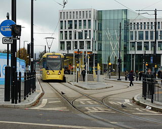
Manchester Airport station is a railway, tram, bus and coach station at Manchester Airport, England which opened at the same time as the second air terminal in 1993. The station is 9+3⁄4 miles (15.7 km) south of Manchester Piccadilly, at the end of a short branch from the Styal Line via a triangular junction between Heald Green and Styal stations. Manchester Metrolink tram services were extended to the airport in 2014 and operate to Manchester Victoria.

Hucknall station, also formerly known as Hucknall Byron station, is a railway station and tram stop in Hucknall, Nottinghamshire, England. It is located on the Robin Hood railway line 5 miles (8 km) north of Nottingham and is also the northern terminus of the Nottingham Express Transit (NET) tram system. The station has park and ride facilities, with nearly 450 parking spaces for use by both tram and train passengers.

Rochdale railway station is a multi-modal transport hub in Rochdale, Greater Manchester, England. It consists of a Northern-operated heavy rail station on the Caldervale Line, and an adjoining light rail stop on Metrolink's Oldham and Rochdale Line. The original heavy-rail element of the station was opened by the Manchester and Leeds Railway in 1839 0.5 miles (0.80 km) to the south of Rochdale town centre. The Metrolink element opened in February 2013. Further changes to the station are planned as part of the Northern Hub rail-enhancement scheme.
Rochdale Town Centre is a tram stop and the terminus on the Oldham and Rochdale Line (ORL) of Greater Manchester's light-rail Metrolink system. It was constructed as part of Phase 3b of the system's expansion, and is located on Smith Street, adjacent to Rochdale Interchange and Number One Riverside, in central Rochdale, England. It opened on 31 March 2014.
Drake Street tram stop was a proposed tram stop for Greater Manchester's Metrolink light rail system, that was to be created to serve passengers boarding and alighting at Drake Street in Rochdale, England. It was also known by the name Wet Rake tram stop, and was set to be located on the Oldham and Rochdale Line between Rochdale railway station and Rochdale Town Centre tram stop.

South Chadderton is a tram stop on the Oldham and Rochdale Line (ORL) of Greater Manchester's light-rail Metrolink system. It opened to passengers on 13 June 2012 and is located between Drury Lane and Stanley Road in the Coalshaw Green area of southern Chadderton, a part of the Metropolitan Borough of Oldham, England. It was purpose-built for Metrolink as part of Phase 3a of the system's expansion, on the route of the former Oldham Loop Line.

Monsall is a tram stop on the Oldham and Rochdale Line (ORL) of Greater Manchester's light-rail Metrolink system in the Monsall area of Manchester in North West England. It was built as part of Phase 3a of the system's expansion, on the route of the former Oldham Loop Line, and opened to passengers on 13 June 2012.

Velopark is a tram stop on the East Manchester Line (EML) of Greater Manchester's light-rail Metrolink system. It opened on 11 February 2013, after a three-day free trial for local residents. The stop was constructed as part of Phase 3a of the Metrolink's expansion, and is located beside Manchester Velodrome, in Clayton, Manchester, England. During planning and construction phases, the stop was known as New East and as Sportcity-Velodrome.

Ashton Moss is a tram stop on the East Manchester Line, built as part of Phase 3b of the Manchester Metrolink. The station opened on 9 October 2013, ahead of the originally-publicised schedule of the winter of 2013–14. The stop has an island platform, and is located on Lord Sheldon Way near the Ashton Moss leisure complex and Snipe Retail Park on Ashton New Road. The station is served by a 200 space Park + Ride car park, with electric vehicle parking facilities.

Ashton West is a tram stop on the East Manchester Line (EML) of Greater Manchester's light-rail Metrolink system. It was built as part of Phase 3b of the Metrolink's expansion, and is located on Lord Sheldon Way near the Ashton Moss leisure complex, in western Ashton-under-Lyne, Tameside, England. The stop opened on 9 October 2013, ahead of the originally-publicised schedule of the winter of 2013–14. The stop primarily serves the aforementioned leisure and retail complex, and is also the closest to the Tameside Stadium, home of Curzon Ashton F.C.

Firswood is a tram stop on the South Manchester Line (SML) and Airport Line of Greater Manchester's light-rail Metrolink system. Located in the Firswood area of Stretford, it was built as part of Phase 3a of the network's expansion, and opened on 7 July 2011.

St Werburgh's Road is a tram stop on the South Manchester Line (SML) and Airport Line of Greater Manchester's light-rail Metrolink system in Chorlton-cum-Hardy, Manchester. It was built as part of Phase 3a of the network's expansion and opened on 7 July 2011.
Didsbury Village is a tram stop on the South Manchester Line on the light-rail Metrolink network in Greater Manchester, England. It serves the South Manchester suburb of Didsbury.
Woodhouse Park tram stop was a proposed Metrolink tram stop on the phase 3b plans to Manchester Airport. It was due to open in 2016 but was dropped from plans. The tram stop would have served the Woodhouse Park area of Wythenshawe in Greater Manchester.
Haveley tram stop was a proposed tram stop on the phase 3b plans to Manchester Airport which would have been located immediately east of the M56 motorway. It was originally due to open in 2016 but was dropped from the plans.

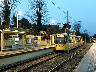
Sale Water Park is a tram stop for Phase 3b of the Manchester Metrolink. It opened on 3 November 2014. and is on the Airport Line on Rifle Road near the Sale Water Park.
Hardy Farm tram stop was a proposed future tram stop on the phase 3b plans to Manchester Airport, which would have been on the north side of Sale Water Park. It was due to open in 2016 but was dropped from the plans.

Syngrou Fix station is an interchange between Athens Metro Line 2 and the Athens Tram. The metro station opened on 16 November 2000 as part of the Dafni extension, and the tram stop opened on 19 July 2004 as part of the initial scheme.
This timeline of Manchester Metrolink lists significant events in the history of Greater Manchester's light rail network.

