Exchange Square tram stop

Last updated

Exchange Square is a tram stop on the Manchester Metrolink's Second City Crossing line, and opened on 6 December 2015 as part of Phase 2CC of the network's expansion. [1] [2] It is located by the main entrance to the Manchester Arndale shopping centre, and is also close to the Printworks.

Contents

Exchange Square
Metrolink station
New Metrolink Stop at Exchange Square, David Dixon, 4762757.jpg
Exchange Square tram stop on the day of opening.
General information
Location Exchange Square, Manchester
England
Coordinates 53°29′04″N2°14′33″W / 53.4844°N 2.2426°W / 53.4844; -2.2426
Grid reference SJ839986
Line(s) Second City Crossing
Platforms2 (island)
Other information
StatusIn operation
Fare zone1
History
Opened6 December 2015;8 years ago (2015-12-06)
Location
Exchange Square tram stop

History

The 2CC (Second City Crossing) route was first proposed in 2011 as a means to improve capacity and relieve congestion as the rest of the system expanded. [3] [4] [5] [6] Funded by the Greater Manchester Transport Fund, its route begins at a rebuilt St Peter's Square tram stop, and runs along Princess Street, Cross Street and Corporation Street to re-join the original Metrolink line at Victoria. [5] [7] Exchange Square is the line's only tram stop.

The Second City Crossing was granted approval on 8 October 2013 by the Secretary of State for Transport, [6] [8] and signed off on 28 October 2013 by the GMCA. [9]

Construction began in 2014 and the line from Victoria to Exchange Square was tested in November 2015. [10] The stop opened as a north-facing terminus on 6 December 2015 with trams running to Shaw and Crompton at first. The full Second City Crossing was completed in early 2017 from Exchange Square to St Peter's Square. [11] [12] [13] Services to East Didsbury and Rochdale then joined the 2CC. [14]

Layout

Exchange Square tram stop consists of two platforms (island platform). There are four large canopies over the stop which covers most of the platforms. At the stop, there are eight seats and four perch seats on each platform. There are two ticket machines back-to-back near the centre of the stop. One passenger help point is also located near the ticket machines.

Two dot matrix passenger information displays hang from the canopies serving one platform each, and show estimated arrival times for trams in minutes up to 30 minutes prior (up to three at a time) and number of carriages.

There are two ramps at each end of the platforms, providing step-free access for passengers, and several signs on the platforms indicating the name of the stop, its fare zone, tram destinations, and some indicate any closure notices or announcements for passengers.

Services

Services run every 12 minutes on all routes. Some routes (not shown here) only run during peak times.

From this stop, services run to East Didsbury in one direction and to Victoria, Oldham and Rochdale in the other. Tram stops at Shudehill and Market Street are both a 3-5 minute walk away from here, forming out-of-station interchanges.

Preceding station Manchester metrolink logo.PNG Manchester Metrolink Following station
St Peter's Square
towards East Didsbury
East Didsbury–Shaw (peak only) Victoria
East Didsbury–Rochdale Victoria

Transport connections

Other trams

Exchange Square tram stop is a three minute walk away from Shudehill Interchange: a tram stop and bus station. Tram services operate from Shudehill to Manchester Airport and Bury, and Altrincham during peak times.

The same services operate through Market Street, a five minute walk away.

Manchester Victoria rail station is around the same distance away, and also has a tram stop.

Buses

Bus services operate close by near the National Football Museum, on routes 41, 59, 113, and 135. To the south, also nearby, is the 2 Free Bus route, and 8, X41, and X43.

Trains

This tram stop is not connected to any railway stations, but the nearest one is Manchester Victoria, a 3-5 minute walk away. Manchester Victoria can also be reached directly via tram.

Related Research Articles

<span class="mw-page-title-main">Manchester Metrolink</span> Tram system in Greater Manchester, England

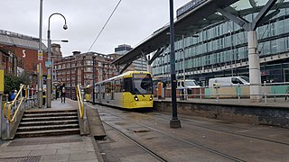
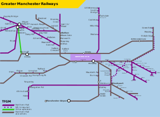
Manchester Metrolink is a tram/light rail system in Greater Manchester, England. The network has 99 stops along 64 miles (103 km) of standard-gauge route, making it the most extensive light rail system in the United Kingdom. Over the 2022/23 financial year 36 million passenger journeys were made on the system.

<span class="mw-page-title-main">Manchester city centre</span> Central business district in England

Manchester City Centre is the central business district of Manchester, England, within the confines of Great Ancoats Street, A6042 Trinity Way, and A57(M) Mancunian Way, which collectively form an inner ring road. The City Centre ward had a population of 17,861 at the 2011 census.

<span class="mw-page-title-main">Transport for Greater Manchester</span> Public transport organisation in Greater Manchester in North West England

Transport for Greater Manchester (TfGM) is a local government body responsible for co-ordinating transport services throughout Greater Manchester in North West England. It is an executive arm of the Greater Manchester Combined Authority (GMCA), the city region's administrative authority. The strategies and policies of Transport for Greater Manchester are set by the GMCA and its Greater Manchester Transport Committee (GMTC). The committee is made up of 33 councillors appointed from the ten Greater Manchester boroughs, as well as the Mayor of Greater Manchester.

<span class="mw-page-title-main">St Peter's Square tram stop</span> Manchester Metrolink tram stop

St Peter's Square is a tram stop in St Peter's Square in Manchester city centre, England. It opened on 27 April 1992 and is in Zone 1 of Greater Manchester's Metrolink light rail system.

<span class="mw-page-title-main">Deansgate-Castlefield tram stop</span> Manchester Metrolink tram stop

Deansgate-Castlefield is a tram stop on Greater Manchester's Metrolink light rail system, on Deansgate in the Castlefield area of Manchester city centre. It opened on 27 April 1992 as G-Mex tram stop, taking its name from the adjacent G-Mex Centre, a concert, conference and exhibition venue; the G-Mex Centre was rebranded as Manchester Central in 2007, prompting the Metrolink stop to be renamed on 20 September 2010. The station underwent redevelopment in 2014–15 to add an extra platform in preparation for the completion of the Second City Crossing in 2016–17.

<span class="mw-page-title-main">Piccadilly Gardens tram stop</span> Manchester Metrolink tram stop

Piccadilly Gardens is a tram stop in Zone 1 of Greater Manchester's Metrolink light rail system. It is located beside Piccadilly Gardens in Manchester city centre, and serves both as a transport hub, and interchange station.

<span class="mw-page-title-main">Shudehill Interchange</span> Manchester Metrolink tram stop

Shudehill Interchange is a transport hub between Manchester Victoria station and the Northern Quarter in Manchester city centre, England, which comprises a Metrolink stop and a bus station.

<span class="mw-page-title-main">Transport in Manchester</span> Overview of the transport infrastructure of Greater Manchester

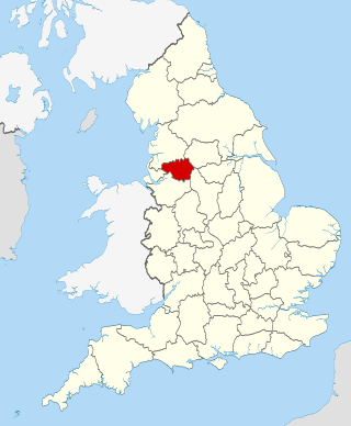
The transport infrastructure of Greater Manchester is built up of numerous transport modes and forms an integral part of the structure of Greater Manchester and North West England – the most populated region outside of South East England which had approximately 301 million annual passenger journeys using either buses, planes, trains or trams in 2014. Its position as a national city of commerce, education and cultural importance means the city has one of the largest and most thorough transport infrastructures which is heavily relied upon by its 2.8 million inhabitants in the Greater Manchester conurbation and further afield in the North West region. Public transport comes under the jurisdiction of Transport for Greater Manchester.

<span class="mw-page-title-main">St Werburgh's Road tram stop</span> Manchester Metrolink tram stop

St Werburgh's Road is a tram stop on the South Manchester Line (SML) and Airport Line of Greater Manchester's light-rail Metrolink system in Chorlton-cum-Hardy, Manchester. It was built as part of Phase 3a of the network's expansion and opened on 7 July 2011.

<span class="mw-page-title-main">West Didsbury tram stop</span> Manchester Metrolink tram stop

West Didsbury is a tram stop on the South Manchester Line (SML) of Greater Manchester's light-rail Metrolink system. It opened to passengers on 23 May 2013, in West Didsbury, South Manchester, England.

<span class="mw-page-title-main">History of Manchester Metrolink</span>

The history of Manchester Metrolink begins with its conception as Greater Manchester's light rail system in 1982 by the Greater Manchester Passenger Transport Executive, and spans its inauguration in 1992 and the successive phases of expansion.

<span class="mw-page-title-main">Imperial War Museum tram stop</span> Manchester Metrolink tram stop

Imperial War Museum is a tram stop on the Manchester Metrolink's Trafford Park Line. It is located adjacent to Trafford Wharf Road and serves Imperial War Museum North. It opened on 22 March 2020.

<span class="mw-page-title-main">The Trafford Centre tram stop</span> Manchester Metrolink tram stop

The Trafford Centre is a tram stop on the Manchester Metrolink's Trafford Park Line, and the line's current terminus. It is located adjacent to Barton Dock Road between Ellesmere Circle and Bright Circle, and serves the like-named shopping centre.

<span class="mw-page-title-main">Manchester station group</span> Four stations in Manchester, England

The Manchester station group is a station group of four railway stations in Manchester city centre, England; this consists of Manchester Piccadilly, Manchester Oxford Road, Manchester Victoria and Deansgate. The station group is printed on national railway tickets as MANCHESTER STNS. For passengers travelling from one of the 91 National Rail stations in Greater Manchester, the four stations are printed as MANCHESTER CTLZ which additionally permits the use of Metrolink tram services in Zone 1.

This timeline lists significant events in the history of Greater Manchester's light rail network called the Manchester Metrolink.

<span class="mw-page-title-main">East Manchester Line</span> Manchester Metrolink line

The East Manchester Line (EML) is a tram line of the Manchester Metrolink in Greater Manchester, England, running from Manchester to Ashton-under-Lyne via Droylsden and Audenshaw. The line opened in 2013 as part of phase three of the system's expansion.

<span class="mw-page-title-main">South Manchester Line</span> Manchester Metrolink line

The South Manchester Line (SML) is a tram line of the Manchester Metrolink in Manchester, England, running from Manchester city centre to Didsbury. The line opened as far as St. Werburgh's Road in 2011 and then to East Didsbury in 2013 as part of phase three of the system's expansion, along a former railway trackbed.

<span class="mw-page-title-main">Airport Line (Manchester Metrolink)</span> Manchester Metrolink line

The Airport Line is a tram line of the Manchester Metrolink in Manchester, England, running from Manchester city centre to Manchester Airport via Wythenshawe. It opened in November 2014 as part of phase three of the system's expansion.

<span class="mw-page-title-main">Proposed developments of Manchester Metrolink</span> Development of Manchester Metrolink light rail system

This is a list of confirmed or proposed future developments of the Manchester Metrolink light rail system in Greater Manchester, England.

<span class="mw-page-title-main">Zone 1 (Manchester Metrolink)</span>

Zone 1 of the Manchester Metrolink light rail network is the heart of the system where all of the other lines converge. Its boundaries approximately mirror the city's Inner Ring Road. Within Zone 1, first opened in 1992 as the City Zone, trams largely run along semi-pedestrianised streets rather than on their own separate alignment.

References

  1. Second city crossing route
  2. Second city crossing Archived 16 March 2012 at the Wayback Machine Greater Manchester Transport – 2011
  3. "Metrolink second city crossing 'vital' for Manchester". BBC News. 8 June 2011. Retrieved 7 January 2013.
  4. "Salford Infrastructure Delivery Plan" (PDF). Salford City Council. February 2012. Archived from the original (PDF) on 20 May 2013. Retrieved 22 January 2013.
  5. 1 2 TfGM; GMCA (2011). Greater Manchester's third Local Transport Plan 2011/12 – 2015/16 (PDF). Transport for Greater Manchester. p. 84. Archived from the original (PDF) on 3 March 2016. Retrieved 16 February 2013.
  6. 1 2 "Ministers clear way for second city centre Metrolink line". Place North West. 7 October 2013. Retrieved 7 October 2013.
  7. Qureshi, Yakub (23 January 2013). "New city line is 'vital for future of Metrolink'". Manchester Evening News. Retrieved 23 January 2013.
  8. "Manchester city centre tram route's green light by Government". BBC News . 8 October 2013. Retrieved 8 October 2013.
  9. Williams, Jennifer (28 October 2013). "Second cross-city tram link gets green light". Manchester Evening News. Retrieved 28 October 2013.
  10. Charlotte Dobson (1 November 2015). "Pictured: First trams tested on Manchester's Second City Crossing line as Metrolink aim to have Exchange Square open for Christmas". men.
  11. Jennifer Williams (28 October 2013). "Second cross-city Metrolink tram link gets green light". Manchester Evening News. Retrieved 2 February 2014.
  12. "Metrolink Capital Update" (PDF). TfGM. 2 October 2015.
  13. "Metrolink Second City Crossing set to open". British Trams Online. Retrieved 2 December 2015.
  14. "Exchange Square". TfGM. Retrieved 28 January 2018.