
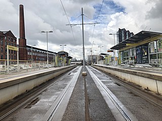
Manchester Metrolink is a tram/light rail system in Greater Manchester, England. The network has 99 stops along 64 miles (103 km) of standard-gauge route, making it the most extensive light rail system in the United Kingdom. Over the 2022/23 financial year 36 million passenger journeys were made on the system.

Droylsden is a town in Tameside, Greater Manchester, England, 4.1 miles (6.6 km) east of Manchester city centre and 2.2 miles (3.5 km) west of Ashton-under-Lyne, with a population at the 2011 Census of 22,689.

Chorlton is a stop on the South Manchester Line (SML) and Airport Line of the Metrolink light-rail system in Chorlton-cum-Hardy, Manchester, England. It was built as part of Phase 3a of the network's expansion, and opened on 7 July 2011 on a section of the former Cheshire Lines Committee railway.

Stretford is a tram stop on the Altrincham Line of Greater Manchester's light-rail Metrolink system. It is located in Stretford, on the corner of Chester Road and Edge Lane. It opened on 15 June 1992 as part of Phase 1 of Metrolink's expansion.

Trafford Bar is a tram stop on Greater Manchester's light rail system, Metrolink, at the junction of Talbot Road and Seymour Grove in Old Trafford. It opened on 15 June 1992 as part of Phase 1 of Metrolink's expansion, before which it was a mainline railway station.

The transport infrastructure of Greater Manchester is built up of numerous transport modes and forms an integral part of the structure of Greater Manchester and North West England – the most populated region outside of South East England which had approximately 301 million annual passenger journeys using either buses, planes, trains or trams in 2014. Its position as a national city of commerce, education and cultural importance means the city has one of the largest and most thorough transport infrastructures which is heavily relied upon by its 2.8 million inhabitants in the Greater Manchester conurbation and further afield in the North West region. Public transport comes under the jurisdiction of Transport for Greater Manchester.

Central Park is a tram stop on the Oldham and Rochdale Line (ORL) of Greater Manchester's light rail Metrolink system. It opened to passengers on 13 June 2012 as part of Phase 3a of Metrolink's expansion, and is located in the Newton Heath area of Manchester, England.
New Islington is a tram stop on the East Manchester Line (EML) and Zone 1 of Greater Manchester's light-rail Metrolink system. The station opened on 11 February 2013, after a three-day free trial for local residents. The station was constructed as part of Phase 3a of the Metrolink's expansion, and is located in the New Islington area of Manchester, England. It was originally proposed to open with the name Pollard Street, being located at the junction Munday Street and Pollard Street.

Holt Town is a tram stop on the East Manchester Line (EML) of Greater Manchester's light-rail Metrolink system. The station opened on 11 February 2013, after a three-day free trial for local residents, as part of Phase 3a of the Metrolink's expansion. It is beside the River Medlock in Holt Town, between Ancoats and Bradford.

Clayton Hall in the Clayton area of Manchester, England, is a tram stop on the East Manchester Line (EML) of Transport for Greater Manchester's light-rail Metrolink system. The station opened on 11 February 2013, after a three-day free trial for local residents. The station was constructed as part of Phase 3a of the Metrolink's expansion.
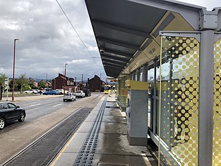
Edge Lane is a tram stop on the East Manchester Line (EML) of Greater Manchester's light-rail Metrolink system. It opened on 11 February 2013, after a three-day free trial for local residents. The station was constructed as part of Phase 3a of the Metrolink's expansion, and is located at the junction of Manchester Road and Edge Lane, just inside the border of Droylsden, Tameside, England.

Droylsden is a tram stop on the East Manchester Line (EML) of Greater Manchester's light-rail Metrolink system. It opened on 11 February 2013, after a three-day free trial for local residents. The stop was constructed as part of Phase 3a of the Metrolink's expansion, and is located in Droylsden town centre, a part of Tameside, England.

Cemetery Road is a tram stop on the East Manchester Line (EML) of Greater Manchester's light-rail Metrolink system. It opened on 11 February 2013, after a three-day free trial for local residents. The station was constructed as part of Phase 3a of the Metrolink's expansion, and is located in Droylsden at the junction of Manchester Road and Cemetery Road, a part of Tameside, England.
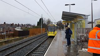
Abraham Moss is a tram stop in the suburban area of Cheetham Hill, Greater Manchester, England. It is on the Bury Line of Greater Manchester's light rail Metrolink system. The station gained funding approval in 2010 and replaced nearby Woodlands Road stop. It is close to the local library and college campus. The planning application for the station was lodged June 2010. Construction began on 18 October 2010 and the station became operational on 18 April 2011.

Ashton-under-Lyne bus station is a bus station that is located in the town of Ashton-under-Lyne in Greater Manchester, run by Transport for Greater Manchester. The bus station is situated on Wellington Road and adjoins the Arcades Shopping Centre. The bus station was opened in 2020 and replaced the previous bus station that was built on the current site.

The history of Manchester Metrolink begins with its conception as Greater Manchester's light rail system in 1982 by the Greater Manchester Passenger Transport Executive, and spans its inauguration in 1992 and the successive phases of expansion.

Newton Heath and Moston is a Manchester Metrolink tram stop on the Oldham and Rochdale Line (ORL), in the Newton Heath area of Manchester, England.
This timeline lists significant events in the history of Greater Manchester's light rail network called the Manchester Metrolink.

The East Manchester Line (EML) is a tram line of the Manchester Metrolink in Greater Manchester, England, running from Manchester to Ashton-under-Lyne via Droylsden and Audenshaw. The line opened in 2013 as part of phase three of the system's expansion.

Zone 1 of the Manchester Metrolink light rail network is the heart of the system where all of the other lines converge. Its boundaries approximately mirror the city's Inner Ring Road. Within Zone 1, first opened in 1992 as the City Zone, trams largely run along semi-pedestrianised streets rather than on their own separate alignment.


