South Manchester Line

Last updated

South Manchester Line
Metrolink tram arriving at East Didsbury, geograph-4719836-by-Alan-Murray-Rust.jpg
A M5000 tram approaching East Didsbury.
Overview
Locale Manchester
Termini
Stations8
Service
Type Tram/Light rail
System Manchester Metrolink
Rolling stock M5000
History
Opened7 July 2011 (Trafford Bar to St. Werburgh’s Road)
23 May 2013 (St. Werburgh’s Road to East Didsbury)
Technical
Line length4.4 miles (7.1 km)
CharacterReopened former railway trackbed
Track gauge 1,435 mm (4 ft 8+12 in) standard gauge
Electrification 750 volts DC overhead
Operating speed50 mph (80km/h)
Route map

Contents

BSicon uCONTg.svg
BSicon udCONTgq.svg
BSicon uABZgr.svg
BSicon uHST.svg
0:12
Firswood
BSicon uHST.svg
0:10
Chorlton
BSicon uHST.svg
0:09
St Werburgh's Road
BSicon udCONTgq.svg
BSicon uABZgr.svg
BSicon uHST.svg
0:07
Withington
BSicon uHST.svg
0:05
Burton Road
BSicon uHST.svg
0:04
West Didsbury
BSicon uHST.svg
0:02
Didsbury Village
BSicon dCONTgq.svg
BSicon umKRZu.svg
BSicon dCONTfq.svg
BSicon uKBHFe.svg
0:00
East Didsbury BSicon PARKING.svg BSicon BICYCLE.svg ( National Rail logo.svg

The South Manchester Line (SML) is a tram line of the Manchester Metrolink in Manchester, England, running from Manchester city centre to Didsbury. The line opened as far as St. Werburgh's Road in 2011 and then to East Didsbury in 2013 as part of phase three of the system's expansion, along a former railway trackbed.

Route

Map of the route South Manchester Line.png
Map of the route

From Manchester city centre, the line follows the Altrincham Line as far as Trafford Bar, after which it diverges south-east on a grade separated junction, passing the Trafford Metrolink tram depot. The line then continues south-east along a former railway alignment serving stops at Firswood, Chorlton and St Werburgh's Road. This stretch is shared with trams on the Airport Line, which diverges south just after St Werburgh's Road. [1]

The line then continues south-east serving stops at Withington, Burton Road, West Didsbury and Didsbury Village, to its terminus at East Didsbury, which is a short distance away from East Didsbury railway station. [2]

History

Map of CLC lines running into Manchester, The MSDR is to the left of the map. Midland to Manchester.jpg
Map of CLC lines running into Manchester, The MSDR is to the left of the map.

The line was originally a suburban railway, the Manchester South District Railway (MSDR), which was opened by the Midland Railway in 1880, in order to allow Midland Railway expresses from London to reach Manchester Central station. The line ran south from Manchester Central to Stockport Tiviot Dale. The line was partially transferred to the ownership of the Cheshire Lines Committee in 1891, and remained in their ownership until nationalisation in 1948. [3]

From the beginning, the line carried both a regular local service between Manchester Central and Stockport Tiviot Dale (these were known as the South District trains), trains to Buxton, and long distance Midland Railway expresses to London, running via Matlock and Derby. [3]

In 1892 the Fallowfield Loop Line was opened, from Chorlton to Guide Bridge; this had been built by the Manchester, Sheffield and Lincolnshire Railway (MSLR) so that trains from their main line between Manchester and Sheffield, via Woodhead, could access Manchester Central Station. [3]

In 1901 the Midland Railway opened a new line between Heaton Mersey and New Mills via Cheadle Heath. The new line was built to provide a faster route to the south for express services, avoiding Stockport Tiviot Dale. From this date, many South District services ran to Cheadle Heath, which was provided as an interchange station so that passengers could transfer between long distance and local trains. Express services were using the new route by July 1902. [3]

Local passenger traffic on the line went into sharp decline in the 1950s and 60s, leading to the closure of Tiviot Dale station, and withdrawal of the local South District services in January 1967. Express trains continued to run until May 1969, when Manchester Central station was closed, after this, the line between Chorlton and Cheadle Heath was closed, and the track lifted in 1970. The route between Manchester and Chorlton which formed part of the Fallowfield Loop Line, continued in use by freight trains until 1989, when the track was lifted. [3]

Construction work to re-open the former British Rail line in 2011 Construction of West Didsbury Metrolink Station (geograph 4292632).jpg
Construction work to re-open the former British Rail line in 2011

Proposals to reopen the line for light rail use had been made in the 1980s, [4] but the necessary funding only materialised in the 2000s, to reopen the line as far as East Didsbury as part of the third phase of the system's expansion, which also included new lines to Oldham and Rochdale, Ashton-under-Lyne and Manchester Airport. [5]

Clearance work started in October 2008, and the first stage; the 1.8 miles (3 km) from Trafford Bar to St Werburgh's Road was opened on 7 July 2011. [1]

The second stage, the 2.8 miles (4.5 km) from St Werburgh's Road to East Didsbury was opened on 23 May 2013. [6]

Proposed future development

The current terminus at East Didsbury; proposals have been made to extend the line to Stockport and beyond. East Didsbury Metrolink station.jpg
The current terminus at East Didsbury; proposals have been made to extend the line to Stockport and beyond.
The Stockport-Stalybridge line as a proposed line of Metrolink Metrolink map proposals.svg
The Stockport–Stalybridge line as a proposed line of Metrolink

Stockport extension

2004 proposal

An extension to the line from East Didsbury to Stockport was planned in 2004, and GMPTE applied for powers to build it. However, the process came to a halt when the big bang extension was stopped. [7]

The proposed extension would have reused some of the former railway alignment. However some of it was built on or filled in after closure, making re-opening more difficult, so the proposed line would have included some new infrastructure and street running sections to take it into Stockport. In these plans, the line would have terminated at Stockport bus station. [7]

Tram-train proposal

Stockport MBC commissioned a study from the firm Atkins into the potential for the use of tram-trains on local railway lines in the area, which would be able to use both existing Metrolink lines, and existing heavy rail lines. The report, published in January 2015, proposed that the line from East Didsbury could be extended via a link to existing railway lines into both Stockport railway station, and to Hazel Grove railway station. [8]

Services

As of February 2017, the following services operate on the East Didsbury Line: [9]

These two services combined mean that trams operate every six minutes between central Manchester and East Didsbury during Monday to Saturday daytimes.

Related Research Articles

<span class="mw-page-title-main">Heaton Mersey</span> Suburb of Stockport, Greater Manchester, England

Heaton Mersey is a suburb of Stockport, Greater Manchester, England. It is situated on the north-western border of Stockport, adjacent to Didsbury and Burnage which are in the City of Manchester.

<span class="mw-page-title-main">Altrincham Interchange</span> Railway, bus and tram interchange in Greater Manchester, England

Altrincham Interchange is a transport hub in Altrincham, Greater Manchester, England. It consists of a bus station on Stamford New Road, a Northern Trains-operated heavy rail station on the Mid-Cheshire Line, and a light rail stop which forms the terminus of Manchester Metrolink's Altrincham line. The original heavy rail element of the station was opened by the Manchester, South Junction and Altrincham Railway as Altrincham and Bowdon railway station in April 1881, changing to Altrincham railway station in May 1974. The Metrolink element opened in June 1992. The Interchange underwent a complete redevelopment, at a cost of £19 million, starting in mid-July 2013. The new bus station opened officially on 7 December 2014.

<span class="mw-page-title-main">Chorlton tram stop</span> Manchester Metrolink tram stop

Chorlton is a stop on the South Manchester Line (SML) and Airport Line of the Metrolink light-rail system in Chorlton-cum-Hardy, Manchester, England. It was built as part of Phase 3a of the network's expansion, and opened on 7 July 2011 on a section of the former Cheshire Lines Committee railway.

<span class="mw-page-title-main">Fallowfield Loop railway line</span> Disused railway line in south Manchester, England

The Fallowfield Loop railway line was a local railway route in south Manchester, England. Trains on the Manchester, Sheffield and Lincolnshire Railway (MS&LR) line from Sheffield Victoria and Guide Bridge used the Loop to access Manchester Central. Some express trains, including the Harwich-Liverpool boat train, used the line.

<span class="mw-page-title-main">Stockport, Timperley and Altrincham Junction Railway</span>

The Stockport, Timperley and Altrincham Junction Railway (ST&AJR) was authorised by an Act of Parliament, passed on 22 July 1861 to build a 8 miles 17 chains (13.2 km) railway from Stockport Portwood to Altrincham.

<span class="mw-page-title-main">Baguley railway station</span> Disused railway station in Manchester, England

Baguley railway station was a station in the south of Manchester, England, at the extreme western edge of Baguley near the southern end of Brooklands Road where Shady Lane crossed the railway line.

<span class="mw-page-title-main">Firswood tram stop</span> Manchester Metrolink tram stop

Firswood is a tram stop on the South Manchester Line (SML) and Airport Line of Greater Manchester's light-rail Metrolink system. Located in the Firswood area of Stretford, it was built as part of Phase 3a of the network's expansion, and opened on 7 July 2011.

<span class="mw-page-title-main">St Werburgh's Road tram stop</span> Manchester Metrolink tram stop

St Werburgh's Road is a tram stop on the South Manchester Line (SML) and Airport Line of Greater Manchester's light-rail Metrolink system in Chorlton-cum-Hardy, Manchester. It was built as part of Phase 3a of the network's expansion and opened on 7 July 2011.

<span class="mw-page-title-main">Didsbury railway station</span> Former railway station in England

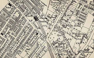
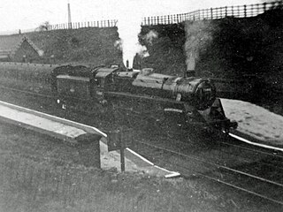
Didsbury railway station is a former station in Didsbury, in the southern suburbs of Manchester, England, United Kingdom. The station was located on Wilmslow Road, just north of the junction with Barlow Moor Road and opposite Didsbury Library. Nothing now remains of the old station buildings, which have been demolished, but the surviving white Portland stone clock tower is a local landmark. Didsbury is now served by Didsbury Village tram stop which is close to the site of the former railway station.

<span class="mw-page-title-main">Didsbury Village tram stop</span> Manchester Metrolink tram stop

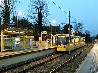
Didsbury Village is a tram stop on the South Manchester Line on the light-rail Metrolink network in Greater Manchester, England. It serves the South Manchester suburb of Didsbury.

<span class="mw-page-title-main">East Didsbury tram stop</span> Manchester Metrolink tram stop

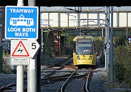
East Didsbury is a tram stop on Greater Manchester's light rail Metrolink system and the terminus of the system's South Manchester Line (SML). It is on the east side of Kingsway in East Didsbury, close to Manchester's boundary with Heaton Mersey in the Metropolitan Borough of Stockport. It was built as part of Phase 3b of the network's expansion and opened on 23 May 2013.

<span class="mw-page-title-main">Withington tram stop</span> Manchester Metrolink tram stop

Withington is a tram stop on the South Manchester Line (SML) of Greater Manchester's light-rail Metrolink system. It is located on the west side of Princess Road on the fringe of Withington in south Manchester, England.

<span class="mw-page-title-main">Burton Road tram stop</span> Manchester Metrolink tram stop

Burton Road is a stop on the South Manchester Line of Greater Manchester's light rail Metrolink system. It is located on Burton Road, on the border of the suburbs of Withington and West Didsbury in Manchester, England.

<span class="mw-page-title-main">History of Manchester Metrolink</span>

The history of Manchester Metrolink begins with its conception as Greater Manchester's light rail system in 1982 by the Greater Manchester Passenger Transport Executive, and spans its inauguration in 1992 and the successive phases of expansion.

<span class="mw-page-title-main">Withington and West Didsbury railway station</span> Former railway station in England

Withington and West Didsbury railway station is a former station in West Didsbury, in the southern suburbs of Manchester, England, United Kingdom. The station was located on Lapwing Lane, close to the junction with Palatine Road and opposite Withington Town Hall. Nothing now remains of the old station buildings, which have been demolished. West Didsbury is now served by West Didsbury tram stop which is approximately 85 metres (279 ft) further down the line from the original railway station.

<span class="mw-page-title-main">Manchester South District Railway</span> Former British railway operator

The Manchester South District Railway (MSDR) was a British railway company that was formed in 1873. It was formed by a group of landowners and businessmen in the south of Manchester, England, with the purpose of building a new railway line through the city's southern suburbs.

<span class="mw-page-title-main">Proposed developments of Manchester Metrolink</span> Development of Manchester Metrolink light rail system

This is a list of confirmed or proposed future developments of the Manchester Metrolink light rail system in Greater Manchester, England.

References

  1. 1 2 "Manchester, City South". LRTA. Retrieved 17 January 2016.
  2. "Manchester and Chorlton to East Didsbury". LRTA. Retrieved 17 January 2016.
  3. 1 2 3 4 5 "Station Name: CHORLTON-CUM-HARDY". Disused Stations. Retrieved 18 January 2016.
  4. Greater Manchester Passenger Transport Executive (1984). "Light Rapid Transit in Greater Manchester". GMPTE. - publicity brochure
  5. "Metrolink History 2". LRTA. Retrieved 21 January 2016.
  6. "South Manchester Line". Metrolink. Retrieved 21 January 2016.
  7. 1 2 "Metrolink, East Didsbury to Stockport". LRTA. Archived from the original on 1 February 2016. Retrieved 27 January 2016.
  8. "Stockport Rail Strategy" (PDF). Stockport Rail Strategy Stockport Metropolitan Borough Council/Atkins. pp. 45–49. Retrieved 26 March 2018.
  9. "Transport for Greater Manchester tram times". TfGM. Retrieved 27 January 2016.
Template:Attached KML/South Manchester Line
KML is from Wikidata