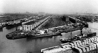
Manchester docks were a series of nine docks in Salford, Stretford and Manchester at the east end of the Manchester Ship Canal in North West England. They formed part of the Port of Manchester from 1894 until their closure in 1982. The docks marked the upper reaches of the ship canal, and were a destination for both coastal and ocean-bound vessels carrying cargo and a limited number of passengers, often travelling to and from Canada.

Castleton railway station serves Castleton in the Metropolitan Borough of Rochdale, Greater Manchester, England. It is 8¾ miles (14 km) north of Manchester Victoria on the Caldervale Line operated and managed by Northern.

Market Street is one of the principal retail streets in Manchester, England. It runs from its junction with Piccadilly and Mosley Street, close to Piccadilly Gardens, in the east to where it meets St. Mary's Gate at the crossroads with Exchange Street and New Cathedral Street in the west. St Mary's Gate then continues to where it meets Deansgate (A56). Other major streets crossed are High Street, Corporation Street, Cross Street and Fountain Street.

The Manchester–Southport line is a railway line in the north-west of England, operated by Northern Trains. It was originally built as the Manchester and Southport Railway. Starting at the city centre stations of Manchester Victoria and Manchester Piccadilly, it runs in a north-western direction through the towns, villages and suburbs of the City of Salford and Bolton. It then proceeds in the same direction through the small rural villages of West Lancashire, before ending on the Irish Sea coast at the resort town of Southport.

Trafford Bar is a tram stop on Greater Manchester's light rail system, Metrolink, at the junction of Talbot Road and Seymour Grove in Old Trafford. It opened on 15 June 1992 as part of Phase 1 of Metrolink's expansion, before which it was a mainline railway station.

Exchange Quay is a tram stop on the Eccles Line of Greater Manchester's light rail Metrolink system. It is located in the Salford Quays area, in North West England, and opened on 12 June 1999 as part of Phase 2 of the system's expansion. The stop serves the Exchange Quay office complex and the surrounding area. It is also often used as a stop for Old Trafford football stadium.

Anchorage tram stop is on the Eccles Line of Greater Manchester's light rail Metrolink system, in the Salford Quays area, in North West England. It opened on 12 June 1999 as part of Phase 2 of the system's expansion. The Anchorage name is a reference to The Anchorage building alongside, a large office block built at the end of Salford's former Dock 9 in 1991, sometime before the tram's arrival.

Harbour City is a tram stop on the Eccles Line of Greater Manchester's light rail Metrolink system. It is located in the Salford Quays area, in North West England, and opened on 12 June 1999 as part of Phase 2 of the system's expansion.

Salford Quays tram stop is a stop on Greater Manchester's light rail Metrolink system. It is located beside Salford Quays, on Metrolink's Eccles Line. It opened as part of Phase 2 of the system's expansion, on 12 June 1999.
Broadway is a tram stop on the Eccles Line of Greater Manchester's light rail Metrolink system. It opened to passengers on 12 June 1999 as part of Phase 2 of the network's expansion, and is located in the Salford Quays area of the City of Salford, in North West England.
Langworthy is a tram stop on the Eccles Line of Greater Manchester's light rail Metrolink system. It opened to passengers on 12 June 1999, as part of Phase 2 of the network's expansion, in the Langworthy area of Salford, in North West England.
Drake Street tram stop was a proposed tram stop for Greater Manchester's Metrolink light rail system, that was to be created to serve passengers boarding and alighting at Drake Street in Rochdale, England. It was also known by the name Wet Rake tram stop, and was set to be located on the Oldham and Rochdale Line between Rochdale railway station and Rochdale Town Centre tram stop.

MediaCityUK tram stop is a stop on the Manchester Metrolink light rail system. It is located in MediaCityUK, in Salford. The stop serves MediaCityUK, The Lowry, the Imperial War Museum North and other parts of Salford Quays. It is at the end of a short spur from the Eccles Line.
Woodhouse Park tram stop was a proposed Metrolink tram stop on the phase 3b plans to Manchester Airport. It was due to open in 2016 but was dropped from plans. The tram stop would have served the Woodhouse Park area of Wythenshawe in Greater Manchester.
Haveley tram stop was a proposed tram stop on the phase 3b plans to Manchester Airport which would have been located immediately east of the M56 motorway. It was originally due to open in 2016 but was dropped from the plans.
Hough End tram stop was a proposed tram stop on the phase 3b plans to Manchester Airport. It was originally due to open in 2016 but was dropped from the plans.

The Trafford Centre is a tram stop built for Greater Manchester's Metrolink light rail system, built to serve passengers boarding and alighting at the Trafford Centre on the Trafford Park Line. Previously known as intu Trafford Centre, the tram terminus received the name The Trafford Centre after intu ceased ownership of the shopping centre, the tram stop's namesake. The stop is located adjacent to Barton Dock Road between Ellesmere Circle and Bright Circle.
Salford Reds is a proposed station on a new line of the Metrolink light rail system in Greater Manchester, England, close to Salford City Stadium, home to Salford Red Devils rugby league and Sale Sharks rugby union clubs.

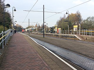
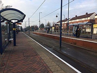
The Eccles Line is a tram line of the Manchester Metrolink in Greater Manchester running from Manchester to Eccles via Salford Quays, with a short spur to MediaCityUK. It was opened in phases during 1999–2000 as part of the second phase of the system's development. The spur to MediaCityUK was opened in 2010. The line contains a mixture of reserved track beds and a street running section.

This is a list of confirmed or proposed future developments of the Manchester Metrolink light rail system.

