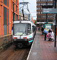
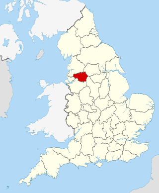
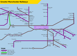
Manchester Metrolink is a tram/light rail system in Greater Manchester, England. The network has 99 stops along 64 miles (103 km) of standard-gauge route, making it the most extensive light rail system in the United Kingdom. Over the 2023/24 financial year 42 million passenger journeys were made on the system.
Transport for Greater Manchester (TfGM) is a local government body responsible for co-ordinating transport services throughout Greater Manchester in North West England. It is an executive arm of the Greater Manchester Combined Authority (GMCA), the city region's administrative authority. The strategies and policies of Transport for Greater Manchester are set by the GMCA and its Greater Manchester Transport Committee (GMTC). The committee is made up of 33 councillors appointed from the ten Greater Manchester boroughs, as well as the Mayor of Greater Manchester.

Manchester Airport station is a railway, tram, bus and coach station at Manchester Airport, England which opened at the same time as the second air terminal in 1993. The station is 9+3⁄4 miles (15.7 km) south of Manchester Piccadilly, at the end of a short branch from the Styal line via a triangular junction between Heald Green and Styal stations. Manchester Metrolink tram services were extended to the airport in 2014 and operate to Manchester Victoria.

Free bus is a zero-fare bus system that operates in Greater Manchester. The system was first introduced in Manchester city centre in 2002, with three routes linking the city's major thoroughfares and stations with its main commercial, financial and cultural districts.

St Peter's Square is a tram stop in St Peter's Square in Manchester city centre, England. It opened on 27 April 1992 and is in Zone 1 of Greater Manchester's Metrolink light rail system.

Altrincham Interchange is a transport hub in Altrincham, Greater Manchester, England. It consists of a bus station on Stamford New Road, a Northern Trains-operated heavy rail station on the Mid-Cheshire Line, and a light rail stop which forms the terminus of Manchester Metrolink's Altrincham line. The original heavy rail element of the station was opened by the Manchester, South Junction and Altrincham Railway as Altrincham and Bowdon railway station in April 1881, changing to Altrincham railway station in May 1974. The Metrolink element opened in June 1992. The Interchange underwent a complete redevelopment, at a cost of £19 million, starting in mid-July 2013. The new bus station opened officially on 7 December 2014.

Navigation Road is a station that serves both Northern Trains and Manchester Metrolink trams located in the east of Altrincham, in Greater Manchester, England. It consists of a Northern Trains-operated bidirectional heavy rail platform on the Mid-Cheshire Line opposite a bidirectional light rail platform on the Altrincham Line of Greater Manchester's Metrolink network. The original heavy rail station was opened by the Manchester, South Junction and Altrincham Railway in 1931 as a pair of single-face platforms, and in 1992 one was given over to the Metrolink network. A level crossing operates at the southern end of the station.

Sale is a tram stop on the Altrincham Line of the Metrolink light-rail system in Sale, Greater Manchester, England. It opened on 15 June 1992 as part of Phase 1 of Metrolink's expansion. Prior to this, it was a railway station on the Manchester, South Junction and Altrincham Railway (MSJAR) line. It was built by John Brogden, who was a local builder in the Sale area.
Cornbrook tram stop is a tram stop on Greater Manchester's light rail Metrolink system in the Cornbrook area of Manchester, England. It is an interchange station, allowing passenger transfer between the network's Altrincham, Eccles, Airport, Trafford Park and South Manchester lines. The station opened on 6 December 1999 for interchange only and allowed street-level entry and exit to the public from 3 September 2005. It takes its name from Cornbrook Road, between the A56 and Pomona Docks on the Manchester Ship Canal, and was built on what was a Cheshire Lines Committee route to Manchester Central railway station. The stop is one of the most used on the Metrolink network.

Mosley Street was a tram stop in the City Zone of Greater Manchester's Metrolink light rail system which closed on 18 May 2013. It was located on Mosley Street in Manchester city centre and was the last unidirectional stop on the Metrolink, with a single platform serving southbound passengers travelling towards Altrincham Interchange, Eccles Interchange, MediaCityUK and St Werburgh's Road only.
Shudehill Interchange is a transport hub between Manchester Victoria station and the Northern Quarter in Manchester city centre, England, which comprises a Metrolink stop and a bus station.

Ashton-under-Lyne bus station is a bus station that is located in the town of Ashton-under-Lyne in Greater Manchester, run by Transport for Greater Manchester. The bus station is situated on Wellington Road and adjoins the Arcades Shopping Centre. The bus station was opened in 2020 and replaced the previous bus station that was built on the current site.

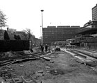
The history of Manchester Metrolink begins with its conception as Greater Manchester's light rail system in 1982 by the Greater Manchester Passenger Transport Executive, and spans its inauguration in 1992 and the successive phases of expansion.

Exchange Square is a tram stop on the Manchester Metrolink's Second City Crossing line, and opened on 6 December 2015 as part of Phase 2CC of the network's expansion. It is located by the main entrance to the Manchester Arndale shopping centre, and is also close to the Printworks.
The Manchester station group is a station group of four railway stations in Manchester city centre, England; this consists of Manchester Piccadilly, Manchester Oxford Road, Manchester Victoria and Deansgate. The station group is printed on national railway tickets as MANCHESTER STNS. For passengers travelling from one of the 91 National Rail stations in Greater Manchester, the four stations are printed as MANCHESTER CTLZ which additionally permits the use of Metrolink tram services in Zone 1.
This timeline lists significant events in the history of Greater Manchester's light rail network called the Manchester Metrolink.

The Bury Line is a light rail/tram line on the Manchester Metrolink in Greater Manchester. It runs from Manchester Victoria station to Bury Interchange in the north. The entire line runs along a converted heavy rail line, and was reopened with the Altrincham Line, another Metrolink line converted from heavy rail, as part of Phase 1 of the Metrolink's expansion.

This is a list of confirmed or proposed future developments of the Manchester Metrolink light rail system in Greater Manchester, England.

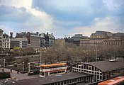
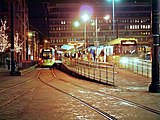
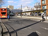
Zone 1 of the Manchester Metrolink light rail network is the heart of the system where all of the other lines converge. Its boundaries approximately mirror the city's Inner Ring Road. Within Zone 1, first opened in 1992 as the City Zone, trams largely run along semi-pedestrianised streets rather than on their own separate alignment.