Cornbrook tram stop

Last updated

Cornbrook
Metrolink station
Cornbrook platforms.jpg
General information
LocationCornbrook, Manchester
England
Coordinates 53°28′12″N2°16′03″W / 53.4700°N 2.2675°W / 53.4700; -2.2675
Grid reference SJ823971
Line(s) Altrincham Line
Eccles Line
Platforms2 (island)
Other information
StatusIn operation
Fare zone1/2
History
Original company Manchester Metrolink
Key dates
6 December 1999Opened (for interchange only)
3 September 2005Opened (for entry and exit)
Location
Cornbrook tram stop

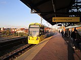
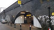
Cornbrook tram stop is a tram stop on Greater Manchester's light rail Metrolink system in the Cornbrook area of Manchester, England. It is an interchange station, allowing passenger transfer between the network's Altrincham, Eccles, Airport, Trafford Park and South Manchester lines. The station opened on 6 December 1999 for interchange (line transfers) only and allowed street-level entry and exit to the public from 3 September 2005. It takes its name from Cornbrook Road, between the A56 and Pomona Docks on the Manchester Ship Canal, and was built on what was a Cheshire Lines Committee route to Manchester Central railway station. The stop is one of the most used on the Metrolink network. [1]

Contents

History

The stop is named after the now culverted Corn Brook, a tributary of the River Irwell which runs through the area. [2]

The stop opened with the Eccles extension on 6 December 1999 with two through platforms and a Manchester facing bay platform for terminating trams. Cornbrook was unique when opened as there was no access to/from the street, the stop being used for transfer between Bury-Altrincham line trams and Eccles Line trams. This was due to security issues and a low estimated usage.

Because of a rise in the local population due to new residential developments, particularly on Ellesmere Street, the stop's emergency exit staircase to the street was converted into a full passenger entrance/exit, which opened on 3 September 2005. There are plans to relocate the entrance as part of the "Cornbrook Hub" redevelopment. [3]

During August 2009, the track layout was extensively remodelled to accommodate the MediaCityUK tram service and as a result the track was removed from the bay platform reducing the number of platforms to 2. However the infrastructure remains and the platform could be reinstated if the need arises.

This is the second station in this locality as Cornbrook railway station was opened to serve Pomona Gardens on the south side of Cornbrook Road on 1 June 1856 by the Manchester, South Junction and Altrincham Railway (MSJAR), which runs parallel to the Metrolink at this point. The first station closed on 31 May 1865.

Services

Services run every 12 minutes on all routes. Some routes (as indicated) only operate during peak times.

Preceding station Manchester metrolink logo.PNG Manchester Metrolink Following station
Trafford Bar
towards East Didsbury
East Didsbury–Shaw (peak only) Deansgate-Castlefield
East Didsbury–Rochdale Deansgate-Castlefield
Trafford Bar Manchester Airport–Victoria Deansgate-Castlefield
towards Victoria
Trafford Bar
towards Altrincham
Altrincham–Bury (peak only) Deansgate-Castlefield
towards Bury
Altrincham–Piccadilly Deansgate-Castlefield
towards Piccadilly
Altrincham–Etihad Campus (evenings and Sundays only) Deansgate-Castlefield
towards Etihad Campus
Pomona
towards Eccles
Eccles–Ashton (peak only) Deansgate-Castlefield
Eccles–Ashton via MediaCityUK (off-peak only)
Pomona
towards MediaCityUK
MediaCityUK–Etihad Campus (peak only) Deansgate-Castlefield
towards Etihad Campus
Pomona The Trafford Centre–Deansgate Deansgate-Castlefield
Terminus

Connecting bus routes

Cornbrook station is served by bus services on nearby Chester Road. Stagecoach Manchester service 255 runs to Partington via Stretford and Urmston. Services run to Manchester, terminating at Piccadilly Gardens. [4]

Related Research Articles

<span class="mw-page-title-main">Manchester Piccadilly station</span> Railway station in Manchester, England

Manchester Piccadilly is the main railway station of the city of Manchester, in the metropolitan county of Greater Manchester, England. Opened originally as Store Street in 1842, it was renamed Manchester London Road in 1847 and became Manchester Piccadilly in 1960. Located to the south-east of the city centre, it hosts long-distance intercity and cross-country services to national destinations including London, Birmingham, Nottingham, Glasgow, Edinburgh, Cardiff, Bristol, Exeter, Plymouth, Reading, Southampton and Bournemouth; regional services to destinations in Northern England including Liverpool, Leeds, Sheffield, Newcastle and York; and local commuter services around Greater Manchester. It is one of 19 major stations managed by Network Rail. The station has 14 platforms: 12 terminal and two through platforms. Piccadilly is also a major interchange with the Metrolink light rail system with two tram platforms in its undercroft.

<span class="mw-page-title-main">Manchester Metrolink</span> Tram system in Greater Manchester, England

Manchester Metrolink is a tram/light rail system in Greater Manchester, England. The network has 99 stops along 64 miles (103 km) of standard-gauge route, making it the most extensive light rail system in the United Kingdom. Over the 2022/23 financial year 36 million passenger journeys were made on the system.

<span class="mw-page-title-main">Rochdale railway station</span> Railway station and tram stop in Greater Manchester, England

Rochdale railway station is a multi-modal transport hub in Rochdale, Greater Manchester, England. It consists of a Northern-operated heavy rail station on the Caldervale Line, and an adjoining light rail stop on Metrolink's Oldham and Rochdale Line. The original heavy-rail element of the station was opened by the Manchester and Leeds Railway in 1839 0.5 miles (0.80 km) to the south of Rochdale town centre. The Metrolink element opened in February 2013. Further changes to the station are planned as part of the Northern Hub rail-enhancement scheme.

<span class="mw-page-title-main">Altrincham Interchange</span> Railway, bus and tram interchange in Greater Manchester, England

Altrincham Interchange is a transport hub in Altrincham, Greater Manchester, England. It consists of a bus station on Stamford New Road, a Northern Trains-operated heavy rail station on the Mid-Cheshire Line, and a light rail stop which forms the terminus of Manchester Metrolink's Altrincham line. The original heavy rail element of the station was opened by the Manchester, South Junction and Altrincham Railway as Altrincham and Bowdon railway station in April 1881, changing to Altrincham railway station in May 1974. The Metrolink element opened in June 1992. The Interchange underwent a complete redevelopment, at a cost of £19 million, starting in mid-July 2013. The new bus station opened officially on 7 December 2014.

<span class="mw-page-title-main">Navigation Road station</span> Railway station in Greater Manchester, England

Navigation Road is a station that serves both Northern Trains and Manchester Metrolink located in the east of Altrincham, in Greater Manchester, England. It consists of a Northern Trains-operated heavy rail station on the Mid-Cheshire Line, and an adjoining light rail stop on the Altrincham Line of Greater Manchester's Metrolink network. The original heavy rail element of the station was opened by the Manchester, South Junction and Altrincham Railway in 1931, and the Metrolink element opened in 1992. A level crossing operates at the southern end of the station.

<span class="mw-page-title-main">Manchester, South Junction and Altrincham Railway</span> Suburban railway in Manchester

The Manchester South Junction and Altrincham Railway (MSJ&AR) was a suburban railway which operated an 8+12-mile (14 km) route between Altrincham in Cheshire and Manchester London Road railway station in Manchester.

<span class="mw-page-title-main">Dane Road tram stop</span> Metrolink stop in South Manchester

Dane Road is a tram stop on the Altrincham Line of Greater Manchester's Metrolink light rail system. It is located on Dane Road in northern Sale, Greater Manchester, England. It opened on 15 June 1992 as part of Phase 1 of Metrolink's expansion.

<span class="mw-page-title-main">Stretford tram stop</span> Manchester Metrolink tram stop

Stretford is a tram stop on the Altrincham Line of Greater Manchester's light-rail Metrolink system. It is located in Stretford, on the corner of Chester Road and Edge Lane. It opened on 15 June 1992 as part of Phase 1 of Metrolink's expansion.

<span class="mw-page-title-main">Old Trafford tram stop</span> Manchester Metrolink tram stop

Old Trafford is a tram stop on the Altrincham Line of the Metrolink light rail system in Old Trafford, Greater Manchester, England.

<span class="mw-page-title-main">Deansgate-Castlefield tram stop</span> Manchester Metrolink tram stop

Deansgate-Castlefield is a tram stop on Greater Manchester's Metrolink light rail system, on Deansgate in the Castlefield area of Manchester city centre. It opened on 27 April 1992 as G-Mex tram stop, taking its name from the adjacent G-Mex Centre, a concert, conference and exhibition venue; the G-Mex Centre was rebranded as Manchester Central in 2007, prompting the Metrolink stop to be renamed on 20 September 2010. The station underwent redevelopment in 2014–15 to add an extra platform in preparation for the completion of the Second City Crossing in 2016–17.

<span class="mw-page-title-main">Pomona tram stop</span> Metrolink tram stop in Manchester, England

Pomona is a tram stop located just east of the junction of the Eccles Line and Trafford Park Line of Greater Manchester's light rail system, known as Metrolink. It opened to passengers on 6 December 1999, as part of Phase 2 of the network's expansion, at Pomona Docks in Old Trafford.

<span class="mw-page-title-main">History of Manchester Metrolink</span>

The history of Manchester Metrolink begins with its conception as Greater Manchester's light rail system in 1982 by the Greater Manchester Passenger Transport Executive, and spans its inauguration in 1992 and the successive phases of expansion.

This timeline lists significant events in the history of Greater Manchester's light rail network called the Manchester Metrolink.

<span class="mw-page-title-main">Bury Line</span> Manchester Metrolink line

The Bury Line is a tram line of the Manchester Metrolink running from Manchester city centre to Bury in Greater Manchester. Originally a railway line, it was, along with the Altrincham Line, converted into a tram line during 1991–92, as part of the first phase of the Metrolink system.

<span class="mw-page-title-main">Altrincham Line</span> Manchester Metrolink line

The Altrincham Line is a tram line of the Manchester Metrolink running from Manchester to Altrincham in Greater Manchester. Originally a railway line, it was, along with the Bury Line, converted into a tramway during 1991–92, as part of the first phase of the Metrolink system.

<span class="mw-page-title-main">Eccles Line</span> Manchester Metrolink line

The Eccles Line is a tram line of the Manchester Metrolink in Greater Manchester running from Manchester to Eccles via Salford Quays, with a short spur to MediaCityUK. It was opened in phases during 1999–2000 as part of the second phase of the system's development. The spur to MediaCityUK was opened in 2010. The line contains a mixture of reserved track beds and a street running section.

<span class="mw-page-title-main">Airport Line (Manchester Metrolink)</span> Manchester Metrolink line

The Airport Line is a tram line of the Manchester Metrolink in Manchester, England, running from Manchester city centre to Manchester Airport via Wythenshawe. It opened in November 2014 as part of phase three of the system's expansion.

<span class="mw-page-title-main">Proposed developments of Manchester Metrolink</span> Development of Manchester Metrolink light rail system

This is a list of confirmed or proposed future developments of the Manchester Metrolink light rail system in Greater Manchester, England.

<span class="mw-page-title-main">Zone 1 (Manchester Metrolink)</span>

Zone 1 of the Manchester Metrolink light rail network is the heart of the system where all of the other lines converge. Its boundaries are broadly equivalent to those of Manchester city centre, and approximately mirror the city's Inner Ring Road. Within Zone 1, first opened in 1992 as the City Zone, trams largely run along semi-pedestrianised streets rather than on their own separate alignment. The original route between the Altrincham and Bury lines ran to Victoria station via Market Street and High Street, and was soon joined by a branch to Piccadilly station by a three-way delta junction. A second route between the South-West and North-Eastern parts of the network was built to ease congestion on the original line. Opened in 2017, the Second City Crossing (2CC) added one additional stop to the network.

References

  1. "Transport Statistics Greater Manchester 2017 Public Transport Section". TfGM. 5 December 2019. Retrieved 14 December 2019.
  2. "Hidden Manchester Map". Hidden Manchester Map.
  3. "Archived copy". Archived from the original on 21 August 2014. Retrieved 21 August 2014.{{cite web}}: CS1 maint: archived copy as title (link)
  4. "Transport for Greater Manchester - Journey Planning - Network Maps". Transport for Greater Manchester. Archived from the original on 2 November 2012. Retrieved 10 September 2012.

Further reading