
Warwick County was a county in Southeast Virginia that was created from Warwick River Shire, one of eight created in the Virginia Colony in 1634. It became the City of Warwick on July 16, 1952. Located on the Virginia Peninsula on the northern bank of the James River between Hampton Roads and Jamestown, the area consisted primarily of farms and small unincorporated villages until the arrival of the Peninsula Extension of the Chesapeake and Ohio Railway in 1881 and development led by industrialist Collis P. Huntington.
Denbigh was a small unincorporated community in Warwick County, Virginia, USA, and was long the county seat. After a municipal consolidation in 1958, it became a neighborhood of the independent city of Newport News.

Seven Pines and the Seven Pines National Cemetery are located in the unincorporated town of Sandston in Henrico County, Virginia. Cemetery records state the name is derived from for a group of seven pine trees planted within the national cemetery in 1869 near the intersection of the old Williamsburg-Richmond Stage Road and the Nine Mile Road, however, the name "Seven Pines" pre-dates the establishment of the cemetery. Earlier maps and records, especially those from the American Civil War, commonly refer to the location as "Seven Pines." Today, the surrounding area is still referred to as "Seven Pines" although the local township is Sandston.
Barkerville Provincial Park is a former provincial park in British Columbia, Canada, protecting the museum town of Barkerville, capital of the Cariboo Gold Rush, and environs. In 2006, the BC Ministry of the Environment transferred ownership of the 136-acre park to the Ministry of Tourism, Sport and the Arts for park purposes.
Mulberry Island is located along the James River in the city of Newport News, Virginia, in southeastern Virginia at the confluence of the Warwick River on the Virginia Peninsula.

Falling Creek was an unincorporated location in Virginia, United States, along Interstate 95 near the point where a local tributary, Falling Creek, has its confluence with the James River. It was perhaps best known as the site of one of the toll barriers on the Richmond-Petersburg Turnpike, completed in 1958. In modern times, I-95 and the more recently built Pocahontas Parkway toll road now occupy much of the site. Nearby, at the northwestern edge, the old lost town of Port Warwick was located on the river before it was destroyed during the American Revolutionary War.
Warwick was an unincorporated town and port in Chesterfield County, Virginia, located on the navigable portion of the James River about 5 miles south of downtown Richmond, Virginia. Due to a sandbar in the river, although the falls did not begin until the river reached Richmond and Manchester, Warwick was as far upriver as many ships of the day could safely navigate. Regarding navigation on the James River, in his Notes on the State of Virginia, written in 1781–82, then-Governor Thomas Jefferson stated "Vessels of 250 tons may go to Warwick"
Fulton Yard is a rail yard on CSX Transportation's Peninsula Subdivision in Richmond, Virginia. It has 13 tracks.
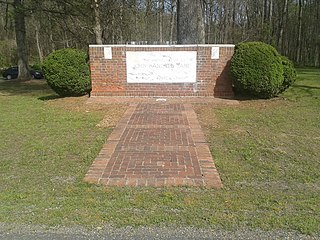
The Tabb Monument, dedicated in 1936, is a monument in Amelia County, Virginia dedicated to Virginia-born Catholic poet John Bannister Tabb. The marker, and the one-acre (4,000 m2) plot of land surrounding it, are managed as a state park by the Commonwealth of Virginia.

Parkhill is an unincorporated community in Butte County, California. It lies at an elevation of 1942 feet. Parkhill is located at 39°43′21″N121°29′48″W.
Broad Rock Manor is an unincorporated community in Richmond County, in the U.S. state of Virginia.
Fairway Acres is an unincorporated community in Richmond County, in the U.S. state of Virginia.
Cedar Fork is an unincorporated community in Caroline County, in the U.S. state of Virginia.
Coffey Corner is an unincorporated community in Caroline County, in the U.S. state of Virginia.
Kidds Fork is an unincorporated community in Caroline County, in the U.S. state of Virginia.
Lauraville is an unincorporated community in Caroline County, in the U.S. state of Virginia.
Peatross is an unincorporated community in Caroline County, in the U.S. state of Virginia.
Sorrell is an unincorporated community in Caroline County, in the U.S. state of Virginia.
Paradas is a municipality in the province of Seville, Spain.
Wuskwi Sipihk First Nation is a Swampy Cree First Nations band government whose reserve community is located northeast Birch River, Manitoba, along the western shores of Swan Lake. The Rural Municipality of Mountain (North) forms the western and southern borders of the reserve. As of April, 2011, the First Nation had a total registered population of 623 people, of which 197 people lived on their own Indian Reserve. The current Chief for the First Nation is Elwood Zastre.


