Waterloo is a Charleroi Metro station, located at the northern end of Charleroi downtown, in fare zone 1.
The station has 3 street entrances (two on each side of the Jules Hénin Avenue, one on the Jules Hiérnaux Square), leading to the lowest level. Platforms are located on the upper level and are accessible through escalators and stairs.
The station has one lateral platform which is currently not used (and not connected to any tram tracks). All current lines use a central platform. Waterloo is also the starting point of the partially built but unused Centenaire line.
Starting from Waterloo is a short track section running to the North and surfacing north of the Jules Hiérnaux Square, which would have been the starting point of pre-metro lines to Lodelinsart and Gosselies on one side, and Ransart and Heppignies on the other side. (A tram line to Gosselies, beginning at Piges, has been built since.)
The station features an extensive track network, allowing light rail vehicles to pass the station and reverse the travel direction by entering it from opposite direction (first bypassing it by a passing loop) or by travelling back after departing the station using a passing loop.
On the initial project plan for the Charleroi Pre-metro, the Waterloo station was called Nord (French for North).
Nearby points of interest
In the middle of the nearby Jules Hiérnaux Square is a Marsupilami statue which is a well-known Charleroi landmark.
Notre-Dame (Our Lady) hospital.
Université du Travail Higher education school.
Ville 2 Mall
Transfers
TEC Charleroi bus lines 4, 37, 71, 74, 722 and City-Bus.
A cross-platform interchange is a type of interchange between different lines at a metro station. The term originates with the London Underground; such layouts exist in other networks but are not commonly so named. In the United States and Canada, it is often referred to as a cross-platform transfer.
The Brussels Metro is a rapid transit system serving a large part of the Brussels-Capital Region of Belgium. It consists of four conventional metro lines and three premetro lines. The metro-grade lines are M1, M2, M5, and M6 with some shared sections, covering a total of 39.9 kilometres (24.8 mi), with 59 metro-only stations. The premetro network consists of three tram lines that partly travel over underground sections that were intended to be eventually converted into metro lines. Underground stations in the premetro network use the same design as metro stations. A few short underground tramway sections exist, so there is a total of 52.0 kilometres (32.3 mi) of underground metro and tram network. There are a total of 69 metro and premetro stations as of 2011.
Tennōji Station is a major railway station on the JR West Osaka Loop Line, Hanwa Line, Yamatoji Line, Osaka Metro Midōsuji Line, and Tanimachi Line, located in Tennōji-ku and Abeno-ku, Osaka, Japan, and Tennōji-ekimae Station is a railway station on the tram Hankai Uemachi Line in Abeno-ku, Osaka, Japan. They are also connected to Ōsaka Abenobashi Station on the Kintetsu Minami Osaka Line. It forms as one of Osaka's main railway terminals to the south for lines operated by West Japan Railway Company.
A passing loop or passing siding is a place on a single line railway or tramway, often located at or near a station, where trains or trams travelling in opposite directions can pass each other. Trains/trams going in the same direction can also overtake, provided that the signalling arrangement allows it. A passing loop is double-ended and connected to the main track at both ends, though a dead end siding known as a refuge siding, which is much less convenient, can be used. A similar arrangement is used on the gauntlet track of cable railways and funiculars, and in passing places on single-track roads.
An island platform is a station layout arrangement where a single platform is positioned between two tracks within a railway station, tram stop or transitway interchange. Island platforms are sometimes used between the opposite-direction tracks on twin-track route stations as they are cheaper and occupy less area than other arrangements. They are also useful within larger stations, where local and express services for the same direction of travel can be accessed from opposite sides of the same platform instead of side platforms on either side of the tracks, simplifying and speeding transfers between the two tracks.
The Brussels tramway network is a tram system serving a large part of the Brussels-Capital Region of Belgium. It is the 16th largest tram system in the world by route length, in 2017 providing 149.1 million journeys over routes 140.6 km (87.4 mi) in length. In 2018, it consisted of 18 tram lines. Brussels trams are operated by STIB/MIVB, the local public transport company.
Amsterdam Sloterdijk is a major railway junction to the west of Amsterdam Centraal station. It is at a rail-rail crossing, with an additional chord (Hemboog). It is on the railway line from Amsterdam Centraal to Haarlem and the last station before the junction where the line Amsterdam Centraal-Zaandam diverges from it and on the crossing west branch of the Amsterdam–Schiphol railway line between Schiphol and Amsterdam Centraal.
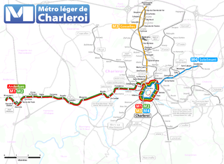
The Métro Léger de Charleroi is a 33-kilometre (21 mi) light rail network in Belgium. The system consists of a loop line around central Charleroi and three branches towards the suburbs of Gilly, Anderlues and Gosselies. Another branch to Châtelet was partially built, never entered service, but will finally do so in 2026.
Tramlijn 5 is a tram line operating between Amsterdam and Amstelveen in the Netherlands. Operated by the municipal transport company GVB, the route normally runs between Van Hallstraat in Amsterdam and Stadshart in the neighbouring municipality of Amstelveen. Tram line 5 connects several important areas of the city, including the Zuidas financial district and Leidseplein, and also provides a rapid tram route south of Amsterdam Zuid station to Stadshart, Amstelveen's town centre.
Simonis and Elisabeth are two interconnected Brussels Metro stations serving lines 2 and 6 on two different levels, as well as a tram and bus stop. Additionally, Simonis railway station is a railway station operated by the National Railway Company of Belgium (SNCB/NMBS). It is served by the Brussels Regional Express Network (RER/GEN) service.
Brussels has an extensive network of both private or public transportation means. Public transportation includes Brussels buses, trams, and metro, as well as a set of railway lines and railway stations served by public trains. Air transport is available via one of the city's two airports, and boat transport is available via the Port of Brussels. Bicycle-sharing and car-sharing public systems are also available. The city is relatively car-dependent by northern European standards and is considered to be the most congested city in the world according to the INRIX traffic survey.
The Line C is a line on the Frankfurt U-Bahn. It consists of the U6 and the U7.
Beaux-Arts is the largest station in the Charleroi Metro network, located in Charleroi downtown, in fare zone 1. Because of its situation on a slope, the station terminates on a viaduct at one end, and in a tunnel at the other end.
Piges is a Charleroi Metro station, located in Dampremy, in fare zone 1. The station is built on a viaduct and is accessed through escalators and stairs from a street entrance located on Chaussée de Bruxelles.
Soleilmont is a Charleroi Metro station located in Gilly, Belgium, opened on 27 February 2012 as part of the Soleilmont extension of the Gilly branch of the Charleroi Metro. The station, built at ground level, is the terminus of the Gilly branch and is an intermodal transport hub served by trams and buses and featuring a 200 spaces car park.
Line M1 is a line of the Charleroi Metro in Belgium operated by TEC Charleroi, running from the Monument tram stop in Anderlues to the metro loop around central Charleroi, before heading back to Anderlues. Line M1 was created on 27 February 2012 to replace former lines 88 and 89 after completion of the loop around central Charleroi. Introduction of new line numbers in February 2012 coincided with the formal association of colors to line numbers. The official color for line M1 is red.
Line M2 is a line of the Charleroi Metro in Belgium operated by TEC Charleroi, running from the Monument tram stop in Anderlues to the metro loop around central Charleroi, before heading back to Anderlues. Line M2 was created on 27 February 2012 to replace former lines 88 and 89 after completion of the loop around central Charleroi. Introduction of new line numbers in February 2012 coincided with the formal association of colors to line numbers. The official color for line M2 is green.
Line 4 is a line of the Charleroi Metro in Belgium operated by TEC Charleroi, running from Soleimont in Gilly to the loop around downtown Charleroi, before heading back to Soleilmont.
Line M3 is a line of the Charleroi Metro in Belgium operated by TEC Charleroi, running from Gosselies to the loop around downtown Charleroi, before heading back to Gosselies.
This page is based on this Wikipedia article Text is available under the CC BY-SA 4.0 license; additional terms may apply. Images, videos and audio are available under their respective licenses.