
Wharton County is a county located in the U.S. state of Texas. As of the 2020 census, its population was 41,570. Its county seat is Wharton. The county was named for brothers William Harris Wharton and John Austin Wharton.

Thomas James Churchill was an American soldier and politician who served as the 13th governor of Arkansas from 1881 to 1883. Before that, he was a senior officer of the Confederate States Army who commanded infantry in the Western and Trans-Mississippi theaters of the American Civil War.

The First Battle of Newtonia was fought on September 30, 1862, between Confederate soldiers commanded by Colonel Douglas H. Cooper and a Union column commanded by Brigadier General Frederick Salomon near Newtonia, Missouri, during the American Civil War. Cooper's force had moved into southwestern Missouri, and encamped near the town of Newtonia. The Confederate column was composed mostly of cavalry led by Colonel Joseph O. Shelby and a brigade of Native Americans. A Union force commanded by Brigadier General James G. Blunt moved to intercept Cooper's force. Blunt's advance force, led by Salomon, reached the vicinity of Newtonia on September 29, and attacked Cooper's position on September 30. A Union probing force commanded by Colonel Edward Lynde was driven out of Newtonia by Cooper's forces on the morning of the 30th.

The Battle of Round Mountain was the first battle in the Trail of Blood on Ice campaign for the control of Indian Territory during the American Civil War that occurred on November 19, 1861. Its main purpose was to prevent Union supporters of the Creek Nation, led by Opothleyahola from fleeing Indian Territory to the protection of Union forces in Kansas.
The Battle of Old Fort Wayne, also known as Maysville, Beattie's Prairie, or Beaty's Prairie, was an American Civil War battle on October 22, 1862, in Delaware County in what is now eastern Oklahoma.

The Colorado Territory was formally created in 1861 shortly before the bombardment of Fort Sumter sparked the American Civil War. Although sentiments were somewhat divided in the early days of the war, Colorado was only marginally a pro-Union territory. Colorado was strategically important to both the Union and Confederacy because of the gold and silver mines there as both sides wanted to use the mineral wealth to help finance the war. The New Mexico Campaign was a military operation conducted by Confederate Brigadier General Henry Sibley to gain control of the Southwest, including the gold fields of Colorado, the mineral-rich territory of Nevada and the ports of California. The campaign was intended as a prelude to an invasion of the Colorado Territory and an attempt to cut the supply lines between California and the rest of the Union. However, the Confederates were defeated at the Battle of Glorieta Pass in New Mexico and were forced to retreat back to Texas, effectively ending the New Mexico Campaign.
Elizabethtown, once known as Bugtown, is a ghost town located about fifteen miles southwest of Denton in Denton County, Texas, United States. The town derived its original name from the adjacent Elizabeth Creek. The creek starts in northeast Roanoke and ends near Rhome, Haslet, and Avondale.
Rosharon, is an unincorporated community and census-designated place (CDP) located entirely in Brazoria County, Texas, United States, at the intersection of Farm to Market Road 521 and Farm to Market Road 1462. As of the 2010 census, it had a population of 1,152. There are areas outside of the CDP, with Rosharon postal addresses, in Fort Bend County.

Caney Creek (Matagorda Bay) is a river in Texas that begins northwest of Wharton, flows generally southeast, and empties into the Gulf of Mexico near Sargent. The major waterway to the west is the Colorado River while the next major waterway to the east is the San Bernard River.
The San Antonio–El Paso Road, also known as the Lower Emigrant Road or Military Road, was an economically important trade route between the Texas cities of San Antonio and El Paso between 1849 and 1882. Mail, freight, and passengers traveled by horse and wagon along this road across the Edwards Plateau and dangerous Trans-Pecos region of West Texas.

Nottawa is a ghost town in northeastern Wharton County, in the U.S. state of Texas. The former community was situated in a rice-growing area midway between East Bernard and Lissie at the junction of U.S. Route 90 Alternate (US 90A) and Farm to Market Road 1164 (FM 1164). There was a gas compressor station on the site in 2016.
Round Mott or Round Mott Community is a ghost town in western Wharton County, in the U.S. state of Texas. The community was located northwest of El Campo on FM 1300. The settlement briefly had a post office in the 1880s. A school was in existence by 1905 and served the community until 1951. Only a private home, a cell phone tower and a disused church building remained at the site in 2015.
Osage is a ghost town in northwestern Colorado County in the U.S. state of Texas. The one-time settlement was situated on Harvey Creek near the junction of County Roads 205 and 208 a few miles to the northeast of Weimar. At the time of the Civil War, the community was substantial enough to provide a company of soldiers to a Texas regiment in the Confederate States Army. A notable school flourished in Osage starting in the 1870s, but in that decade the railroad was built through Weimar instead. By 1900, the local commercial establishments had moved to Weimar and the town faded out of existence. In 2013, the area was sparsely settled.

Peach Creek is a ghost town in Wharton County in the U.S. state of Texas. The former settlement was located along Peach Creek in the land grants belonging to Old Three Hundred settlers William Kincheloe and Alexander Jackson, Sr. During the Republic of Texas a post office was located at Peach Creek. Though it was hoped the community might become the county seat, that never happened and postal service stopped in 1847.
Preston is a ghost town in Wharton County in the U.S. state of Texas. The one-time settlement was located in the land grant belonging to Old Three Hundred settler John Huff near an important north–south trail. During the early years of the Republic of Texas, lots were sold and a town took shape. Postal service began in 1839 and ceased in 1857. The only evidence that a town existed is an old cemetery near Farm to Market Road 1096, (FM 1096) south of Iago.
Duke is a ghost town in Fort Bend County, in the U.S. state of Texas. The former settlement's location was west of Arcola along the BNSF Railway near Houston Southwest Airport. In 2014 the town site was no longer accessible by public roads.
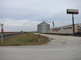
Mackay is an unincorporated community in central Wharton County, in the U.S. state of Texas. The once thriving community is located on U.S. Route 59, (US 59) southwest of Wharton near Wharton Regional Airport. Mackay began as a railroad stop near a large ranch in 1881 and saw an influx of immigrants beginning in 1907. The community had its own post office from 1921 to 1937, but most of the buildings were gone by 1990. There were two businesses and a grain silo at the site in 2014.
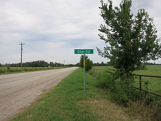
Don-Tol is a small unincorporated community in southeastern Wharton County, in the U.S. state of Texas. The community is located along FM 1301 southeast of Boling. There is a Don-Tol sign on FM 1301 at County Road 100. The name was used by Mexican workers to address William Toliver Taylor, the owner of a post-Civil War sugar cane plantation.
Monticello is an unincorporated community located in Sierra County, New Mexico, United States. Monticello is located on Alamosa Creek, 22 miles (35 km) northwest of Truth or Consequences. Monticello has a post office with ZIP code 87939.
Texas Hill Station is a site of a later Butterfield Overland Mail stagecoach station. It was one of several built in 1859 to increase the number of water stops and team changes along the drier and hotter sections of the route and was located about 2 miles east of Texas Hill.

