Fulshear is a city in northwestern Fort Bend County, Texas, United States, and is located on the western edge of the Houston–The Woodlands–Sugar Land metropolitan area. The population was 16,856 as of the 2020 census, and according to 2023 census estimates, the city is estimated to have a population of 43,317.

Kendleton is a city in western Fort Bend County, Texas, United States, located southwest of Sugar Land. It was established by emancipated slaves after the Civil War. The population was 343 at the 2020 census. As of 2011, Darryl Humphrey was the mayor of the city.

Manchaca is a census-designated place (CDP) in Travis County, Texas, United States. It is located 10 miles (16 km) southwest of downtown Austin. This was a new CDP for the 2020 census with a population of 2,266.
Newgulf is an unincorporated community in Wharton County, Texas, United States. According to the Handbook of Texas, the community had a population of ten in 2009. It is located within the Greater Houston metropolitan area.
Rosharon, is an unincorporated community and census-designated place (CDP) located entirely in Brazoria County, Texas, United States, at the intersection of Farm to Market Road 521 and Farm to Market Road 1462. As of the 2010 census, it had a population of 1,152. There are areas outside of the CDP, with Rosharon postal addresses, in Fort Bend County.
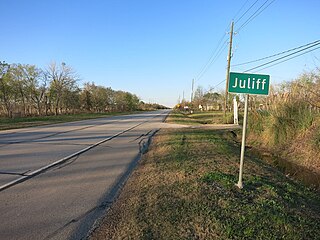
Juliff is an unincorporated community in Fort Bend County, Texas, United States. It is a part of the Greater Houston metropolitan area.

Foster is an unincorporated community located in Fort Bend County, Texas, United States. It is located within the Greater Houston metropolitan area.
Otey is an unincorporated community located in northwestern Brazoria County, Texas, United States. According to the Handbook of Texas, the community had a population of 318 in 2000. It is located within the Greater Houston metropolitan area.

Egypt is an unincorporated community in northern Wharton County in the U.S. state of Texas. According to the Handbook of Texas, the community had a population of 26 in 2000. It is located within the Greater Houston metropolitan area.
Glen Flora is an unincorporated community in Wharton County, Texas, United States. According to the Handbook of Texas, the community had an estimated population of 210 in 2000. It is located within the Greater Houston metropolitan area.
Lissie is an unincorporated community in Wharton County, Texas, United States. According to the Handbook of Texas, the community had an estimated population of 70 in 2000. It is located within the Greater Houston metropolitan area.

Lane City is an unincorporated community in Wharton County, Texas, United States. According to the Handbook of Texas, the community had an estimated population of 111 in 2000. It is located within the Greater Houston metro area.
Amphion is an unincorporated community in Atascosa County, in the U.S. state of Texas. According to the Handbook of Texas, the community had a population of 26 in 2000. It is located within the San Antonio metropolitan area.
Magnet is an unincorporated community in southeastern Wharton County, Texas, United States. The rural community is situated at the intersection of State Highway 60 (SH 60) and County Road 102, a short distance north of the Matagorda County line. Magnet is identified by road signs on SH 60 and by a tall broadcasting tower. According to the Handbook of Texas, the community had a population of 42 in 2000. it is located within the Greater Houston metropolitan area.
Matthews is an unincorporated community on the southeastern edge of Colorado County, in the U.S. state of Texas. The community is located south of Eagle Lake near the junction of FM 102 and FM 950. The settlement was named for a man who owned a plantation in the area before the Civil War. By 2013, the school, post office, businesses and railroad line that once served Matthews were gone, but the number of silos in the neighborhood indicated that the land was still being intensively farmed.

The Cane Belt Railroad was chartered in the U.S. state of Texas in 1898. Formed by a group of businessmen from Eagle Lake, the short-line railroad was intended to bring the area's sugarcane to market. In 1902 a disagreement between two of the railroad's chief promoters proved deadly. By 1904 the line was in operation from Sealy to Matagorda on the Gulf of Mexico. That year the company's stock was bought by the Atchison, Topeka and Santa Fe Railway and the line continued operations under lease to the Gulf, Colorado and Santa Fe Railway starting in 1905. By the 1920s, the local sugarcane industry collapsed but the railroad was saved by the discovery of two nearby sulphur mines. In 1948, the Cane Belt was merged into the Gulf, Colorado and Santa Fe Railway. In the 1990s most of the original line was abandoned after the last sulphur mine closed. By 2013, only a small portion of the line south of Bay City was operating as part of the BNSF Railway.

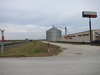
Burr, also known as Lawson's Corner or Kriegel Switch, is an unincorporated community in eastern Wharton County, in the U.S. state of Texas. The small community is situated on Farm to Market Road 1301 (FM 1301) to the east of the county seat at Wharton. The settlement was first established just before the Civil War, when two plantations were set up in the area. In the 1890s, it was a thriving community, but by the 1940s it had begun to dwindle. In 2013, a few businesses and several homes and farms were in the area.
Mackay is an unincorporated community in central Wharton County, in the U.S. state of Texas. The once thriving community is located on U.S. Route 59, (US 59) southwest of Wharton near Wharton Regional Airport. Mackay began as a railroad stop near a large ranch in 1881 and saw an influx of immigrants beginning in 1907. The community had its own post office from 1921 to 1937, but most of the buildings were gone by 1990. There were two businesses and a grain silo at the site in 2014.
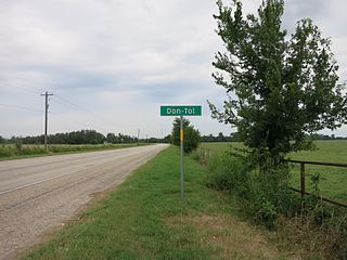
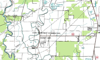
Don-Tol is a small unincorporated community in southeastern Wharton County, in the U.S. state of Texas. The community is located along FM 1301 southeast of Boling. There is a Don-Tol sign on FM 1301 at County Road 100. The name was used by Mexican workers to address William Toliver Taylor, the owner of a post-Civil War sugar cane plantation.
William Penn is an unincorporated community in Washington County, Texas, United States. According to the Handbook of Texas, the community had a population of 100 in 2000. It is located within the Greater Houston metropolitan area.