
Nahan is a town in Himachal Pradesh in India and is the headquarters of the Sirmaur District It was the capital of the former Sirmur princely state.Nahan is also known as the Town of ponds.
Nawalgarh is a heritage city in Jhunjhunu district of Indian state of Rajasthan. It is part of the Shekhawati region and is midway between Jhunjhunu and Sikar. It is 31.5 km from Sikar and 39.2 km from Jhunjhunu. Nawalgarh is famous for its fresco and havelis and considered as Golden City of Rajasthan. It is also the motherland of some great business families of India.
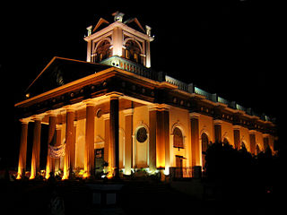
Kapurthala is a city in Punjab state of India. It is the administrative headquarters of Kapurthala District. It was the capital of the Kapurthala State, a princely state in British India. The aesthetic mix of the city with its prominent buildings based on French and Indo-Saracenic architecture self-narrate its princely past. It is also known as city of Palaces & Gardens. According to the 2011 census, Kapurthala is the least populated city in India.
Beawar is a city in Beawar district of Indian state of Rajasthan. As of 2011, the population of Beawar is 342,935. It is located 60 kilometres south from Ajmer, the divisional headquarter and 184 kilometres (114 mi) southwest of the state capital Jaipur, amidst Aravali hills. The city used to be a major center for trade, especially in raw cotton, and used to have cotton presses and the Krishna cotton mills. Currently, major industries include mineral-based units, machine-based units, machine tools and accessories, pre-stressed concrete pipes, plastic products, textiles, wooden furniture and asbestos cement pipes. Beawar is the largest producer of cement in northern India and home to Shree Cement. It is situated in a mineral-rich region having reserves of feldspar, quartz, asbestos, soapstone, magnesite, calcite, limestone, mica, emerald, granite, and masonry stone. Reserves of barytes, fluorite, wollastonite and vermiculite have also been found. Nearest airports are Jodhpur (145 km), Kishangarh and Jaipur (190 km). It is also connected by RSRTC operated buses to all parts of Rajasthan, and neighboring Delhi NCR, Ahmedabad (Gujarat), Gwalior. It also has railway connectivity with Delhi, Mumbai, Ahmadabad, Bangalore (bi-weekly), Haridwar, Dehradun (weekly), Bareilly and Muzzafarpur.

Takhatgarh is a town in Pali District of Rajasthan state in India. The town is one of the nine municipalities in the district, located near the district border. It is only about 160 years old.
Chamoli Gopeshwar is a township in the Garhwal hills and a municipal board within Chamoli district. It is the administrative headquarters of the Chamoli District of Uttarakhand in India. Located 1,550 m (5,090 ft) above sea level. It is famous for its weather which is pleasant most of the year but very cold in December and January. Chamoli Gopeshwar is known for his very beautiful temple, Gopinath that has a deffinate special feeling to it. Chamoli Gopeshwar has a very beautiful water storage facility (kund) called Vaitrani.

Keshoraipatan is a city located in the state of Rajasthan, India. The town is famous for the temple of Keshav Rai Ji Maharaj or Lord Vishnu which lies on banks of the Chambal River. The town is 20 km from the well known education hub of India, Kota. Mratunjaya Mahadev temple is another important shrine of the town. The temple is one of the oldest temples of Rajasthan. There is a very old Jain temple of lord munisuvrat in the city. Kalyanrai temple is old temple of Keshavraiji. Here is a Teela where coins and many ancient things are found. There is "pandav shala" also located here. It is said that in exile period Pandavs came here. Kartik Poornima, Bundi Utsav, Taijaji Ki Ghodi and Dhol Gyaras are some famous festivals in Keshoraipatan. Many devotees take a bath in the Chambal River during Kartik poornima.
Nawa is a city, tehsil headquarters, panchayat samiti, and a municipality in Didwana Kuchaman District in the Indian state of Rajasthan. It is the Biggest Salt Market of Rajasthan.
Reoti is a town and a nagar panchayat in Ballia district in the Indian state of Uttar Pradesh. Known for got freedom before 1947 As usual India had got freedom on 15 Aug 1947 but all across the India Reoti town got freedom in 1942.

Sardarshahar is a city located in the Churu district of Rajasthan, India. It is also the seat of the Rajasthan legislative assembly Sardarshahar Assembly constituency. Sardarshahar is the tehsil headquarter. and part of the Churu Lok Sabha constituency. Sardarshahar was established in 1838 at the place of "Alwana" village in Bikaner state. The city is named after Sardar Singh, The son of Bikaner Maharaja(Raja Ratan Singh). It is known for its grand Havelis (mansions) with frescoes, The only Clock Tower (GhantaGhar) in Asia which streets running under it in all four directions, Shri Ichha Puran Balaji Mandir, Acharya Shri Mahapragya Samadhi Sthal(ShantiPeeth), Gandhi Vidya Mandir and many more. It is famous for its Food, handicraft work, silver work, and woodwork. It is the birthplace of the Eleventh Acharya -Acharyashri Mahashramanji of the Shri Jain Terapanthi Sect.

Surada is a town and a Notified Area Council in Ganjam district in the Indian state of Odisha.
Tarbha is a Notified Area Council in Subarnapur district in the Indian state of Odisha.
Giddarbaha is a town and a municipal council in Muktsar district, in the Indian state of Punjab. It is 19 kilometres (12 mi) from the city of Malout, 30 kilometres (19 mi) from the city of Bathinda and 40 kilometres (25 mi) from the city of Muktsar. It lies on NH-7, which connects Fazilka (Punjab) to Mana (Uttarakhand) in India.
Degana is a town municipality and headquarter to Sub-Division and Tehsil located in Nagaur district of Rajasthan, India.
Faridpur is a town and a small Nagar Palika and tehsil in Bareilly district in the Indian state of Uttar Pradesh. Faridpur is known for zari work. It comes under 122 Legislative assembly. Current M.L.A. is Professor Shyam Bihari Lal and M.P. is Mr. Dharmendra Kashyap. Nagarpalika Chairman of Faridpur is Mr Sharaf Zari Wale
Bijainagar is a city and headquarters of Bijainagar tehsil in the Beawar district of the Indian state of Rajasthan.It was founded by Shri Rao Saheb Vijay Singh ji Of Masuda in 1919 CE,This city is situated along the Khari River close to the southern border of Ajmer District.
Ramnagar is a town and notified area committee in Udhampur District in the Indian union territory of Jammu and Kashmir.
Medi is a village in Wazirpur in Gangapur City District in the Indian state of Rajasthan.
Apra also known as The Golden City Apra is a census town in Phillaur Tehsil in Jalandhar district of Punjab State, India. The town is known for gold jewelry and paddy crops which are produced in large amounts. It is located 46 kilometres (29 mi) towards East from Jalandhar, 12 kilometres (7.5 mi) from Phillaur and 110 kilometres (68 mi) from Chandigarh. Apra is the largest town as compared to other surrounding villages and has the main marketplace. The town is administrated by Sarpanch an elected representative of the village.

