
The Chiricahua Mountains massif is a large mountain range in southeastern Arizona which is part of the Basin and Range province of the west and southwestern United States and northwest Mexico; the range is part of the Coronado National Forest. The highest point, Chiricahua Peak, rises 9,759 feet (2,975 m) above sea level, approximately 6,000 feet (1,800 m) above the surrounding valleys. The range takes its name from the Chiricahua Apaches native to the region.

Apache Pass, also known by its earlier Spanish name Puerto del Dado, is a historic mountain pass in the U.S. state of Arizona between the Dos Cabezas Mountains and Chiricahua Mountains at an elevation of 5,110 feet (1,560 m). It is approximately 20 miles (32 km) east-southeast of Willcox, Arizona, in Cochise County.

Texas Canyon is a valley in Cochise County, Arizona, about 20 miles east of Benson on Interstate 10. Lying between the Little Dragoon Mountains to the north and the Dragoon Mountains to the south and known for its giant granite boulders, the canyon attracts rockhounds and photographers.
The Boot Heel volcanic field is located in the Bootheel region of southwest New Mexico, adjacent areas of southeastern Arizona, and northwest Mexico. The field covers an area of more than 24,000 km2. The field includes nine volcanic calderas ranging in age from 26.9 to 35.3 Ma. Extrusive products include rhyolitic ignimbrites along with basalt, andesite, and rhyolite lava flows. The major ash flow tuff sheets produced, range in volume from 35 to 650 km3.

Doubtful Canyon was the name of two canyons in the Peloncillo Mountains, once considered in the 19th century as one canyon that served as the pass through those mountains.

The Peloncillo Mountains of Cochise County is a mountain range in northeast Cochise County, Arizona. A northern north-south stretch of the range extends to the southern region of Greenlee County on the northeast, and a southeast region of Graham County on the northwest. The north stretch of the Peloncillo's forms the border between the two counties. It lies east and northeast of the Willcox Playa, and the San Simon Valley.
The San Simon Valley is a broad valley east of the Chiricahua Mountains, in the northeast corner of Cochise County, Arizona and southeastern Graham County, with a small portion near Antelope Pass in Hidalgo County of southwestern New Mexico. The valley trends generally north–south but in its northern portion trends northwest–southeast. The San Simon Valley separates the Chiricahua Mountains, Dos Cabezas Mountains and Pinaleno Mountains on the west from the Peloncillo Mountains and the smaller Whitlock Mountains to the east.

The Peloncillo Mountains of Hidalgo County,, is a major 35-mile (56 km) long mountain range southwest of New Mexico's Hidalgo County, and also part of the New Mexico Bootheel region. The range continues to the northwest into Arizona as the Peloncillo Mountains of Cochise County, Arizona. The extreme southwest corner of the range also lies in Arizona. It is a linear range bordering the linear San Bernardino Valley of southeast Cochise County, Arizona.

San Simon is a census-designated place in Cochise County, Arizona, United States. As of the 2010 census, it had a population of 165. San Simon is located along Interstate 10, 40 miles (64 km) east of Willcox. The community has a ZIP code of 85632.
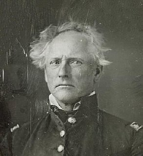
Enoch Steen was a United States military officer and western explorer. He joined the United States Army in 1832, serving at posts throughout the United States, including many remote locations in the west. During his military service, Steen explored parts of the western United States including large areas of southern New Mexico and southeastern Oregon. He served as the commander of several Union Army forts during the American Civil War. Today, there are landmarks in Oklahoma, Oregon, and New Mexico named in his honor; however, many of the place names are misspelled as Stein.

Steins Peak is a 5,864-foot-high (1,787 m) mountain in Hidalgo County, New Mexico. It lies south of the upper reach of Doubtful Canyon. It is located 0.3 miles (0.5 km) east of the Arizona, New Mexico State line and 8 miles (13 km) north northwest of Steins, New Mexico.

Buckskin Mountain is a 16-mile (26 km) mountain ridge that spans from Coconino County, Arizona to Kane County, Utah in the United States, that is divided almost equally between the two counties.
Stein's Peak Station, was one of the original stage stations of the Butterfield Overland Mail. Its ruins are still to be seen in Doubtful Canyon, at an elevation of 4652 feet, northeast of Stein's Peak in Hidalgo County, New Mexico. Stein's Peak Station, was 35 miles (56 km) east of Apache Pass Station and 42 miles (68 km) west of Soldier's Farewell Stage Station. Later stations were located midway between these stations to provide water and changes of horse teams in the hot, arid climate. These were San Simon Station to the west and Mexican Springs Station to the east of Lordsburg, New Mexico.
San Simon River is an ephemeral river, or stream running through the San Simon Valley in Graham and Cochise County, Arizona and Hidalgo County, New Mexico. Its mouth is at its confluence with the Gila River at Safford in Graham County. Its source is located at 31°51′21″N109°01′27″W.
Stein's Pass, is a gap or mountain pass through the Peloncillo Mountains of Hidalgo County, New Mexico. The pass was named after United States Army Major Enoch Steen, who camped nearby in 1856, as he explored the recently acquired Gadsden Purchase. The pass is in the form of a canyon cut through the mountains through which Steins Creek flows to the west just west of the apex of the pass to the canyon mouth at 32°13′19″N109°01′48″W.
Steins Creek, a stream or arroyo tributary to the San Simon River, that arises within an east–west running canyon, in Hidalgo County, New Mexico with its mouth in Cochise County, Arizona. This canyon provides the gap, called Stein's Pass, through which the railroad and Interstate 10 pass through the Peloncillo Mountains. Steins Creek has its source at 32°14′10″N108°59′43″W, and its mouth in the San Simon Valley, where its waters usually sink into the soil, short of any confluence with the San Simon River.
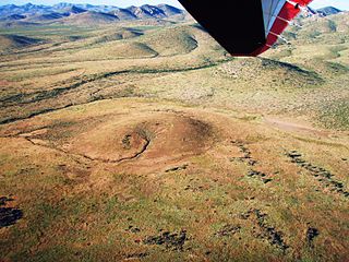
Cienega of San Simon, was a cienega, an area of springs 13 miles up the San Simon River from San Simon Station, in Cochise County, Arizona.

Apache Peak, at 7,714 feet (2,351 m), is the highest peak in the Whetstone Mountains in Cochise County, Arizona. The summit, located in the Coronado National Forest, is a popular local hiking destination. It is located near the Kartchner Caverns State Park, the city of Benson, Interstate 10, and Arizona State Route 90.
Whitmire Creek is a stream tributary to Animas Creek within Hidalgo County, New Mexico. Its source is in Whitmire Canyon in the Peloncillo Mountains in Cochise County, Arizona. It is one of two creeks of that name that are tributary to Animas Creek in the Animas Valley. They both were named for J. B. Whitmire one of the first settlers that established the Whitmire Ranch in the area during the 1880s.
