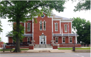
Washington County is a county located in the U.S. state of Illinois. According to the 2010 census, it had a population of 14,716. Its county seat is Nashville. It is located in the southern portion of Illinois known locally as "Little Egypt".
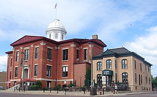
McHenry County is a county located in the U.S. state of Illinois. According to the 2010 census, it had a population of 308,760, making it the sixth-most populous county in Illinois. Its county seat is Woodstock.

Algonquin is a village in McHenry and Kane counties, Illinois, in the United States. It is a suburb of Chicago, located approximately 40 miles (64 km) northwest of the Loop. As of the 2010 census the village's population was 30,046, and as of 2017 the estimated population was 31,017.
Huntley is a village in McHenry and Kane counties, Illinois, United States. As of the 2010 census it had a population of 24,291, and as of 2017 the estimated population was 27,207. It is a part of the Chicago metropolitan area.

Southern Illinois is the southern third of the state of Illinois. The southern part of Illinois has a unique cultural and regional history. Part of downstate Illinois, the Southern Illinois region is bordered by the two most voluminous rivers in the United States: the Mississippi River and its connecting Missouri River to the west, and the Ohio River to the east and south with the Wabash as tributary.

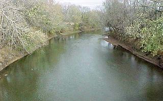
The Kaskaskia River is a tributary of the Mississippi River, approximately 325 miles (523 km) long, in central and southern Illinois in the United States. The second largest river system within Illinois, it drains a rural area of farms, as well as rolling hills along river bottoms of hardwood forests in its lower reaches. The lower reaches of the river have been canalized to allow barge traffic.

The Shawnee Hills is a region of southern Illinois that rests mainly in an east-west arc roughly following the outline of the southern end of the Illinois Basin. Whereas Mississippian and Pennsylvania Age rock layers are deep beneath the surface in central Illinois, these strata pierce the surface in southern Illinois. The Shawnee Hills are surface expressions of the more weather-resistant limestone and sandstone layers.
The Spoon River is a 147-mile-long (237 km) tributary of the Illinois River in west-central Illinois in the United States. The river drains largely agricultural prairie country between Peoria and Galesburg. The river is noted for giving its name to the fictional Illinois town in the 1916 poetry work Spoon River Anthology by Edgar Lee Masters, who was from Lewistown, which is near the river.
Illinois Route 173 is an east–west state road that runs from Illinois Route 251 in the Rockford suburb of Machesney Park east to Illinois Route 137 in Zion near the Illinois-Wisconsin border; this is a distance of 66.20 miles (106.54 km). Illinois Route 173 is also one of the northernmost east-west state highways in Illinois. On Interstate 94 traveling south from Wisconsin, it is the second road seen which has an interchange at that location. Similarly, when traveling south/east from Wisconsin on Interstate 39/90, Illinois Route 173 is only the third exit into Illinois. In 2008, the entirety of Illinois 173 has been designated the 173rd Airborne Brigade Highway
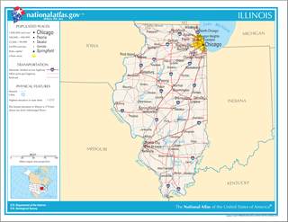
Illinois is in the midwestern United States. Surrounding states are Wisconsin to the north, Iowa and Missouri to the west, Kentucky to the south, and Indiana to the east. Illinois also borders Michigan, but only via a northeastern water boundary in Lake Michigan. Nearly the entire western boundary is the Mississippi River, except for a few areas where the river has changed course. Illinois' southeastern and southern boundary is along the Wabash River and the Ohio River. Whereas, its northern boundary and much of its eastern boundary are straight survey lines. Illinois has a maximum north-south distance of 390 miles and 210 miles east-west. Its total area is 57,918 square miles (150,010 km2).

Mossville is an unincorporated community between Peoria and Chillicothe in Peoria County, Illinois, United States. Mossville is part of the Peoria, Illinois Metropolitan Statistical Area and resides closely to the northern part of Peoria. Centered on the Illinois River valley and the end of Illinois Route 6 at Illinois Route 29, Mossville informally encompasses a number of different neighborhoods along the valley: Renchville, Brookview, a cluster of houses along the Illinois River referred to as "The Lanes", and Cedar Hills Estates, as well as the unincorporated village of 900 that can be considered Mossville proper. The Lake of the Woods subdivision, as well as Colony Point, both on the west bluff of the Illinois River valley overlooking Mossville, can also be considered to be part of the greater Mossville area. It was previously served by the Rock Island Line at Mossville Station.

New City is an unincorporated community in Cotton Hill Township, Sangamon County, Illinois, United States, in the rural center of the state. It is part of the Springfield, Illinois Metropolitan Statistical Area.
Illinois Route 93 is an east–west state road in central Illinois. It runs from Illinois Route 91, one mile (1.6 km) west of Elmira to Illinois Route 40, one mile (1.6 km) west of Bradford. This is a distance of 9.60 miles (15.45 km).
U.S. Route 30 (US 30) is an east–west arterial surface road in northern Illinois. It runs from across the Mississippi River from Clinton, Iowa, to Lynwood at the Indiana state line. This is a distance of 153.79 miles (247.50 km).

The 6th congressional district of Illinois covers parts of Cook, DuPage, Lake, Kane and McHenry counties, as of the 2011 redistricting which followed the 2010 census. All or parts of Algonquin, Barrington, Barrington Hills, Bartlett, Burr Ridge, Carol Stream, Carpentersville, Cary, Clarendon Hills, Crystal Lake, Darien, Deer Park, Downers Grove, Elgin, East Dundee, Forest Lake, Fox River Grove, Gilberts, Glen Ellyn, Hawthorn Woods, Hinsdale, Hoffman Estates, Inverness, Kildeer, Lake Barrington, Lake in the Hills, Lake Zurich, Lakewood, Lisle, Lombard, Long Grove, Naperville, North Barrington, Oak Brook, Oakbrook Terrace, Oakwood Hills, Palatine, Port Barrington, Rolling Meadows, Sleepy Hollow, South Barrington, South Elgin, St. Charles, Tower Lakes, Trout Valley, Warrenville, Wayne, West Chicago, West Dundee, Westmont, Wheaton, Willowbrook and Winfield are included.
Mount Carroll Township is one of twelve townships in Carroll County, Illinois, USA. As of the 2010 census, its population was 2,279 and it contained 1,101 housing units.

Flannigan Township is one of twelve townships in Hamilton County, Illinois, USA. As of the 2010 census, its population was 116 and it contained 74 housing units.
Riddle Hill is a rural unincorporated community located in Curran and Woodside townships, Sangamon County, Illinois. It is a crossroads located adjacent to where Old Jacksonville Road crosses Little Spring Creek, 6.5 miles west of Springfield.
Rural Hill is an unincorporated community in Hamilton County, Illinois, United States.


