Westcountry Rivers Trust

Last updated

An eyot in the River Camel between Polbrock and Pendavey looking upstream. River camel Feb2008.JPG
An eyot in the River Camel between Polbrock and Pendavey looking upstream.
River Looe River Looe.jpg
River Looe
River Fowey Lostwithiel bridge river Fowey Cornwall.jpg
River Fowey
River Otter River Otter Devon.jpg
River Otter
River Axe River Axe Devon.JPG
River Axe

The Westcountry Rivers Trust is a waterway society and a registered charity No. 1135007 in the West Country of England, United Kingdom. The Trust was founded in 1995 and aims to protect and enhance the West Country's rivers and streams, and to work with the region's landowners, farmers and the wider community, mainly through education projects.

Contents

History of the Trust

The Westcountry Rivers Trust was launched in 1994 by a group of individuals who shared a love of rivers and concerns for the health of freshwater environments in the region. These individuals were particularly motivated to act, having observed a decline in water quality and fish populations in the rivers Taw and Torridge, largely resulting from drought and eutrophication. Additionally, they had been inspired by the success of communities joining together elsewhere to improve their environment. This group went on to become the first board of trustees when the Westcountry Rivers Trust gained its charitable status in 1995 and included a number of notable figures: Poet Laureate Ted Hughes, Stuart Gardiner, Lord Clinton, Teddy Goldsmith, Nick Grant, Alan Hawken, Michael Heathcoat-Amory, Michael Martin, Bill Tucker and Ann Voss-Bark. After a long period of volunteering, the first employee of the Trust was Arlin Rickard, who set up headquarters in his home. Arlin Rickard has since become CEO of The Rivers Trust.

The approach to river restoration taken by the Westcountry Rivers was particularly innovative at the time since it encouraged people to see how efforts to restore rivers have multiple additional benefits to farmers, water companies, tourism, estuary dredging and human health. Consequently, the changes to practice encouraged by the Trust outlasted the length of the projects.

The Westcountry Rivers Trust offered a refreshing stance to the restoration of our rivers; while so many efforts to conserve the environment are limited to the length of the project, it realised that it could open people's eyes to the wider benefits of river restoration. Measures to protect rivers could also help to save money for farmers, lower costs for water companies, boost tourism, reduce the need to dredge our estuaries and even benefit human health. Further to this, the Trust ensured that their work took into account the best available science and adopted an ‘ecosystems approach,’ which considers the functioning of the entire river catchment, rather than focusing solely on the river channel.

Despite its beginning as a small, grassroots charity, the potential of the Westcountry Rivers Trust's approach to make positive change to the river environment was recognised in 1996 when it was awarded the £1.6 million Tamar 2000 project. In 2017, the Trust employs a team of 36 and its approach to river restoration has been rolled out nationwide; following the establishment of The Rivers Trust in 2001, there are now in excess of 54 rivers trusts across the UK, making the rivers trust movement one of the most rapidly growing environmental movements.

Projects

Upstream Thinking 2 (2015–2020)

Alongside partners from Devon Wildlife Trust, Cornwall Wildlife Trust & Exmoor National Park Authority, the Westcountry Rivers Trust is currently delivering the second phase of the South West Water-funded Upstream Thinking project.

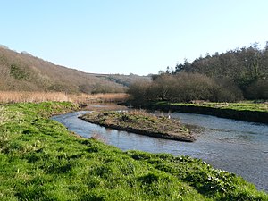
The main aim of the Upstream Thinking project is to improve the quality of water in our rivers, which are the primary source of drinking water in the South West, and so reduce the need for costly and resource-intensive treatment processes at the Water treatment works. Often water quality issues in the region are caused by thousands of small incidents throughout the catchment. While these individual incidents tend not to be severe enough to breach water standards, they can have a large cumulative effect on the river. The approach taken by the Westcountry Rivers Trust is to work with landowners to reduce or mitigate the pressures on the river system across 5 important river catchments in the Westcountry: the Fowey, Tamar, Exe, Dart and Otter. In addition to the benefits to South West Water and their customers, the Upstream Thinking projects brings benefits in terms of the general health of the rivers, their ecology, wider biodiversity and agricultural productivity.

Upstream Thinking 2010–2015

The Trust delivered South West Water's funded Upstream Thinking project, which is a collaborative conservation project on a catchment scale working to deliver a sustainable approach to land and water resource management. The project targeted strategic catchments in the Westcountry, which supply reservoirs and abstraction points, in a move to significantly improve raw water quality. By doing so, it reduced the cost of treatment plant and continual upgrading which has become necessary due to the increased sediment and/or nutrient loading in watercourses. The Upstream Thinking initiative is collectively worth over £9m and was the first project of its kind in the UK. The project value to WRT was £3.2m in the PR09 period, which entails farm advice and tailored farm plans to identify and tackle diffuse pollution from agriculture across five catchments.

Upstream Thinking Reverse Auction

As part of Upstream Thinking the Trust ran a reverse auction run on the river Fowey in conjunction with the University or East Anglia (funded by the DEFRA Economics Team). The auction distributed £360k against competitive bids submitted by farmers for capital works and management actions enshrined in a contract and 25-year covenant. Bids were evaluated in terms of environmental value for money using an advisor devised scoring matrix to score different interventions and then weight them against the intensity of farming operations and geographical location and the inherent risk of their land.

Catchment Restoration Fund – River Improvement Projects

The Trust delivered 5 CRF projects on the South Hams rivers, Dart & Teign, Exe & Axe, South Cornwall Rivers and on the Taw. The Taw River Improvement Project (TRIP – £1.8m) delivered Good Ecological Status for the Water Framework Directive on the river Taw. The predominant failures of these projects are addressing lack of fish and high phosphate levels. The projects included: – data assessment and surveying group that is apportioning sediment and phosphate using modelling programmes (SAGIS, SCIMAP, PSYCHIC, ECM, etc.) and novel tracing work; – fisheries work running walk over surveys and improving fish habitat and access; – agricultural work, linking with farmers to reduce sedimentation and phosphate loss; and – biodiversity work, delivering with landowners to use habitat to address WFD failures.

Catchment Based Approach

The Westcountry Rivers Trust has played host to several Catchment partnership but the longest is the Tamar Catchment Area Partnership, which consists of over 100 stakeholders representing over 30 organisations and groups. The initial pilot sought to address a failure in communication between the wants and needs of the stakeholders across a broad suite of ecosystem services, which historically has resulted in a multitude of sectorally focused management plans that at best do not articulate with, and at worse conflict against, each other. The Stakeholders formed six working groups that looked at water quality (both diffuse and point source), water quantity (both flooding and drought), carbon sequestration, habitats for wildlife and recreation/culture. Each group created a map(s) of the areas important in the provision of the service they were interested derived from a mutually agreed set of rules and assumptions. These maps where then combined to create a map of multifunctional areas that are important in the provision of several services. This allowed the wider partnership to understand the value of the catchment and where there were areas where complementary actions could lead to cost-benefit improvements.

Cornwall Rivers Project

This £2.6 million Project, from 2002 to 2006, was funded by the European Union (European Agriculture Guidance and Guarantee Fund) Objective 1 Programme and by the UK Government's Department of Environment, Food and Rural Affairs. It was aimed at those managing land in the catchments of these rivers and streams:

An End of Project leaflet was produced:

See also

Related Research Articles

<span class="mw-page-title-main">Polruan</span> Human settlement in England

Polruan is a coastal village in the parish of Lanteglos-by-Fowey in Cornwall, England, United Kingdom. It is bounded on three sides by water: to the north by Pont Creek, to the west by the River Fowey and to the south by the English Channel and neighbours village Bodinnick to the north, connected by a 4-mile walk along the hill tops. Polruan is very steep and well protected from the prevailing winds and Polruan Pool is a haven for small boats.

<span class="mw-page-title-main">Liskeard and Looe Union Canal</span> Former canal in Cornwall, United Kingdom

The Liskeard and Looe Union Canal was a broad canal between Liskeard and Looe in Cornwall, United Kingdom. It was almost 6 miles (9.7 km) long and had 24 locks, and it opened progressively from 1827. The engineer was Robert Coad.

<span class="mw-page-title-main">River Fowey</span> River in Cornwall, England

The River Fowey is a river in Cornwall, England, United Kingdom.

<span class="mw-page-title-main">River Tamar</span> River in southwest England

The Tamar is a river in south west England, that forms most of the border between Devon and Cornwall. A part of the Tamar Valley is a World Heritage Site due to its historic mining activities.

<span class="mw-page-title-main">River Camel</span> River in Cornwall, England

The River Camel is a river in Cornwall, England. It rises on the edge of Bodmin Moor and with its tributaries its catchment area covers much of North Cornwall. The river flows into the eastern Celtic Sea between Stepper Point and Pentire Point having covered about 30 miles, making it the second longest river wholly in Cornwall. The river is tidal upstream to Egloshayle and is popular for sailing, birdwatching and fishing. The name Camel comes from the Cornish language for 'the crooked one', a reference to its winding course. Historically the river was divided into three named stretches. Heyl was the name for the estuary up to Egloshayle, the River Allen was the stretch between Egloshayle and Trecarne, whilst the Camel was reserved for the stretch of river between its source and Trecarne.

<span class="mw-page-title-main">National Estuarine Research Reserve</span> Network of 30 protected areas in the US

The National Estuarine Research Reserve System is a network of 30 protected areas established by partnerships between the National Oceanic and Atmospheric Administration (NOAA) and coastal states. The reserves represent different biogeographic regions of the United States. The National Estuarine Research Reserve System protects more than 1.3 million acres of coastal and estuarine habitats for long-term research, water-quality monitoring, education, and coastal stewardship.

<span class="mw-page-title-main">Bassenthwaite Lake</span> Large lake in the United Kingdom

Bassenthwaite Lake is a body of water in the Lake District in North West England, near the town of Keswick. It has an area of 5.3 km2 (2.0 sq mi), making the fourth largest of the lakes in the region. The lake has a length of approximately 4 miles (6.4 km) long and maximum width of 0.75 miles (1 km), a maximum depth of 19 m (62 ft), and a surface elevation of 68 m (223 ft) above sea level. Its primary inflow and outflow is the River Derwent, which drains into the Irish Sea at Workington. The lake is in the unitary authority of Cumberland, and the ceremonial county of Cumbria.

<span class="mw-page-title-main">River Lynher</span> River in east Cornwall, England

<span class="mw-page-title-main">Looe Valley Line</span> Community railway in east Cornwall, England

The Looe Valley Line is an 8+34-mile (14 km) community railway from Liskeard to Looe in Cornwall, England, that follows the valley of the East Looe River for much of its course. It is operated by Great Western Railway.

<span class="mw-page-title-main">River Looe</span> River in south-east Cornwall, England

The River Looe is a river in south-east Cornwall, which flows into the English Channel at Looe. It has two main branches, the East Looe River and the West Looe River. The eastern branch has its source near St Cleer only 0.31 miles (0.5 km) away from the Golitha Falls on the River Fowey, and flows south, passing close to the western outskirts of Liskeard. The western branch has its source near Dobwalls.

<span class="mw-page-title-main">River Torridge</span> River in Devon, England

The River Torridge is a river in Devon in England; it rises near Meddon. The river describes a long loop through Devon farming country where its tributaries the Lew and Okement join before meeting the Taw at Appledore and flowing into the Bristol Channel. The river is spate dependent and often flows between wooded banks which can be steep. The Torridge local government district is named after the river.

<span class="mw-page-title-main">Gribben Head</span> Headland on the south coast of Cornwall, England

Gribbin Head is a promontory on the south coast of Cornwall, England, UK, owned and managed by the National Trust. It separates St Austell Bay from the estuary of the River Fowey and is marked by a large tower used to aid navigation of ships approaching the local harbours. The nearest town is Fowey. The western point of the headland is called Little Gribbin.

<span class="mw-page-title-main">Fishing in Cornwall</span> Economic activity

Fishing in Cornwall, England, UK, has traditionally been one of the main elements of the economy of the county. Pilchard fishing and processing was a thriving industry in Cornwall from around 1750 to around 1880, after which it went into an almost terminal decline. During the 20th century the varieties of fish taken became much more diverse and crustaceans such as crab and lobster are now significant. Much of the catch is exported to France due to the higher prices obtainable there. Though fishing has been significantly damaged by overfishing, the Southwest Handline Fishermen's Association has started to revive the fishing industry. As of 2007, stocks were improving. The Cornwall Sea Fisheries Committee is one of 12 committees responsible for managing the corresponding Sea Fisheries District. The Isles of Scilly Sea Fisheries Committee is responsible for the Scilly district.

<span class="mw-page-title-main">River Ottery</span> River in northeast Cornwall, England

The River Ottery is a small river in northeast Cornwall, United Kingdom. The river is about twenty miles (32 km) long from its source southeast of Otterham to its confluence with the River Tamar at Nether Bridge, two miles (3.2 km) northeast of Launceston.

The Yorkshire Dales Rivers Trust was formed in 2004 with a remit to improve, restore and conserve the rivers Swale, Ure, Wharfe and Nidd whose headwaters lie within the Yorkshire Dales National Park and the Nidderdale Area of Outstanding Natural Beauty. The trust is a member of the Association of Rivers Trusts which set up as a charity in 2001 to represent member trusts and assist them with conserving river catchments across England and Wales.

<span class="mw-page-title-main">Fisheries Research and Development Corporation</span> Australian government organisation

The Fisheries Research and Development Corporation (FRDC) is a statutory corporation that manages research and development investment by the Australian Government and the Australian fishing and aquaculture commercial, recreational and Indigenous sectors.

<span class="mw-page-title-main">Cornwall Area of Outstanding Natural Beauty</span> Designated coastal areas and a moorland in southwesternmost county of England

The Cornwall Area of Outstanding Natural Beauty covers 958 square kilometres (370 sq mi) in Cornwall, England, UK; that is, about 27% of the total area of the county. It comprises 12 separate areas, designated under the National Parks and Access to the Countryside Act 1949 for special landscape protection. Of the areas, eleven cover stretches of coastline; the twelfth is Bodmin Moor. The areas are together treated as a single Area of Outstanding Natural Beauty (AONB).

<span class="mw-page-title-main">North Devon's Biosphere Reserve</span> UNESCO biosphere reserve in North Devon, England

North Devon's Biosphere Reserve is a UNESCO biosphere reserve in North Devon. It covers 55 square miles (140 km2) and is centred on Braunton Burrows, the largest sand dune system (psammosere) in England. The boundaries of the reserve follow the edges of the conjoined catchment basin of the Rivers Taw and the Torridge and stretch out to sea to include the island of Lundy. The biosphere reserve is primarily lowland farmland, and includes many protected sites including 63 Sites of Special Scientific Interest which protect habitats such as culm grassland and broadleaved woodlands. The most populous settlements in its buffer area are Barnstaple, Bideford, Northam, Ilfracombe, and Okehampton.

The Freshwater Trust is a conservation non-profit based in Portland, Oregon. The mission of The Freshwater Trust is to preserve and restore freshwater ecosystems.

<span class="mw-page-title-main">Outline of Cornwall</span> Overview of and topical guide to Cornwall

The following outline is provided as an overview of and topical guide to Cornwall: Cornwall – ceremonial county and unitary authority area of England within the United Kingdom. Cornwall is a peninsula bordered to the north and west by the Celtic Sea, to the south by the English Channel, and to the east by the county of Devon, over the River Tamar. Cornwall is also a royal duchy of the United Kingdom. It has an estimated population of half a million and it has its own distinctive history and culture.

References