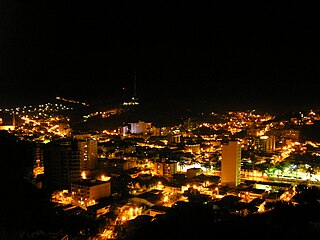
Ubá is a municipality located in the Zona da Mata mesoregion of Minas Gerais, Brazil, 290.88 kilometers (180.74 mi) southeast of Belo Horizonte, and 284.31 kilometers (176.66 mi) north of Rio de Janeiro. The estimated population of the city of Ubá was 116,797 in 2020. The current mayor of Ubá is Edson Teixeira Filho.

Roggenstede is an East Frisian village in Lower Saxony, Germany. It is an Ortsteil of the municipality of Dornum, in the district of Aurich. Roggenstede is located about 2 kilometers southeast of Dornum.

Hrádek is a municipality and village in Frýdek-Místek District in the Moravian-Silesian Region of the Czech Republic. It has about 1,900 inhabitants. The municipality has a significant Polish minority.

Baltrum is a barrier island off the coast of East Frisia, in Germany, and is a municipality in the district of Aurich, Lower Saxony. It is located in-between the chain of the seven inhabited East Frisian Islands. Baltrum is the smallest island in this chain by area and inhabitants. It has a land area of 6.5 square kilometres, and a population in (2011) of just over 500 resident inhabitants.
Dornum is a village and a municipality in the East Frisian district of Aurich, in Lower Saxony, Germany. It is located near the North Sea coast, approx. 15 km east of Norden, and 20 km north of Aurich.

Hönow is a village in Brandenburg, Germany, near the border of Berlin. Autonomous municipality until October 2003, it belongs to the municipality of Hoppegarten, in the district of Märkisch-Oderland; and its population is of 9,800 inhabitants.
Neßmersiel is an East Frisian village and seaside resort on the Wadden Sea coast in Lower Saxony, Germany. It is an Ortsteil of the municipality of Dornum, in the district of Aurich. Neßmersiel is located about 5 kilometers northwest of Dornum.

Ecseny is a village in Somogy county, Hungary.

Bollewick is a municipality in the Mecklenburgische Seenplatte district, in Mecklenburg-Vorpommern, Germany. It is administered by the Röbel-Müritz office in the city of Röbel / Müritz. The municipality Bollewick includes the villages Nätebow, Spitzkuhn and since 7 June 2009, Kambs and Wildkuhl.
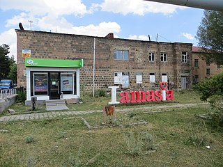
Amasia, previously known as Hamasia, is a village in the Amasia Municipality of the Shirak Province of Armenia. It is located on the right bank of the Akhuryan River.

Barisha is a village in northwestern Syria, administratively part of Harem District in the Idlib Governorate. In the 2004 Syrian census Barisha was listed with a population of 1,143. More recent reports place the population at about 7,000.

Nesse is an East Frisian village in Lower Saxony, Germany. It is an Ortsteil of the municipality of Dornum, in the district of Aurich. It is situated near the Wadden Sea coast, approximately 2.5 km west of the village of Dornum, and 20 km north of the town of Aurich. As of 2021, the village and surrounding farms had a population of 639.
Rudne is a rural settlement in Lviv Raion, Lviv Oblast, western Ukraine. It belongs to Lviv urban hromada, one of the hromadas of Ukraine. The population was 7,502.
Westermoordorf is a village (Ortsteil) of Großheide, a municipality in Lower Saxony, Germany. It is located about 1.5 kilometers northwest of the village of Berumerfehn.

Dornumergrode is an East Frisian village near the Wadden Sea coast in Lower Saxony, Germany. It is an Ortsteil of the municipality of Dornum, in the Aurich district.
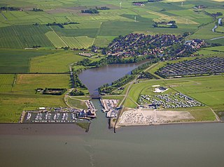
Dornumersiel is an East Frisian village and coastal resort on the Wadden Sea coast in Lower Saxony, Germany. It is an Ortsteil of the municipality of Dornum, in the Aurich district. The village is converged with the village core of Westeraccumersiel. The two settlements are only divided by Dornumersieler Tief, the historical border of Norderland and Harlingerland. Dornumersiel has been part of the municipality of Dornum since 2001.
Schwittersum is an East Frisian village in Lower Saxony, Germany. It is an Ortsteil of the municipality of Dornum, in the district of Aurich. Schwittersum is located directly to the southeast of Dornum, practically bordering its residential area.
Westdorf is an East Frisian village in Lower Saxony, Germany. It is an Ortsteil of the municipality of Dornum, in the district of Aurich. Administratively, the settlement of Ostdorf, located just to the east, belongs to the district of Westdorf.

Westeraccum is an East Frisian village in Lower Saxony, Germany. It is an Ortsteil of the municipality of Dornum, in the district of Aurich. The village is located just to the northeast of Dornum.

Münkeboe is an East Frisian village in Lower Saxony, Germany. It is an Ortsteil of the municipality of Südbrookmerland, in the district of Aurich. It is located southwest of the Ewiges Meer and approximately 8 kilometers northwest of Aurich.