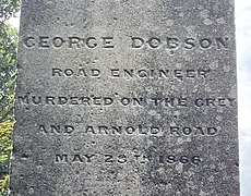
- George Dobson
Road Engineer
Murdered on the Grey
and Arnold Road
May 28th 1866
Westland Explorers' Monument | |
---|---|
Location | Hokitika Cemetery, New Zealand |
Coordinates | 42°42′32.4″S170°58′29.5″E / 42.709000°S 170.974861°E |
Built | 1868 |
Built for | Four early explorers who died on the West Coast |
Governing body | Westland District Council |
The Westland Explorers' Monument, also known as the Explorers' Monument, is an obelisk in Hokitika, New Zealand. It commemorates four men who lost their lives on the West Coast of the South Island between 1863 and 1866. The impetus for its erection in 1868 was the 1866 murder of George Dobson, and early on the monument was referred to as the Dobson Memorial. It was then referred to as the Weld Street Monument in reference to its original location in the centre of the intersection of Weld and Sewell streets. Deemed a traffic impediment, it was shifted to Hokitika Cemetery in 1880, but an even larger structure, the Hokitika Clock Tower, was put in its place at this intersection in 1902/1903.
A committee named the Dobson Memorial Fund formed in 1867 and suggested that a memorial be erected to commemorate four men. The committee members could not agree on the form of memorial, the materials to be used, or where to put it. George Sale, who had previously been provincial treasurer of Canterbury, was the committee's treasurer. He took charge and without liaising with fellow committee members, he ordered an obelisk from Sydney. [1] [2] The obelisk arrived with the Lizzie Coleson on 16 October 1867 and the first the public knew about the memorial was a notice in the West Coast Times on 24 October: [3] [4]
We understand that "The Dobson memorial", in the form of a very handsome monument, was landed the other day from the Lizzie Coleson. From this we infer that it was constructed in Sydney.
In the same edition of the newspaper, the previous day's municipal council proceedings were reported, including a request by Sale where the council would authorise the Dobson Memorial to be erected. [5] Sale's unilateral actions were initially condemned [6] but the mood soon swung and he received praise to have taken the initiative. It did not take long for the outstanding funds to be raised by public subscription. [1]
The memorial was placed in the centre of the intersection of Weld and Sewell streets; construction started on 29 February 1868. [7] [8] The contractor who won the construction tender was James Reynold. [9] Completion of the memorial was reported on 2 April 1868 but there was no opening ceremony; Hokitika was at the height of the Fenian Uprising at the time and the town was under martial law. [10] [11] The committee had run out of funds, though, and a rough hoarding was left around the monument, which attracted much negative comment. [12] The West Coast Times commented on 5 June 1868: [13]
The disgraceful state of the Dobson Memorial Monument is often the subject of public comment. Surrounded by a broken hoarding which is plastered with placards, whatever beauty there may be in this tribute to the memory of brave men, is entirely lost—even the inscription cannot be read. Surely some steps might be taken to remove the battered hoarding and replace it with a neat railing, if not of iron, at least of wood, so that the monument might be exposed to view, and not remain, as it is, a disgrace to those who erected it and the part of the town on which it stands.
A fundraising concert was organised by the Caxton Dramatic Club. [14] It took until March 1869 before tenders for a railing were called for by Westland County. [15] Before the railing was installed, unknown people pulled down the hoarding overnight on 3 April 1869. [16] Later that month, an iron railing was installed. [17]
On the grounds that it was "not an ornament" and an obstruction, [18] the Hokitika Borough Council resolved in May 1880 to have the memorial relocated from its original location to Hokitika Cemetery. [19] The relocation work was tendered in July 1880. [20] The West Coast Times commented on the monument in its location one more time at this point: "The diminutive monument, or rather the exaggerated milestone, which has for so many years embellished or disfigured—as the reader pleases—the appearance of Weld street, is to be removed to the cemetery." [21] There were plans in 1913 to relocated the memorial to Cass Square but nothing came of this. [1]
Despite obstruction being one of the reasons put forward for the relocation of the monument in 1880, and even larger monument constructed in 1902/1903 was built in its place. The Hokitika Clock Tower has a square base measuring 3.4 metres (11 ft) compared to the 2.4 metres (8 ft) of the Westland Explorers' Monument. [9] [22]
The quadrilateral memorial was made from Sydney freestone. The obelisk rests on a three-tiered base. Each tier is one foot high and they measure eight, six and four feet square. The obelisk measures 18 feet 6 inches (5.64 m) in height, which together with the base comes to 21 feet 6 inches (6.55 m). The column is made of three parts and the lowest part has inscriptions for four men to be commemorated, each face dedicated to one of them. [9]
Listed here in order of their deaths, four men are commemorated.
Henry Whitcombe (1830 – 6 May 1863) was a civil engineer and explorer employed by the Canterbury Provincial Council as an engineer and surveyor. [24] Whitcombe was exploring a possible route from Canterbury to the West Coast with Jacob Lauper. [25] When crossing the Taramakau River, their canoe was washed out to sea and Whitcombe drowned. [26] Lauper's diary was written in German and some details appeared inconsistent. A newer translation of his diary formed the basis of a book about the journey published in 2010: Pushing his Luck: Report of the expedition and death of Henry Whitcombe. [27]
Charlton Howitt (1838 – 27 June 1863) was a surveyor. He had a contract with the Canterbury Provincial Council to open up a track to the West Coast via Harper Pass. Howitt, together with two other members of his party, Robert Little and Henry Miller, drowned in Lake Brunner on 27 June 1863; their bodies were never found. [28] News of the party's death was first published in the Christchurch newspaper The Press on 4 September 1863. [29]
Charles Townsend (1826 – 9 October 1863) was a surveyor by trade. He was storekeeper in Greymouth on behalf of the Canterbury Provincial Council. Townsend and two of his men—Peter Michelmore and a Māori known as Solomon—drowned when their whaleboat capsized while crossing the Grey River bar. [30] [31]
George Dobson (26 June 1840 – 28 May 1866) was a surveyor and engineer. He was undertaking road construction in the Grey Valley and murdered in the Brunner Gorge by the Burgess Gang after being mistaken for a local gold buyer. [32]
Arthur's Pass is a mountain pass in the Southern Alps of the South Island of New Zealand. The pass sits 920 metres or 3,020 feet above sea level and marks part of the boundary between the West Coast and Canterbury regions. Located 140 km from Christchurch and 95 km from Greymouth, the pass comprises part of a saddle between the valleys of the Ōtira River and of the Bealey River. Arthur's Pass lies on the border of the Selwyn and Westland districts.
Hokitika is a town in the West Coast region of New Zealand's South Island, 40 kilometres (25 mi) south of Greymouth, and close to the mouth of the Hokitika River. It is the seat and largest town in the Westland District. The town's estimated population is 3,250 as of June 2024.
The Taramakau River is a river of the West Coast Region of the South Island of New Zealand. It rises in the Southern Alps / Kā Tiritiri o te Moana near Harper Pass, 80 kilometres (50 mi) due east of Hokitika, and runs westward for 75 kilometres (47 mi) into the Tasman Sea 15 kilometres (9.3 mi) south of Greymouth.
Westland South was a parliamentary electorate on the West Coast of New Zealand from 1868 to 1870.
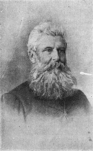
Charles Edward Button was a solicitor, Supreme Court judge, Mayor of Hokitika and later Birkenhead, and an independent conservative Member of Parliament in New Zealand. Born in Tasmania, he came to New Zealand with his wife in 1863. He first lived in Invercargill, then in Westland, and after a brief period in Christchurch, he settled in Auckland. He was an MP for two periods, and when he was first elected to Parliament, he beat his colleague, friend, political opponent, and later Premier Richard Seddon; this was the only election defeat ever suffered by Seddon.
Edmund Barff was a 19th-century Member of Parliament from the West Coast, New Zealand.
Gerard George Fitzgerald was a 19th-century Member of Parliament in New Zealand. Like his brother James FitzGerald, he was a journalist of considerable ability, and co-founded The Southland Times in 1862. For the last 19 years of his life, he was editor of The Timaru Herald.
Charles Edward Douglas was a New Zealand surveyor and explorer, who came to be known as Mr. Explorer Douglas, owing to his extensive explorations of the West Coast of New Zealand and his work for the New Zealand Survey Department. He was awarded the Royal Geographical Society Gill Memorial Prize in 1897.
The New Zealand Constitution Act 1852 authorised the General Assembly to establish new electoral districts and to alter the boundaries of, or abolish, existing districts whenever this was deemed necessary. The rapid growth of New Zealand's European population in the early years of representative government meant changes to electoral districts were implemented frequently, both at general elections, and on four occasions as supplementary elections within the lifetime of a parliament.
Westland High School, previously Hokitika High School or Hokitika District High School, is a secondary school in Hokitika, New Zealand.
The Westland Boroughs by-election 1868 was a by-election held in the Westland Boroughs electorate during the 4th New Zealand Parliament, on 3 April 1868.
The Mayor of Hokitika officiated over the borough of Hokitika in New Zealand. The office was created in 1866 when Hokitika became a municipality and a borough two years later, and ceased with the 1989 local government reforms, when Hokitika Borough and Westland County merged to form Westland District. The first Mayor of Hokitika was James Bonar.
Westland County, also known as County of Westland, was a local government area on the West Coast of New Zealand's South Island. It existed from 1868 to 1873, and then from 1876 until 1989. In its first incarnation, it constituted the government for the area that was split from the Canterbury Province, with the West Coast gold rush having given the impetus for that split. It had the same administrative powers as a provincial council, but the legislative power rested with Parliament in Wellington. The first Westland County was the predecessor to Westland Province.
The Hokitika Borough was the borough council covering the urban part of the town of Hokitika, New Zealand between 1867 and 1989, when Hokitika Borough and Westland County merged to form Westland District.
The Hokitika Clock Tower, initially called the Westland War Memorial and then the Coronation and War Memorial, is a prominent landmark in Hokitika, New Zealand. The memorial was initiated, fundraised for, and carried out by a committee, to commemorate the region's contribution to the Second Boer War; not just the four local men who had died but all 130 who had gone to war in South Africa. An additional purpose was to provide Hokitika with a town clock.
Hokitika Gorge and the surrounding Hokitika Gorge Scenic Reserve are a major tourist destination some 33 kilometres (21 mi) or 40 minutes drive inland from Hokitika, New Zealand. Since August 2020, a second suspension bridge over the Hokitika River at the gorge provides the opportunity for a round track.
The Westland District Library is the public library in Hokitika, on the West Coast of New Zealand. Beginning as the Hokitika Literary Society in 1866, it occupied a Carnegie library building from 1908 as the Hokitika Free Public Library, moving out in 1975.
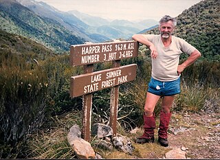
Harper Pass, previously known as Hurunui Pass or sometimes Taramakau Pass, is an alpine pass between Canterbury and the West Coast in New Zealand. It was the most important crossing for Māori to obtain pounamu. The first European crossed the pass in 1857 and the leader of the second party later that year, Leonard Harper, gave the pass its current name. It was of some interest to the settlers as the West Coast was part of Canterbury Province and it remained the only feasible route for some years. When the West Coast gold rush started in 1864, it became a heavily used crossing and remained so until October 1865, when a dray road over Arthur's Pass opened. The Arthur's Pass route was upgraded in March 1866 to coach traffic standard, and the much less direct route over Harper Pass fell out of use. It was restored in the 1930s as a tramping route and the Harper Pass Track, a four or five-day tramp, is today part of Te Araroa over its entire length.
Hokitika Cemetery, also known as Seaview Cemetery, is the cemetery for Hokitika in New Zealand.
George Dobson was a New Zealand surveyor and engineer who was murdered in the Brunner Gorge on the West Coast by the Burgess Gang after being mistaken for a local gold buyer.