The National Road was the first major improved highway in the United States built by the federal government. Built between 1811 and 1837, the 620-mile (1,000 km) road connected the Potomac and Ohio Rivers and was a main transport path to the West for thousands of settlers. When improved in the 1830s, it became the second U.S. road surfaced with the macadam process pioneered by Scotsman John Loudon McAdam.
Interstate 79 (I-79) is an Interstate Highway in the eastern United States, designated from I-77 in Charleston, West Virginia north to Pennsylvania Route 5 (PA 5) and PA 290 in Erie, Pennsylvania. It is a primary thoroughfare through western Pennsylvania and West Virginia, and makes up part of an important corridor to Buffalo, New York, and the border with Canada. Major metropolitan areas connected by I-79 include Charleston and Morgantown in West Virginia, and Pittsburgh, and Erie in Pennsylvania.
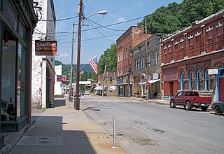
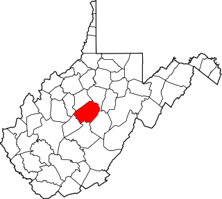
Sutton is a town in Braxton County, West Virginia, United States. The population was 994 at the 2010 census. It is the county seat of Braxton County. Sutton is situated at a center of transportation in West Virginia. Interstate 79, a major north–south route, connects with Appalachian Corridor L, another significant north–south route, passes several miles south of town.

Ansted is a town in Fayette County in the U.S. state of West Virginia. The population was 1,404 at the 2010 census. It is situated on high bluffs along U.S. Route 60 on a portion of the Midland Trail a National Scenic Byway near Hawks Nest overlooking the New River far below.
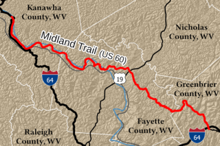
The Midland Trail is a National Scenic Byway which carries U.S. Route 60 (US 60) through a portion of the southern part of the U.S. state of West Virginia between Charleston and Sam Black Church. It was part of the longer transcontinental Midland Trail.

State Route 244 is a primary state highway in the U.S. state of Virginia. Known as Columbia Pike, the state highway runs 8.25 miles (13.28 km) from SR 236 in Annandale east to SR 27 and Interstate 395 (I-395) at The Pentagon in Arlington. SR 244 is a major southwest–northeast thoroughfare in northeastern Fairfax County and eastern Arlington County, connecting Annandale with SR 7 at Bailey's Crossroads and SR 120 in the multicultural Westmont neighborhood of Arlington.

The Gauley River is a 105-mile-long (169 km) river in West Virginia. It merges with the New River to form the Kanawha River, a tributary of the Ohio River. The river features numerous recreational whitewater areas, including those in Gauley River National Recreation Area downstream of the Summersville Dam.

Heaters is an unincorporated community in Braxton County, West Virginia, United States. Heaters is situated approximately three miles north of Flatwoods on U.S. Route 19, which is a paved two-lane road. Access from I-79 is at exit 67 in Flatwoods, or exit 79 at Burnsville, then Route 5 to Heaters. There is no stoplight in Heaters. Heaters has a United States Postal Service post office and the ZIP Code is 26627.

Johnson Newlon Camden was a prominent oilman, industrialist, banker, railroad tycoon, and politician who was estimated to have $25 million at the time of his unexpected death. Although both of his attempts to become governor of the new state of West Virginia failed, he did become United States Senator, representing West Virginia on two occasions.

Lemuel Chenoweth was a carpenter, legislator and self-taught architect. He is best known as one of 19th century America's master covered bridge builders.

Sutton Lake is a 1,520-acre (6 km2) reservoir on the Elk River in Braxton and Webster counties, West Virginia. Sutton Lake is located just upstream of Sutton. It was authorized by Congress in the Flood Control Act of 1938. Construction of the dam began in 1956 and was completed in 1961. The dam is 210 feet (64 m) high, 1,178 feet (359 m) long, and constructed of concrete. The lake was named by Congressional action, Public Law 90-46, July 4, 1967.
The Louisville and Nashville Turnpike was a toll road that ran from Louisville, Kentucky to Nashville, Tennessee during the 19th century. From Louisville, one route now designated US 31W ran through Elizabethtown, Munfordville, Glasgow Junction, Bowling Green, and Franklin before crossing into Tennessee. In Tennessee, the route would continue through Portland, Cross Plains, Millersville and Goodlettsville before going into Nashville. The other route ran through Bardstown, Buffalo, Glasgow, and Scottsville and is currently named US 31E. The name survives in abbreviated form along routes including Kentucky State Routes 335 and 470. US 31W is usually named for the Dixie Highway which succeeded the Turnpike.

Arlington Boulevard is a major arterial road in Arlington County, Fairfax County, and the independent City of Fairfax in Northern Virginia in metropolitan Washington, DC, United States. It is designated U.S. Route 50 (US 50) for its entire length and is part of the National Highway System.

The Washington–Rochambeau Revolutionary Route is a 680-mile (1,090 km) series of roads used in 1781 by the Continental Army under the command of George Washington and the Expédition Particulière under the command of Jean-Baptiste de Rochambeau during their 14-week march from Newport, Rhode Island, to Yorktown, Virginia. 4,000 French and 3,000 American soldiers began the march.
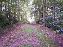
Bulltown is an extinct town in Braxton County, West Virginia, United States. The GNIS classifies it as a populated place.

U.S. Route 64 is a U.S. highway running from Teec Nos Pos, Arizona east to Nags Head, North Carolina. In the U.S. state of Arkansas, the route runs 246.35 miles (396.46 km) from the Oklahoma border in Fort Smith east to the Tennessee border in Memphis. The route passes through several cities and towns, including Fort Smith, Clarksville, Russellville, Conway, Searcy, and West Memphis. US 64 runs parallel to Interstate 40 until Conway, when I-40 takes a more southerly route.
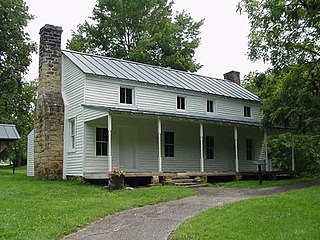
Cunningham House and Outbuildings, also known as Cunningham Farm, is a historic home located near Napier, Braxton County, West Virginia. The house dates to the 1830s, and is a two-story, log structure sided with white clapboards. Also located on the property is a food cellar and granary. The buildings are representative of traditional central West Virginia subsistence farming techniques. The site was purchased by the Army Corps of Engineers during the development of Burnsville Lake, and is administered as part of the Bulltown Historic Area.
Union Civil War Fortification, also known as Bulltown Civil War Site, is a historic archaeological site located near Napier, Braxton County, West Virginia. The site relates to the American Civil War Battle of Bulltown, that took place on October 13, 1863. During test excavations in the 1970s, remnants of structures, features, and artifacts were recovered. The site was purchased by the Army Corps of Engineers during the development of Burnsville Lake, and is administered as part of the Bulltown Historic Area.
This is a list of the National Register of Historic Places listings in Braxton County, West Virginia.