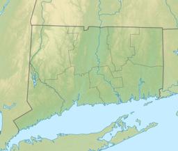
Hartford County is a county located in the north central part of the U.S. state of Connecticut. According to the 2020 census, the population was 899,498, making it the second-most populous county in Connecticut. Hartford County contains the city of Hartford, the state capital of Connecticut and the county's most populous city, with 121,054 residents at the 2020 census. Hartford County is included in the Hartford-East Hartford-Middletown metropolitan statistical area.

Glastonbury is a town in Hartford County, Connecticut, United States, formally founded in 1693 and first settled in 1636. The town was named after Glastonbury in Somerset, England. Glastonbury is located on the banks of the Connecticut River, 7 miles (11 km) southeast of Hartford. The town center is defined by the U.S. Census Bureau as a census-designated place (CDP). The population was 35,159 at the 2020 census.

Manchester is a town in Hartford County, Connecticut, United States. As of the 2020 census, the town had a total population of 59,713. The urban center of the town is the Manchester census-designated place, with a population of 36,379 at the 2020 census. The town is named after Manchester, in England.

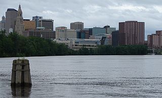
The Connecticut River is the longest river in the New England region of the United States, flowing roughly southward for 406 miles (653 km) through four states. It rises at the U.S. border with Quebec, Canada, and discharges at Long Island Sound. Its watershed encompasses 11,260 square miles (29,200 km2), covering parts of five U.S. states and one Canadian province, via 148 tributaries, 38 of which are major rivers. It produces 70% of Long Island Sound's fresh water, discharging at 18,400 cubic feet (520 m3) per second.

East Hartford is a town in Hartford County, Connecticut, United States. The population was 51,045 at the 2020 census. The town is located on the east bank of the Connecticut River, directly across from Hartford, Connecticut. It is home to aerospace manufacturer Pratt & Whitney. It is also home to Pratt & Whitney Stadium at Rentschler Field, a stadium used mainly for soccer and football with a capacity of 40,000 people.
Newington is a town in Hartford County, Connecticut, United States. Located 8 miles (13 km) south of downtown Hartford, Newington is an older, mainly residential suburb located in Greater Hartford. As of the 2020 census, the population was 30,536. The Connecticut Department of Transportation has its headquarters in Newington.

The Farmington River is a river, 46.7 miles (75.2 km) in length along its main stem, located in northwest Connecticut with major tributaries extending into southwest Massachusetts. The longest route of the river, from the origin of its West Branch, is 80.4 miles (129.4 km) long, making it the Connecticut River's longest tributary by 2.3 miles (3.7 km) over the major river directly to its north, the Westfield River. The Farmington River's watershed covers 609 square miles (1,580 km2). Historically, the river played an important role in small-scale manufacturing in towns along its course, but it is now mainly used for recreation and drinking water.
Greater Hartford is a region located in the U.S. state of Connecticut, centered on the state's capital of Hartford. It represents the only combined statistical area in Connecticut defined by a city within the state, being bordered by the Greater Boston region to the northeast and New York metropolitan area to the south and west. Sitting at the southern end of the Metacomet Ridge, its geology is characterized by land of a level grade along the shores of Connecticut River Valley, with finer-grained soil than other regions in the state.
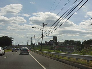
Interstate 84 (I-84) is an Interstate Highway in the northeastern United States that extends from Dunmore, Pennsylvania, at an interchange with I-81 east to Sturbridge, Massachusetts, at an interchange with the Massachusetts Turnpike (I-90). Among the major cities that the road passes through is Hartford, Connecticut. Another highway named I-84 is located in the northwestern United States.

The terms podunk and Podunk Hollow in American English denote or describe an insignificant, out-of-the-way, or even completely fictitious town. These terms are often used in the upper case as a placeholder name, to indicate "insignificance" and "lack of importance".
U.S. Route 6 (US 6) within the state of Connecticut runs for 116.33 miles (187.21 km) from the New York state line near Danbury to the Rhode Island state line in Killingly. West of Hartford, the route either closely parallels or runs along Interstate 84 (I-84), which has largely supplanted US 6 as a through route in western Connecticut. East of Hartford, US 6 serves as a primary route for travel between Hartford and Providence.

Connecticut's 1st congressional district is a congressional district in the U.S. state of Connecticut. Located in the north-central part of the state, the district is anchored by the state capital of Hartford. It encompasses much of central Connecticut and includes towns within Hartford, Litchfield, and Middlesex counties. With a PVI of D+11, it is the most Democratic district in Connecticut.

The McLean Game Refuge is a 4,400 acres (1,800 ha) nature preserve with the overwhelming majority of the land being in the town of Granby, with smaller tracts of land on the Granby border in Simsbury and Canton, Connecticut. Senator and Governor of Connecticut, George P. McLean had purchased the land throughout his life. It was left to the McLean Fund upon his death in 1932 and remains open to the public today. In November 1973, 1,800 acres (730 ha) of the Refuge were designated a National Natural Landmark.

Basset Brook is a stream formed at a shallow pond located approximately 1.4 miles northwest of Warrenville, Connecticut, United States,. The brook flows south and east from this pond and eventually to its mouth at the Mount Hope River, with a length of approximately 1.4 miles.

Beaver Brook State Park is an undeveloped public recreation area covering 401 acres (162 ha) in the towns of Windham and Chaplin, Connecticut. The state park encompasses Bibbins Pond, also known as Beaver Brook Pond, as well as the acreage northward as far as the Air Line State Park Trail, which forms the park's northern boundary. The park is a walk-in facility, open for hunting and trout fishing, managed by the Connecticut Department of Energy and Environmental Protection.
Quinebaug Lake State Park is a public recreation area covering 181 acres (73 ha) in the town of Killingly, Connecticut. The state park offers opportunities for fishing and non-motorized boating on Wauregan Reservoir. The park is managed by the Connecticut Department of Energy and Environmental Protection.

Sunnybrook State Park is a public recreation area encompassing 464 acres (188 ha) in the town of Torrington, Connecticut. The state park is the southwestern terminus for the blue-blazed John Muir Trail which crosses Paugnut State Forest for two miles to the loop trail at Burr Pond State Park. Another park trail bears the name of former property owner Edwin Fadoir. In addition to hiking, the park offers picnicking, hunting, and fishing along the East Branch Naugatuck River. The park opened in 1970 and entered the state rolls in the 1971 edition of the Connecticut Register and Manual.

The Pequabuck River is a river, approximately 19 miles (30.6 km) in length, which rises in Litchfield County, Connecticut, and courses through neighboring Hartford County before emptying into the Farmington River in Farmington. The river has played a crucial role in the development of Plainville, Connecticut, in particular. The river's lower drainage basin consists of industrial and urban areas, and effluents from these areas pollute the river's waters. The Pequabuck drove a water wheel that provided 8 horsepower to the Upper Lock Shop in Plymouth, Connecticut, a facility which would eventually become the Lewis Lock Company in 1851 and, finally, the once-renowned Eagle Lock Company. The river banks were historically the site of one of United States' first malleable iron-producing units, known as Malleable Iron Works.
Tuxis Pond, occasionally spelled Tunxis, is a small pond located in the town of Madison in New Haven County, Connecticut. The pond is 3.58 acres (1.45 ha) in area. Three small streams run into it, and one runs out to sea. Tuxis Pond is about three feet (0.9 m) above sea level. The shores are mostly rocky with little sand or soil. Many nearby businesses have taken the name of the pond, including a lumber company, bookseller, grill, highway, golf club, art show, and assisted living facility.