Wettringen (Münsterland)

Last updated
Wettringen
DE Wettringen COA.svg
Coat of arms
Location of Wettringen within Steinfurt district
Wettringen in ST.svgLengerichWettringenNeuenkirchenLotte
Germany adm location map.svg
Red pog.svg
Wettringen
North Rhine-Westphalia location map 01.svg
Red pog.svg
Wettringen
Coordinates: 52°12′30″N7°19′00″E / 52.20833°N 7.31667°E / 52.20833; 7.31667 Coordinates: 52°12′30″N7°19′00″E / 52.20833°N 7.31667°E / 52.20833; 7.31667
Country Germany
State North Rhine-Westphalia
Admin. region Münster
District Steinfurt
Government
   Mayor (202025) Berthold Bültgerds [1] (CDU)
Area
  Total57.2 km2 (22.1 sq mi)
Elevation
49 m (161 ft)
Population
 (2020-12-31) [2]
  Total8,271
  Density140/km2 (370/sq mi)
Time zone UTC+01:00 (CET)
  Summer (DST) UTC+02:00 (CEST)
Postal codes
48493
Dialling codes 02557
Vehicle registration ST
Website www.wettringen.de

Wettringen is a village and a municipality in the district of Steinfurt, in North Rhine-Westphalia, Germany.

Contents

Geography

Wettringen is situated on the river Steinfurter Aa. It is located in the region Münsterland, approx. 40 km north of Münster and approx. 25 km east to the Dutch border.

Division of the town

Wettringen consists of multiple smaller districts:

  • Wettringen
  • Aabauerschaft
  • Andorf
  • Bilk
  • Brechte
  • Dorfbauerschaft
  • Haddorf
  • Klein Haddorf
  • Maxhafen
  • Rothenberge
  • Tie-Esch
  • Vollenbrok

History

Wettringen was first mentioned in 838. A historical document says that in 838 Kaiser Louis the Pious donated the church of "Wateringas" to the nun monastery of Herford. This romanesque church was founded in 800 by Charlemagne. It was reconstructed in 1522.

In 1590, during the Dutch Revolt, Spanish Troops plundered Wettringen multiple times. In 1622, during the Thirty Years' War Wettringen was the victim of plunder and pillage again.

Churchtower (Pfarrkirche Sankt Petronilla) in the street Wettringen, toren van die Pfarrkirche Sankt Petronilla in straatzicht foto4 2013-09-28 11.50.jpg
Churchtower (Pfarrkirche Sankt Petronilla) in the street

In 1771 the "Münster Canal" was extended from its former end Clemenshafen in Neuenkirchen to its new end in Maxhafen. It was renamed to "Max-Clemens Canal" after the prince-bishops Maximilian Frederick of Königsegg-Rothenfels and Clemens August of Bavaria. The original plan was a connection between Münster and the Dutch Town of Zwolle, but the last segment was never completed. In 1840 shipping on the canal was given up due to being uneconomic.

In 1861 the old church was torn down and the diocese architect of Münster, Emil von Manger from Oelde, started to build a new gothic revival church. It was completed in 1863 and was consecrated to Saint Petronilla. This church still stands today in the village centre.

The Second World War also left its marks on Wettringen. On March 31, 1945, allied troops came to Wettringen. At the end of the year, approx. 1200 fugitives, predominantly from Silesia, found shelter in the village. In memory of the victims of the World War I and II a memorial was built in 1957 and it was complemented by a stele in 1998 to remind especially to the victims of the Holocaust. An old memorial from 1929 had to be removed due to traffic planning.

Coat of Arms

The coat of arms of Wettringen is colored in silver, red and gold, the traditional colors of the Münsterland. At the top is a silver bar with a curved red line in the middle. It is the symbol of the Edelherren of Wettringen. Below that is the red bar taken from the coat of arms of the nun monastery of Herford. At the bottom a swan is shown. This symbol is taken from the coat of arms of the Fürst of Bentheim-Steinfurt.

Main Sights

Buildings

Politics

Town council

The town council of Wettringen after the election of May 2014 is split-up as follows:

Mayors

Twin towns

Wettringen's twin towns are Fretin (France), the Dutch village Dalen and the German village Gnoien.

Related Research Articles

Steinfurt is a Kreis (district) in the northern part of North Rhine-Westphalia, Germany. Neighboring districts are Bentheim, Emsland, district-free Osnabrück and the Osnabrück district, Warendorf, district-free Münster, Coesfeld, Borken.

Rheine Place in North Rhine-Westphalia, Germany

Rheine is a city in the district of Steinfurt in Westphalia, Germany. It is the largest city in the district and the location of Rheine Air Base.

Borken is a Kreis (district) in the northwestern part of North Rhine-Westphalia, Germany in the Münster region. Neighboring districts are Steinfurt, Coesfeld, Recklinghausen, Wesel, Cleves, Bentheim in the Lower Saxony and the Dutch provinces Gelderland and Overijssel. The two biggest cities are Bocholt and Gronau.

Coesfeld (district) District in North Rhine-Westphalia, Germany

Coesfeld is a Kreis (district) in the northwestern part of North Rhine-Westphalia, Germany, west of the city of Münster. Neighboring districts are Steinfurt, district-free Münster, Warendorf, district-free Hamm, Unna, Recklinghausen, Borken.

Münster (region) Regierungsbezirk in North Rhine-Westphalia, Germany

Münster is one of the five Regierungsbezirke of North Rhine-Westphalia, Germany, located in the north of the state, and named after the capital city of Münster. It includes the area which in medieval times was known as the Dreingau.

Metelen Place in North Rhine-Westphalia, Germany

Metelen is a municipality in North Rhine-Westphalia, Germany. It is located on the river Vechte in the district of Steinfurt. Metelen Land station is located on the Münster–Enschede railway and has an hourly train service to Münster in one direction and to Enschede in the other direction.

Horstmar Place in North Rhine-Westphalia, Germany

Horstmar is a German town, located in North Rhine-Westphalia in the Steinfurt district, approx. 25 km (16 mi) north-west of Münster.

Laer Place in North Rhine-Westphalia, Germany

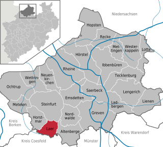
Laer is a municipality in the district of Steinfurt, in North Rhine-Westphalia, Germany. It is situated approximately 10 kilometres (6.2 mi) south of Steinfurt and 20 kilometres (12 mi) north-west of Münster.

Nottuln Place in North Rhine-Westphalia, Germany

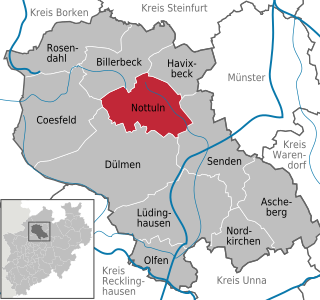
Nottuln is a municipality in the district of Coesfeld in the state of North Rhine-Westphalia, Germany.

Greven Place in North Rhine-Westphalia, Germany

Greven is a medium-sized town in the district of Steinfurt, in Germany's most populous state of North Rhine-Westphalia and close to the city of Münster.

Havixbeck Place in North Rhine-Westphalia, Germany

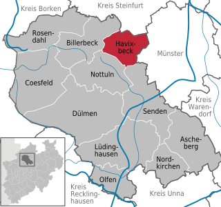
Havixbeck is a municipality situated on the north-east edge of the Baumberge in the district of Coesfeld, in northern North Rhine-Westphalia, Germany. It is located approximately 15 km west of Münster.

Senden, North Rhine-Westphalia Place in North Rhine-Westphalia, Germany

Senden is a municipality in the district of Coesfeld, in North Rhine-Westphalia, Germany.

Emsdetten Place in North Rhine-Westphalia, Germany

Emsdetten is a town in the district of Steinfurt, in North Rhine-Westphalia, Germany.

Hörstel Place in North Rhine-Westphalia, Germany

Hörstel  is a town in the district of Steinfurt, in North Rhine-Westphalia, Germany. It is situated near the junction of the Mittellandkanal and the Dortmund-Ems Canal, approx. 10 km east of Rheine.

Ibbenbüren Place in North Rhine-Westphalia, Germany

Ibbenbüren is a medium-sized town in the district of Steinfurt, in North Rhine-Westphalia, Germany.

Lengerich, Westphalia Place in North Rhine-Westphalia, Germany

Lengerich is a town in the district of Steinfurt, in North Rhine-Westphalia, Germany. It is situated on the southern slope of the Teutoburg Forest, approx. 15 km south-west of Osnabrück and 30 km north-east of Münster.

Ochtrup Town in Germany

Ochtrup is a town in the district of Steinfurt, in North Rhine-Westphalia, Germany. It is situated approximately 20 km west of Rheine and 20 km east of Enschede.

Ladbergen Place in North Rhine-Westphalia, Germany

Ladbergen is a municipality in the district of Steinfurt, in North Rhine-Westphalia, Germany. It is situated near the Dortmund-Ems Canal, approximately 25 km south-west of Osnabrück and 20 km north-east of Münster.

Neuenkirchen, Westphalia Place in North Rhine-Westphalia, Germany

Neuenkirchen is a municipality in the district of Steinfurt, in North Rhine-Westphalia, Germany. Neuenkirchen is the biggest village in the district of Steinfurt. It is situated approximately 7 km south-west of Rheine and 35 km north-west of Münster.

Nordwalde Place in North Rhine-Westphalia, Germany

Nordwalde is a municipality in the district of Steinfurt, in North Rhine-Westphalia, Germany.

References

  1. Wahlergebnisse in NRW Kommunalwahlen 2020, Land Nordrhein-Westfalen, accessed 30 June 2021.
  2. "Bevölkerung der Gemeinden Nordrhein-Westfalens am 31. Dezember 2020" (in German). Landesbetrieb Information und Technik NRW . Retrieved 21 June 2021.