Whauphill

Last updated

Whauphill
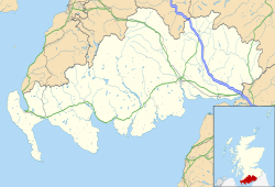
Dumfries and Galloway UK location map.svg
Red pog.svg
Whauphill
Location within Dumfries and Galloway
Council area
Lieutenancy area
Country Scotland
Sovereign state United Kingdom
Post town NEWTON STEWART
Postcode district DG8
Dialling code 01988
Police Scotland
Fire Scottish
Ambulance Scottish
UK Parliament
Scottish Parliament
List of places
UK
Scotland
54°48′00″N4°29′00″W / 54.800°N 4.4833°W / 54.800; -4.4833 Coordinates: 54°48′00″N4°29′00″W / 54.800°N 4.4833°W / 54.800; -4.4833

Whauphill is a small village located in the historical county of Wigtownshire in the Machars, Dumfries and Galloway, Scotland. [1]

Whauphill is a hub that supports the local industry, predominantly farming and agriculture. There are two tractor shops: Davidson Tractors, a family run Massey Ferguson Dealership, and a branch of Gordon's Agricultural Engineers. There is a branch of Tarff, a country shop, and feed merchant. There is also a post office, and a village hall.

Whauphill used to have a railway station, village shop, hotel and pub, but the advent of the motor car, and Lord Beecham put paid to the Railway Station, and the village shop quickly followed suit. The hotel was closed when the publican died of cancer. Recent drink driving laws and increase in alcohol taxation have caused revenues in the pub to fall to the point where it is no longer viable and it has closed. Council cuts were going to cause the Village Hall to close but in an end to long-term decline in Whauphill, a community group has now taken control of the village hall from the council and are using it successfully to run local community events.

Vans Agnew was elected as the Member of Parliament (MP) for Wigtownshire at a by-election in 1873.

Barnbarroch House, the ancestral seat of the Vans Agnew family, was a Classical house built in 1780, with later additions and remodelling by John Claudius Loudon in 1806. The House is now a shell having been burnt in 1942, killing Mrs Vans Agnew. [2]
Related Research Articles

Stranraer Town and sea port in Scotland

Stranraer, also known as The Toon, is a town in Dumfries and Galloway, Scotland. It is located in the historical parish of Inch in the historic county of Wigtownshire. It lies on the shores of Loch Ryan, on the northern side of the isthmus joining the Rhins of Galloway to the mainland. Stranraer is Dumfries and Galloway's second-largest town, with a population including the immediate surrounding area of nearly 13,000 inhabitants.

Cults, Aberdeen Human settlement in Scotland

Cults is a suburb on the western edge of Aberdeen, Scotland. It lies on the banks of the River Dee and marks the eastern boundary of Royal Deeside.

New Ferry Urban area in Merseyside, England

New Ferry is an urban area on the Metropolitan Borough of Wirral, Merseyside, England. It is located on the Wirral Peninsula, with the River Mersey to the east and the town of Bebington to the west. Within the boundaries of the historic county of Cheshire, the area was developed from the early nineteenth century.

Cruden Bay Human settlement in Scotland

Cruden Bay is a small village in Scotland, on the north coast of the Bay of Cruden in Aberdeenshire, 26 miles (42 km) north of Aberdeen.

Clan Agnew Scottish clan

Clan Agnew is a Scottish clan from Galloway in the Scottish Lowlands.

Blisworth Human settlement in England

Blisworth is a village and civil parish in the West Northamptonshire, England. The West Coast Main Line, from London Euston to Manchester and Scotland, runs alongside the village partly hidden and partly on an embankment. The Grand Union Canal passes through the village and the north portal of the Blisworth tunnel is near Stoke Road.

Castle Douglas and Dumfries Railway

The Castle Douglas and Dumfries Railway was a railway in south west Scotland which linked Castle Douglas in Kirkcudbrightshire to Dumfries.

Torphins Human settlement in Scotland

Torphins is a village in Royal Deeside, Aberdeenshire, Scotland which lies about 22 miles (35 km) west of Aberdeen. It is situated on the A980, about 7 miles (11 km) north-west of Banchory, and was once served by the Great North of Scotland Railway.

Bridge of Earn Human settlement in Scotland

Bridge of Earn is a small town in Perthshire, Scotland. Often referred to simply as 'The Brig'. The village grew up on the south bank of an important crossing of the River Earn, whose sandstone bridge existed from at least the early 14th century, when it is known to have been repaired by order of King Robert I of Scotland (1306–1329). Substantial remains of the medieval bridge survived into the 1970s, when almost all the stonework was demolished, for (allegedly) being in a dangerously ruinous condition. This ancient bridge was a major landmark on the road between Edinburgh and Perth for several centuries. The village's oldest houses are to be found lining the road leading south from the site of the demolished bridge. Among them are some with 18th-century datestones.

Firsby Small rural linear village and civil parish in the East Lindsey district of Lincolnshire, England

Firsby is a small rural linear village and civil parish in the East Lindsey district of Lincolnshire, England. It is situated 30 miles (48 km) east from the city and county town of Lincoln, 4 miles (6.4 km) south-east from the nearest market town of Spilsby, and 7 miles (11 km) inland from the holiday resort town of Skegness.

Newtonhill is a commuter town in Kincardineshire, Scotland. It is popular due to its location, just six miles south of Aberdeen with easy reach of Stonehaven and with views over the North Sea.

Newmachar Human settlement in Scotland

Newmachar is a village in Aberdeenshire, Scotland about 10 miles (16 km) to the north-west of Aberdeen.

Sorbie is a small village in Wigtownshire, Machars, within the Administration area of Dumfries and Galloway Council, Scotland.

Kirkcowan is an area about 15 miles in length, and from nearly two to nearly seven miles in breadth, comprising 30,580 acres, of which 7000 are arable, 300 woodland and plantations, and the remainder meadow, pasture in Machars, in the historical county of Wigtownshire, in Dumfries and Galloway, Scotland, with the village of Kirkcowan, bounded on the east by the river Bladnoch, on the west by the river Tarff, and is 6 miles W. by S.W. from Newton Stewart.

Millisle railway station Railway station in Dumfries and Galloway, Scotland, UK

Millisle, later Millisle for Garlieston was a railway station that was near the junction for Garlieston on the Wigtownshire Railway branch line, from Newton Stewart to Whithorn, of the Portpatrick and Wigtownshire Joint Railway. It served a rural area in Wigtownshire. The line was closed to passenger services in 1950, and to goods in 1964.

Sorbie (NX4351447562) was a railway station that was located close to the village of Sorbie on the then Wigtownshire Railway branch line to Whithorn, from Newton Stewart, later becoming the Portpatrick and Wigtownshire Joint Railway. It served a very rural district in Wigtownshire, however it lay next to a creamery, a waulk mill and Creech Mill. The station closed for passengers in 1950, and the line closed to goods in 1964.

Kirkinner railway station

Kirkinner was a railway station on the Wigtownshire Railway branch line, from Newton Stewart to Whithorn, of the Portpatrick and Wigtownshire Joint Railway. It served a rural area in Wigtownshire. Kirkinner is an area and village, 3 miles from Wigtown, bounded on the east by the bay of Wigtown, along which it extends for about three miles, and on the north by the River Bladnoch.

Robert Vans Agnew was a Scottish Conservative Party politician.

Mains of Penninghame Platform railway station

Mains of Penninghame Platform railway station/> (NX410617) was a halt on the Wigtownshire Railway branch line, from Newton Stewart to Whithorn, of the Portpatrick and Wigtownshire Joint Railway. It served a rural area of farms, including the large Mains of Pennighame and the nearby Clachan and old Kirk of Penninghame in the Parish of Penninghame, old Wigtownshire.

Margaret Lyon was a Scottish aristocrat and landowner.

References

  1. "City (town) Whauphill: map, population, location". Tiptopglobe.com. Retrieved 16 June 2021.
  2. "Info". www.buildingsatrisk.org.uk. Retrieved 16 June 2021.