Whitburn, South Tyneside

Last updated

Whitburn windmill, looking out to sea. Whitburn Mill.jpg
Whitburn windmill, looking out to sea.

Whitburn is a village in South Tyneside, on the coast of North East England. It lies within the metropolitan borough of South Tyneside, close to the border with Sunderland, in the ceremonial county of Tyne and Wear. Historically part of County Durham, the village has a population of 5,235. [1] .

South Tyneside Metropolitan borough in England

South Tyneside is a metropolitan borough in Tyne and Wear in North East England.

Coast Area where land meets the sea or ocean

The coast, also known as the coastline or seashore, is the area where land meets the sea or ocean, or a line that forms the boundary between the land and the ocean or a lake. A precise line that can be called a coastline cannot be determined due to the Coastline paradox.

North East England region of England in United Kingdom

North East England is one of nine official regions of England at the first level of NUTS for statistical purposes. It covers Northumberland, County Durham, Tyne and Wear, and the area of the former county of Cleveland in North Yorkshire. The region is home to three large conurbations: Teesside, Wearside, and Tyneside, the last of which is the largest of the three and the eighth most populous conurbation in the United Kingdom. There are three cities in the region: Newcastle upon Tyne, the largest, with a population of just under 280,000; Sunderland, also in the metropolitan county of Tyne and Wear; and Durham. Other large towns include Darlington, Gateshead, Hartlepool, Middlesbrough, South Shields, Stockton-on-Tees and Washington.

Contents

Etymology

The origin of the name is not entirely clear. While the "Whit" component almost certainly derives from the Old English word hwit meaning "white", the origin of the "burn" component is disputed. It may come from the Northern English term burn meaning a stream, or it may be a corruption of "barn". A record of the name as Wituberne in 1182 adds little clarity.

Old English, or Anglo-Saxon, is the earliest historical form of the English language, spoken in England and southern and eastern Scotland in the early Middle Ages. It was brought to Great Britain by Anglo-Saxon settlers probably in the mid-5th century, and the first Old English literary works date from the mid-7th century. After the Norman conquest of 1066, English was replaced, for a time, as the language of the upper classes by Anglo-Norman, a relative of French. This is regarded as marking the end of the Old English era, as during this period the English language was heavily influenced by Anglo-Norman, developing into a phase known now as Middle English.

A brief history

Whitburn is listed in the "Boldon buke" of 1183 as "Whitbern" and was probably a Saxon settlement.

Following the attack of the Spanish Armada on England in 1588, the vanquished Spanish fleet fled up the east coasts of England and Scotland. Two Spanish galleons ran aground on Whitburn Rocks in rough seas and local inhabitants plundered the wreckage. The bell from one of the galleons was placed in Whitburn Church. Spanish oak beams removed from the shipwrecks could still be viewed in the roof of the Whitburn lawnmower shop in the 1950s prior to the building's demolition.

Spanish Armada Fleet of Spanish ships, intended to attack England in 1588

The Spanish Armada was a Habsburg Spanish fleet of 130 ships that sailed from A Coruña in late May 1588, under the command of the Duke of Medina Sidonia, with the purpose of escorting an army from Flanders to invade England. Medina Sidonia was an aristocrat without naval command experience but was made commander by King Philip II. The aim was to overthrow Queen Elizabeth I and her establishment of Protestantism in England, to stop English interference in the Spanish Netherlands and to the harm caused to Spanish interests by English and Dutch privateering ships that interfered with Spanish interests in America.

Whitburn remained fairly undisturbed settlement until 1718 when the Land Enclosure Act came into force and a number of farms were created. The settlement was isolated as no roads connected to it, but there was a path on Sea Lane (now East Street) connecting it to Whitburn Bents, a nearby hamlet. Not until 1866 was a road built over the sandunes to Fulwell, in northern Sunderland. In 1874 Marsden Pit was sunk and the community increased dramatically as a result. Whitburn Colliery closed in 1968, and the land is now a coastal park and nature reserve. [2]

Hamlet (place) small settlement in a rural area

A hamlet is a small human settlement. In different jurisdictions and geographies, hamlets may be the size of a town, village or parish, be considered a smaller settlement or subdivision or satellite entity to a larger settlement. The word and concept of a hamlet have roots in the Anglo-Norman settlement of England, where the old French hamlet came to apply to small human settlements. In British geography, a hamlet is considered smaller than a village and distinctly without a church.

Fulwell, Sunderland area and former civil parish in the City of Sunderland, England

Fulwell is an affluent area and former civil parish in the City of Sunderland. The parish was abolished in 1928 as a result of the Sunderland Corporation Act 1927, and the area incorporated into the former County Borough of Sunderland. It borders Seaburn, Southwick, Monkwearmouth, and Roker, and the district border between Sunderland and South Tyneside. Fulwell ward, including South Bents and Seaburn, is the least socially deprived of the city's 25 wards.

Nature reserve protected area for flora, fauna or features of geological interest

A nature reserve is a protected area of importance for flora, fauna or features of geological or other special interest, which is reserved and managed for conservation and to provide special opportunities for study or research. Nature reserves may be designated by government institutions in some countries, or by private landowners, such as charities and research institutions, regardless of nationality. Nature reserves fall into different IUCN categories depending on the level of protection afforded by local laws. Normally it is more strictly protected than a nature park.

Features

Whitburn has retained its village character, with its main street, parish church, cricket ground and park with bowling greens and tennis courts.

It is generally accepted that Lewis Carroll wrote The Walrus and the Carpenter while holidaying at his cousins' house in Whitburn. [3] A statue of Carroll is in the library. [4]

Lewis Carroll English writer, logician, Anglican deacon and photographer

Charles Lutwidge Dodgson, better known by his pen name Lewis Carroll, was an English writer of world-famous children's fiction, notably Alice's Adventures in Wonderland and its sequel Through the Looking-Glass. He was noted for his facility at word play, logic, and fantasy. The poems Jabberwocky and The Hunting of the Snark are classified in the genre of literary nonsense. He was also a mathematician, photographer, and Anglican deacon.

The Walrus and the Carpenter poem by Lewis Carroll

"The Walrus and the Carpenter" is a narrative poem by Lewis Carroll that appeared in his book Through the Looking-Glass, published in December 1871. The poem is recited in chapter four, by Tweedledum and Tweedledee to Alice. The poem is composed of 18 stanzas and contains 108 lines, in an alternation of iambic trimeters and iambic tetrameters. The rhyme scheme is ABCBDB, with masculine rhymes throughout. The rhyming and rhythmical scheme used, as well as some archaisms and syntactical turns, are those of the traditional English ballad.

Whitburn windmill, dating from the 18th century, is a local landmark. [5] Durham County Council, which covered the South Tyneside area until 1974, took ownership of the mill in 1960 from the Church Commissioners. The building is listed (Grade II) as it is considered to be of special architectural and historical importance and is protected therefore by the requirements of the Planning (Listed Building and Conservation Areas) Act 1990. In 1991/1992 South Tyneside Council undertook a restoration project of the mill, including restoration of the sails, for which it was awarded the Civic Trust Award.

There are three schools in Whitburn – Whitburn Village Primary School, Marsden Primary School and Whitburn Church of England Academy (formerly Whitburn Comprehensive School).

To the north of the village, near Marsden village, is Whitburn Coastal Park, near which is cared for by the National Trust team based at the Souter Lighthouse. This recreation area is a popular haunt for birdwatchers. A sea-watching observatory is used mainly by Durham Bird Club members, who monitor seabird and wildfowl migration throughout the year (activity peaks during July–November), but is open to all bird-watchers. Keys (£12) can be bought at the National Trust shop at Souter Lighthouse but the observatory is normally in use whenever seabird and wildfowl passage is in progress which means it can be accessed by bird-watchers without keys. Whitburn is one of the premier sites on the east coast of England for seawatching with notable list of rarities to its name. A good variety of cetaceans are also seen from here, particularly in late summer.

There are three public houses in Whitburn. The Grey Horse on North Guards, the Jolly Sailor on Front Street and the Whitburn Lodge (closed) on the Coast Road which used to be part of the former Whitburn Colliery buildings.

People from Whitburn

Famous people to come from Whitburn, such as:

Related Research Articles

Tyne and Wear County of England

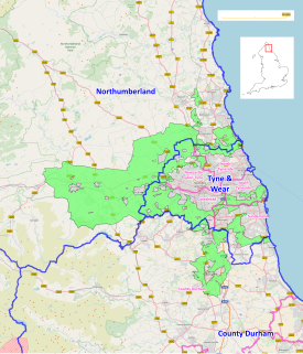
Tyne and Wear ( ) is a metropolitan county in the North East region of England around the mouths of the rivers Tyne and Wear. It came into existence in 1974 after the passage of the Local Government Act 1972. It consists of the five metropolitan boroughs of South Tyneside, North Tyneside, City of Newcastle upon Tyne, Gateshead and City of Sunderland. It is bounded on the east by the North Sea, and has borders with Northumberland to the north and County Durham to the south.

South Shields coastal town at the mouth of the River Tyne, England

South Shields is a coastal town in the North East of England at the mouth of the River Tyne, about 3.7 miles (6.0 km) downstream from Newcastle upon Tyne. Historically in County Durham, the town has a population of 75,337, the third largest in Tyneside after Newcastle and Gateshead. It is part of the metropolitan borough of South Tyneside which includes the towns of Jarrow and Hebburn. South Shields is represented in Parliament by Labour MP Emma Lewell-Buck. The demonym of a person from South Shields is either a Geordie or a Sand dancer.

Newbottle, Tyne and Wear village in the United Kingdom

Newbottle is a village in North East England, lying between Durham and Sunderland, one and a half miles north of Houghton-le-Spring. The village occupies an elevated position and is accessed from three sides up a steep bank.

Marsden, Tyne and Wear village in United Kingdom

Marsden is located on the outskirts of the seaside town South Shields, North East England, located on the North Sea coast.

Souter Lighthouse lighthouse

Souter Lighthouse is a lighthouse located in the village of Marsden in South Shields, Tyne & Wear, England. Souter was the first lighthouse in the world to be actually designed and built specifically to use alternating electric current, the most advanced lighthouse technology of its day.

Jarrow (UK Parliament constituency) Parliamentary constituency in the United Kingdom

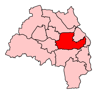
Jarrow is a constituency ESE of and adjoining Newcastle upon Tyne. The constituency has been represented in the House of Commons by Stephen Hepburn of the Labour Party since 1997.

The Boldons village in the United Kingdom

The Boldons are a group of three small villages in the north east of England - East Boldon, West Boldon and Boldon Colliery - north of Sunderland, east of Newcastle and south of South Shields and Jarrow. They have a population of 13,271.

Cleadon village in United Kingdom

Cleadon is a suburban village in South Tyneside, North East England in the county of Tyne and Wear, and the historic County Durham. In 2001 the population of Cleadon was 4,795, increasing for the South Tyneside ward of Cleadon and Boldon at the 2011 Census to 8,457. Nearby villages or population centres include East Boldon, Whitburn, and Jarrow. The village is around 5 miles from the city of Sunderland and 10 miles from the city of Newcastle.

South Shields railway station former railway station in South Shields

South Shields railway station was the main railway station for South Shields, in Tyne and Wear, North-East England. The station was located on Mile End Road in the town centre. The station was opened by the NER in 1879 as the terminus of their newly extended Newcastle and South Shields Railway branch from Pelaw via Hebburn and had two platforms and an ornate overall roof.

The first settlers of the South Shields area were the Brigantes, although there is no evidence they built a settlement at South Shields. The Romans built a fort there to help supply Hadrian's Wall. Many ruins still exist today. The fort was abandoned as the empire declined.

Transport in Tyne and Wear

Tyne and Wear is the metropolitan area which includes all of Newcastle, and the city of Sunderland. However, Tyne and Wear is not an urban area as there are large green spaces between Newcastle and Sunderland. There is currently a large transportation system in Tyne and Wear, which includes a metro system, an exstensive bus network and an international airport. Nexus are the passenger transport executive responsible for transport in Tyne and Wear with its headquarters in Newcastle, the primary transport hub of North East England.

Tees–Wear derby

The Tees–Wear derby is a football local derby contested between Middlesbrough F.C. and Sunderland A.F.C. who are separated by 2 rivers and 30 miles, in the North East of England. Historically this game would be considered the main regional rivalry for Middlesbrough, however it is viewed very much as secondary by those on Wearside, whose main derby match is the Tyne-Wear derby against Newcastle United. Broadly, Sunderland fans based in the City of Sunderland and further north towards Tyneside focus most of their attention on Newcastle. Middlesbrough are an afterthought in these areas primarily due to the increased distance from Teesside, and the lack of regular interaction with Teessiders. The rivalry of the Tees-Wear derby, however, is much more intense and evenly balanced in southern County Durham, where fans of both clubs live and work close together and interact regularly.

The North East Premier League is the top level of competition for recreational club cricket in the North East of England, serving the counties of Durham, Northumberland and Tyne and Wear. Since 2000 it has been a designated ECB Premier League.

Whitburn Colliery was a coal mine located about three miles south of South Shields, North East England, located on the North Sea coast.

North East Combined Authority

The North East Combined Authority is a combined authority that covers part of the North East region of England. It was established by statutory instrument under the Local Democracy, Economic Development and Construction Act 2009 on 15 April 2014. It is a strategic authority with powers over transport, economic development and regeneration. At its first meeting on 15 April 2014, Simon Henig, Leader of Durham County Council, was elected as its chair. The functions, property, rights and liabilities of the former Tyne and Wear Integrated Transport Authority were inherited by the North East Combined Authority, forming an executive body within the new authority as the Tyne and Wear Passenger Transport Executive.

North East Green Belt

The North East Green Belt, also known as the Tyne & Wear Green Belt, is a non-statutory green belt environmental and planning policy that regulates the rural space in part of the North East region of England. It is centred on the county of Tyne and Wear, with areas of belt extending into Northumberland and County Durham. The belt functions to protect surrounding towns and villages outside the Tyneside/Newcastle-upon-Tyne and Wearside/Sunderland conurbations from further convergence. It is managed by local planning authorities on guidance from central government.

References

  1. Office for National Statistics : Census 2001 : Urban Areas : Table KS01 : Usual Resident Population Archived 8 February 2007 at the Wayback Machine Retrieved 26 August 2009
  2. Whitburn Archived 30 September 2007 at the Wayback Machine
  3. BBC – Wear – Coast – Point 7 – The Carroll connection
  4. British Society for the History of Mathematics
  5. "WHITBURN MILL, CEDAR GROVE (east side), BOLDON, SOUTH TYNESIDE, TYNE AND WEAR". English Heritage. Retrieved 21 May 2009.
  6. 1923 Cup Final programme

Coordinates: 54°57′07″N1°21′58″W / 54.95189°N 1.36606°W / 54.95189; -1.36606