
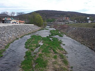
Chillisquaque Creek is a tributary of the West Branch Susquehanna River in Montour County and Northumberland County, in Pennsylvania, in the United States. It is approximately 20.2 miles (32.5 km) long and flows through Derry Township, Washingtonville, and Liberty Township in Montour County and East Chillisquaque Township and West Chillisquaque Township in Northumberland County. The watershed of the creek has an area of 112 square miles (290 km2). Agricultural impacts have caused most of the streams in the watershed of the creek to be impaired. Causes of impairment include sedimentation/siltation and habitat alteration. The average annual discharge of the creek between 1980 and 2014 ranged from 48.2 to 146.0 cubic feet per second. Its watershed mainly consists of rolling agricultural land. The creek's channel flows through rock formations consisting of sandstone and shale. It is a warmwater stream.
Mahoning Creek is a tributary of the Susquehanna River in Columbia County and Montour County, in Pennsylvania, in the United States. It is approximately 10.6 miles (17.1 km) long and flows through Madison Township in Columbia County and West Hemlock Township, Derry Township, Valley Township, Mahoning Township, and Danville in Montour County. The watershed of the creek has an area of 39.6 square miles (103 km2). Its tributaries include Kase Run, Mauses Creek, and Sechler Run. Mahoning Creek is designated as a Trout-Stocking Fishery and a Migratory Fishery for part of its length and as a Warmwater Fishery and a Migratory Fishery for the remainder.

Mud Creek is a tributary of Chillisquaque Creek in Columbia County and Montour County in Pennsylvania, in the United States. It is approximately 8.3 miles (13.4 km) long and flows through Madison Township, Columbia County and Derry Township, Montour County. The main tributaries of the creek are unnamed tributaries. The creek's watershed has an area of 17.70 square miles and is in West Hemlock Township, Montour County as well as the two townships it flows through. The watershed is mostly agricultural and forested and the main developed areas are Washingtonville and Jerseytown.
Middle Branch Chillisquaque Creek is a tributary of Chillisquaque Creek in Columbia County and Montour County, in Pennsylvania, in the United States. It is approximately 5.2 miles (8.4 km) long and flows through Madison Township in Columbia County and Anthony and Derry Townships in Montour County. The creek's watershed has an area of 9.64 square miles (25.0 km2). There are 14.35 miles (23.09 km) of streams in the watershed. Lake Chillisquaque is also in the creek. There are 122 features classified as "disturbances" on Middle Branch Chillisquaque Creek. Two bridges more than 20 feet (6.1 m) long cross the creek.

West Hemlock Creek is a tributary of Hemlock Creek in Montour County and Columbia County, in Pennsylvania, in the United States. It is approximately 3.7 miles (6.0 km) long and flows through West Hemlock Township, Montour County and Hemlock Township, Columbia County. The creek has at least one unnamed tributary. West Hemlock Creek and its unnamed tributary are considered by the Pennsylvania Department of Environmental Protection to be impaired. The watershed of the creek has an area of 2.80 square miles (7.3 km2). The creek is designated as a coldwater fishery. Rock formations in the watershed include the Catskill Formation and the Trimemrs Rock Formation.

Beaver Run is a tributary of Chillisquaque Creek in Montour County and Northumberland County, in Pennsylvania, in the United States. It is approximately 6.2 miles (10.0 km) long and flows through Liberty Township in Montour County and East Chillisquaque Township in Northumberland County. The watershed of the stream has an area of 12.0 square miles (31 km2). Reaches of the stream are designated as impaired due to siltation caused by agriculture. Numerous bridges have been constructed across it and it lacks a riparian buffer in some reaches.
McKee Run is a tributary of County Line Branch in Montour County, Pennsylvania, in the United States. It is approximately 4.1 miles (6.6 km) long and flows through Anthony Township. The watershed of the stream has an area of 2.68 square miles (6.9 km2). The stream is designated as impaired by siltation and removal of vegetation due to agriculture. Land uses in the watershed include forested land, croplands, and pastures. A number of bridges cross the stream.

Fitch Creek is a tributary of the Susquehanna River in Wyoming County, Pennsylvania, in the United States. It is approximately 2.0 miles (3.2 km) long and flows through Falls Township. The watershed of the creek has an area of 2.52 square miles (6.5 km2). The creek is not designated as an impaired waterbody. Its drainage basin is designated as a Coldwater Fishery and a Migratory Fishery.

Kern Glen Creek is a tributary of Billings Mill Brook in Wyoming County, Pennsylvania, in the United States. It is approximately 3.1 miles (5.0 km) long and flows through Lemon Township and Tunkhannock Township. The watershed of the creek has an area of 2.71 square miles (7.0 km2). The creek is not designated as an impaired waterbody. The surficial geology in its vicinity mostly consists of Wisconsinan Till.

Monroe Creek is a tributary of Tunkhannock Creek in Susquehanna County and Wyoming County, in Pennsylvania, in the United States. It is approximately 6.1 miles (9.8 km) long and flows through Springville Township in Susquehanna County and Nicholson Township in Wyoming County. The watershed of the creek has an area of 6.64 square miles (17.2 km2). The creek is not designated as an impaired waterbody. The surficial geology in its vicinity consists mostly of alluvium, Wisconsinan Till, and other things. Its watershed is designated as a Coldwater Fishery and a Migratory Fishery.

Glade Run is a tributary of the West Branch Susquehanna River in Northumberland County and Lycoming County, in Pennsylvania, in the United States. It is approximately 6.5 miles (10.5 km) long and flows through Lewis Township in Northumberland County and Muncy Creek Township and Muncy in Lycoming County. The watershed of the stream has an area of 7.63 square miles (19.8 km2). The stream is not designated as an impaired waterbody. An Indian path known as the Wyoming Path was historically in the stream's vicinity. More recently, a number of bridges have been constructed over Glade Run. The stream's watershed is designated as a Warmwater Fishery and a Migratory Fishery.
Silver Creek is a tributary of the Susquehanna River in Snyder County, Pennsylvania, in the United States. It is approximately 6.1 miles (9.8 km) long and flows through Washington Township and Union Township. The watershed of the creek has an area of 5.92 square miles (15.3 km2). The creek has no named tributaries, but it does have several unnamed tributaries. Many of these, as well as Silver Creek itself, are impaired by sedimentation/siltation due to grazing-related agriculture. The watershed is partly or fully in the Ridge and Valley physiographic province.
Chapman Creek is a tributary of the Susquehanna River in Snyder County, Pennsylvania, in the United States. It is approximately 4.2 miles (6.8 km) long and flows through Union Township and Chapman Township. The watershed of the creek has an area of 2.81 square miles (7.3 km2). The creek has no named tributaries and is not designated as an impaired waterbody. Its drainage basin is designated as a Warmwater Fishery and a Migratory Fishery.
Dalmatia Creek is a tributary of the Susquehanna River in Northumberland County, Pennsylvania, in the United States. It is approximately 2.8 miles (4.5 km) long and flows through Lower Mahanoy Township. The watershed of the creek has an area of 2.80 square miles (7.3 km2). The creek has no named tributaries, but several unnamed ones. Both it and its tributaries are designated as impaired waterbodies due to sedimentation/siltation from crop-related agriculture and vegetation removal. Streambank erosion also occurs in the watershed. The creek is in the Ridge and Valley physiographic province.
Hoffer Creek is a tributary of the Susquehanna River in Snyder County, Pennsylvania, in the United States. It is approximately 3.1 miles (5.0 km) long and flows through Chapman Township. The watershed of the creek has an area of 2.34 square miles (6.1 km2). At least part of the creek is designated as an impaired waterbody due to sedimentation/siltation from grazing-related agriculture. The creek is in the ridge and valley physiographic province, and the geology consists mostly of intermedded sedimentary rock and sandstone.
Deep Creek is a tributary of Mahantango Creek in Dauphin County, Pennsylvania, in the United States. It is approximately 5.9 miles (9.5 km) long and flows through Lykens Township and Pillow. The watershed of the creek has an area of 10.6 square miles (27 km2). It is not designated as an impaired waterbody, but is nevertheless observed to have high nitrate concentrations. Major land uses in the creek's watershed include agricultural land and forested land. The creek's watershed is classified as a Warmwater Fishery.
Snow Creek is a tributary of Mahantango Creek in Northumberland County, Pennsylvania, in the United States. It is approximately 3.8 miles (6.1 km) long and flows through Upper Mahanoy Township and Jordan Township. The watershed of the creek has an area of 4.72 square miles (12.2 km2). The creek has no named tributaries and is not designated as an impaired waterbody in any stream segment.
Tower Branch is a tributary of Tunkhannock Creek in Susquehanna County, Pennsylvania, in the United States. It is approximately 4.8 miles (7.7 km) long and flows through Harford Township and Lenox Township. The watershed of the stream has an area of 3.69 square miles (9.6 km2). The stream is not designated as an impaired waterbody and has no named tributaries. The surficial geology in its vicinity consists mainly of Wisconsinan Till, alluvium, with some lakes, wetlands, bedrock, and alluvial fan. The stream's drainage basin is classified as a Coldwater Fishery and a Migratory Fishery.
Dundaff Creek is a tributary of East Branch Tunkhannock Creek in Susquehanna County and Lackawanna County, in Pennsylvania, in the United States. It is approximately 6.7 miles (10.8 km) long and flows through Clifford Township in Susquehanna County and Greenfield Township in Lackawanna County. The watershed of the creek has an area of 10.3 square miles (27 km2). The creek has no named tributaries and is not designated as an impaired waterbody.


