
LaSalle Parish is a parish located in the U.S. state of Louisiana. As of the 2010 census, the population was 14,890. The parish seat is Jena. The parish was created in 1910 from the western section of Catahoula Parish and named for René-Robert Cavelier, Sieur de La Salle.

Grant Parish is a parish located in the North Central portion of the U.S. state of Louisiana. As of the 2010 census, the population was 22,309. The parish seat is Colfax. The parish was founded in 1869.

East Baton Rouge Parish is the most populous parish in the U.S. state of Louisiana. As of the 2010 census, the population was 440,171. The parish seat is Baton Rouge, Louisiana's state capital.

Jena is a town in, and the parish seat of, La Salle Parish, Louisiana, United States. The population was 3,398 at the 2010 census.
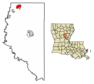
Olla is a town in northwest La Salle Parish, Louisiana, United States, located in the heart of the Louisiana Central Hill Country.
Whitehall is a street in central London.
Whitehall, Louisiana may refer to:
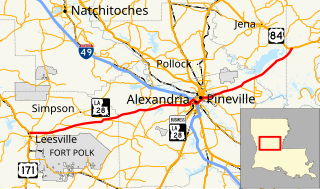
Louisiana Highway 28 (LA 28) is a state highway located in central Louisiana. It runs 86.97 miles (139.96 km) in an east–west direction from the junction of U.S. Highway 171 (US 171) and LA 8 in Leesville to US 84 west of Jonesville.

Louisiana Highway 29 (LA 29) is a state highway located in southern Louisiana. It runs 54.09 miles (87.05 km) in a north–south direction from LA 13 north of Eunice to LA 114 west of Moreauville.
Maurepas is an unincorporated community in the south/southwestern area of Livingston Parish, Louisiana, United States. Louisiana Highway 22 passes through the community and Whitehall lies two miles to the east. Lake Maurepas is six miles to the east and the Amite River lies approximately one half mile to the north.
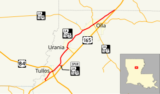
Louisiana Highway 125 (LA 125) is a state highway located in LaSalle Parish, Louisiana. It runs 12.51 miles (20.13 km) in a southwest to northeast direction from U.S. Highway 165 (US 165) in Tullos to a second junction with US 165 northeast of Olla.

This is a list of the National Register of Historic Places listings in La Salle Parish, Louisiana.

Creston is an unincorporated community in Natchitoches Parish, Louisiana, United States. Creston is not included in the 2010 United States Census. The community is part of the Natchitoches Micropolitan Statistical Area.

Standard is an unincorporated community in LaSalle Parish, Louisiana, United States.
Rhinehart is an unincorporated community in La Salle and Catahoula parishes, Louisiana, United States. The community is located on Louisiana Highway 8, 8.1 miles (13.0 km) east-southeast of Jena. Rhinehart has a post office with ZIP code 71363.
Whitehall is an unincorporated community located in Livingston Parish, Louisiana, United States. The community is on Louisiana Highway 22 and Maurepas lies approximately two miles to the northeast. The Amite River flows past the northwest side of the community.

Bayou Barbary is an unincorporated community in Livingston Parish, Louisiana, United States. The community is located on Louisiana Highway 444 5 mi (8.0 km) west of Killian, 3.5 mi (5.6 km) east of Verdun and 1 mi (1.6 km) north of the Amite River.


