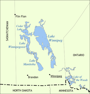
Lake Winnipeg is a very large, relatively shallow 24,514-square-kilometre (9,465 sq mi) lake in North America, in the province of Manitoba, Canada. Its southern end is about 55 kilometres (34 mi) north of the city of Winnipeg. Lake Winnipeg is Canada's sixth-largest freshwater lake and the third-largest freshwater lake contained entirely within Canada, but it is relatively shallow excluding a narrow 36 m (118 ft) deep channel between the northern and southern basins. It is the eleventh-largest freshwater lake on Earth. The lake's east side has pristine boreal forests and rivers that were in 2018 inscribed as Pimachiowin Aki, a UNESCO World Heritage Site. The lake is 416 km (258 mi) from north to south, with remote sandy beaches, large limestone cliffs, and many bat caves in some areas. Manitoba Hydro uses the lake as one of the largest reservoirs in the world. There are many islands, most of them undeveloped.

Lake of the Woods is a lake occupying parts of the Canadian provinces Ontario and Manitoba along with the U.S. state of Minnesota. Lake of the Woods is over 70 miles (110 km) long and wide, containing more than 14,552 islands and 65,000 miles (105,000 km) of shoreline. It is fed by the Rainy River, Shoal Lake, Kakagi Lake and other smaller rivers. The lake drains into the Winnipeg River and then into Lake Winnipeg. Ultimately, its outflow goes north through the Nelson River to Hudson Bay.

Canada has a large domestic and foreign tourism industry. The second largest country in the world, Canada's incredible geographical variety is a significant tourist attractor. Much of the country's tourism is centred in the following regions: Toronto, Montreal, Quebec City, Vancouver/Whistler, Niagara Falls, Vancouver Island, Canadian Rockies, British Columbia's Okanagan Valley, Churchill, Manitoba and the national capital region Ottawa. The large cities are known for their culture, diversity, as well as the many national parks and historic sites.
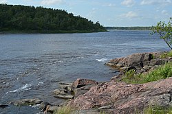
The Winnipeg River is a Canadian river that flows roughly northwest from Lake of the Woods in the province of Ontario to Lake Winnipeg in Manitoba. This river is 235 kilometres (146 mi) long from the Norman Dam in Kenora to its mouth at Lake Winnipeg. Its watershed is 106,500 square kilometres (41,100 sq mi) in area, mainly in Canada. About 29,000 square kilometres (11,000 sq mi) of the watershed is in northern Minnesota, United States.

Petroforms, also known as boulder outlines or boulder mosaics, are human-made shapes and patterns made by lining up large rocks on the open ground, often on quite level areas. Petroforms in North America were originally made by various Native American and First Nation tribes, who used various terms to describe them. Petroforms can also include a rock cairn or inukshuk, an upright monolith slab, a medicine wheel, a fire pit, a desert kite, sculpted boulders, or simply rocks lined up or stacked for various reasons. Old World petroforms include the Carnac stones and many other megalithic monuments.

West Hawk Lake is a impact crater lake on the Whiteshell River located in the Whiteshell Provincial Park in southeastern Manitoba, Canada. The circular shape of the main body of the lake is due to the submerged West Hawk crater, caused by a meteor impact into an ancient rock bed composed of mostly granite. At 115 metres (377 ft), it is the deepest lake in Manitoba.
Pinawa is a local government district and small community of 1,331 residents located in southeastern Manitoba, Canada. It is 110 kilometres north-east of Winnipeg. The town is situated on the Canadian Shield within the western boundary of Whiteshell Provincial Park, which lies near the Manitoba-Ontario provincial boundary. Administratively, the town includes the surrounding area, and is officially the Local Government District of Pinawa. Except for a small eastern border with the unorganized area of the Eastman Region, it is surrounded by the Rural Municipalities of Lac du Bonnet to the north and Whitemouth to the south, but is independent of either one. The community lies on the north bank of the Winnipeg River in the southeastern part of the Local Government District.

Eastern Manitoba, or the Eastman Region, is an informal geographic region of the Canadian province of Manitoba. It is bounded on the north by the Winnipeg River and Lake Winnipeg, on the east by the Manitoba-Ontario border, on the south by the Canada–US border, and on the west by the Red River.
Beausejour is a town in the Canadian province of Manitoba. It is 46 kilometres northeast of Winnipeg, just west of the Canadian Shield and Whiteshell Provincial Park. The French name Beauséjour [beau + séjour] means "beautiful stay". The town is surrounded by the Rural Municipality of Brokenhead. Originally known as Stony Prairie, Beausejour was named in 1877 by Mrs H.W.D. Armstrong, wife of a government railway surveyor, when a telegraph office was installed there to serve settlers along the nearby Brokenhead River.

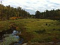
Whiteshell Provincial Park is a 2,721 km2 park centrally located in Canada in the province of Manitoba. It is found in the southeast region of the province along the Manitoba-Ontario boundary, approximately 130 km east of the city of Winnipeg. The park is located in the Canadian Shield region and has many rivers, remote lakes, boreal forest and bare granite ridges. It has rare archeological sites of petroforms on flat granite ridges. The park is used year-round for nature-oriented recreation activities.

The deepwater sculpin is a freshwater sculpin that inhabits the bottoms of cold, deep freshwater lakes of northern North America. Its distribution ranges from the Great Bear Lake of Canada to the Great Lakes. It is a designated at-risk fish species in Canada, protected as a species of Special Concern under Canada's Species at Risk Act.
Atikaki Provincial Park is a wilderness park in Manitoba, Canada located east of Lake Winnipeg along the Ontario boundary in the Canadian Shield. The area of Atikaki Provincial Park is 3,981 km2. Atikaki Provincial Park is north of Nopiming Provincial Park and borders the Woodland Caribou Provincial Park in Ontario.

The history of Manitoba covers the period from the arrival of Paleo-Indians thousands of years ago to the present day. When European fur traders first travelled to the area present-day Manitoba, they developed trade networks with several First Nations. European fur traders in the area during the late-17th century, with the French under Pierre Gaultier de Varennes, sieur de La Vérendrye set up several trading post forts. In 1670, Britain declared sovereignty over the watershed of Hudson's Bay, known as Rupert's Land; with the Hudson's Bay Company granted a commercial monopoly over the territory.
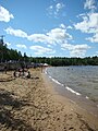
Falcon Lake is an unincorporated urban centre at the western end of Falcon Lake situated in the southeasternmost section of the Whiteshell Provincial Park in the Canadian province of Manitoba. It is the major entry point to the Whiteshell from the Trans-Canada Highway. Three provincially operated campgrounds, Falcon Creek, Falcon Beach and Falcon Lakeshore, picnic areas, a swimming beach and adjacent public boat launch, several cottage lot divisions and numerous tourist services make the community a favored entrance point to the provincial park. In 2003, 40% of park visitors entered the park at the Falcon Lake checkpoint.
Caddy Lake is a lake on the Whiteshell River in south-eastern Manitoba, Canada near the Manitoba–Ontario border. McGillivray Creek drains into the lake on its west side.It is within Whiteshell Provincial Park near West Hawk Lake. The lake has a surface area of about 300 hectares and a maximum depth of 5.7 metres (19 ft).

The Midwestern Canadian Shield forests ecoregion, in the Taiga and Boreal forests Biome, are of northern Canada.

The Western Great Lakes forests is a terrestrial ecoregion as defined by the World Wildlife Fund. It is within the temperate broadleaf and mixed forests biome of North America. It is found in northern areas of the United States' states of Michigan, Wisconsin and Minnesota, and in southern areas of the Canadian province of Manitoba and northwestern areas of the province of Ontario.
Provincial Road 307 is a provincial road in the eastern part of the Canadian province of Manitoba. It is part of the La Vérendrye Trail in eastern Manitoba and lies mostly within Whiteshell Provincial Park.
The La Vérendrye Trail is a series of highways in the Canadian province of Manitoba commemorating the oldest waterway fur-trading route in the province. It is named after Pierre Gaultier de Varennes, sieur de La Vérendrye, an explorer and fur-trader who is often credited as being the first European to visit what is now southern Manitoba.